List of districts of Tripura
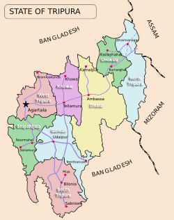
The Indian state of Tripura borders with Bangladesh and the Indian states of Assam & Mizoram. The third smallest state in India[1] and also a princely state till 1949, It covers an area of 10,491 km2 (4,051 sq mi).The area of modern Tripura was ruled for several centuries by the Tripuri dynasty. It was a princely state during British rule, and joined the newly independent India.Ethnic strife between the indigenous people and Bengali population led to tension and scattered violence since its integration into the country, but the establishment of an autonomous tribal administrative agency and other strategies have led to peace. Tripura was divided into 4 districts but with effect from 21 January 2012 four more new districts was divided making a total of 8 districts in the state.[2]
History
Dating back to the time of Mahabharatha, the very helm of the Kingdom of Tripura encompassed the greater part of Eastern Bengal stretching from the Bay of Bengal in the South to the Brahmaputra in the North and west and Burma, now Myanmar in the East. The earliest trace of the history of Tripura can be found in the Ashokan pillar inscriptions.[3] The 17th Century is a major watershed in the history of Tripura when the administration of the region passed on the hands of the Mughals with some powers left with the Manikyas. In the Colonial era, the Britishers extended their control over Tripura granting some limited independence to the Manikya kings. The region was under the rule of the Twipra Kingdom for centuries, although when this dates from is not documented. The Rajmala, a chronicle of Tripuri kings which was first written in the 15th century,[4] provides a list of 179 kings, from antiquity up to Krishna Kishore Manikya (1830–1850),[5]:3[6][7] but the reliability of the Rajmala has been doubted.[8] The Royal history of Tripura ended when the princely state acceded to the Indian Union on October 15, 1949. After death of the last king Maharaja Bir Bikram Kishore Manikya on May 17, 1947, a Regency Council was formed headed by Maharani Kanchan Prabha Devi, for aid of the minor Prince, Kirit Bikram Kishore Manikya Bahadur. The regent signed the merger agreement with the Government of India. After merger Tripura became a Part ‘C’ State. On reorganization of the states, effected in November, 1956, Tripura became a Union Territory with an Advisory Committee to aid and advise the Chief Commissioner. Thereafter in place of the Advisory Committee, a Territorial Council was formed through the adult franchise on 15 August 1957. On July 1, 1963, the Tripura Territorial Council was dissolved and the Legislative Assembly with the existing members of the Territorial Council was formed. On January 21, 1972 Tripura became full-fledged State by the Act of Parliament called the North Eastern Areas (Reorganization) Act, 1971.[9]
Former administrative structure
| Code | District | Headquarters | Population (2011)[10] | Area (km²) | Density (/km²)[10] | Official website |
| DH | Dhalai | Ambassa | 377,988 | 2,523 | 157 | http://dhalai.gov.in/ |
| NT | North Tripura | Kailasahar | 693,281 | 2,821 | 341 | http://northtripura.nic.in/ |
| ST | South Tripura | Udaipur | 875,144 | 2,152 | 286 | http://southtripura.nic.in/ |
| WT | West Tripura | Agartala | 1,724,619 | 2,997 | 576 | http://westtripura.nic.in/ |
New list of Districts after the reorganization
For administrative purposes, the state has been divided into 8 districts, 23 subdivisions and 58 development blocks - with effect from 21 January 2012, after a Government of Tripura Decision, out of which the newly created districts are 4, subdivisions 6, development blocks 5. The four new Districts are Khowai Unakoti, Sipahijala and Gomati; the six new sub-divisions are Jirania, Mohanpur, Kumarghat, Panisagar, Jampuijala and Karbook; the five new development blocks are Yuvarajnagar, Durga Chawmuhani, Jolaibari, Silachari and Lefunga.
The information here are latest updated as of 25.05.2015[11]
| District | Headquarters | District Magistrat | Police Super | Subdivisions | Development Blocks | Municipals | Population [tentative, as per Census 2011(P), as released by the Govt of Tripura] | Area (in km2) |
|---|---|---|---|---|---|---|---|---|
| Dhalai | Ambassa | Dr. Sandeep R. Rathod, IAS | Lal Minga Darlong | 1. Kamalpur 2. Ambassa 3. Longtarai Valley 4. Gandachera | 1. a) Salema 1. b) Durga Chawmuhani 2. a) Ambassa 3. a) Manu 3. b) Chawmanu 4. a) Dumburnagar 4. b) Raishyabari | 1. a) Kamalpur Nagar Panchayet 2. a) Ambassa Municipal Council | 377,988 | NA |
| Sipahijala | Bishramganj | Sri. Pradeep Kr. Chakravarty, IAS | Smiti Ranjan Das | 1. Bishalgarh 2. Jampuijala 3. Sonamura | 1. a) Bishalgarh 2. a) Jampuijala 3. a) Melaghar 3. b) Kathalia 3. c) Boxanagar | 1. a) Bishalgarh Municipal Council 3. a) Sonamura Nagar Panchayet 3. b) Melaghar Municipal Council | 484,233 | NA |
| Khowai | Khowai | Ngurchawikunga Darlong, IAS | Pradip Paul | 1. Khowai 2. Teliamura | 1. a) Khowai 1. b) Tulashikhar 1. c) Padmabil 2. a) Teliamura 2. b) Kalyanpur 2. c) Mungiakami | 1. a) Khowai Municipal Council 2. a) Teliamura Municipal Council | 327,391 | NA |
| Gomati | Udaipur | Smt. Sonal Goel, IAS | Thirughana Sambardhan S | 1. Udaipur 2. Amarpur 3. Karbook | 1. a) Matabari 1. b) Kakraban 1. c) Killa 2. a) Amarpur 2. b) Ompi 3. a) Karbook 3. b) Silachari | 1. a) Udaipur Municipal Council 2. a) Amarpur Nagar Panchayet | 436,868 | NA |
| Unakoti | Kailashahar | Sri Mrinal Kanti Nath, I.A.S. | Princi Rani | 1. Kumarghat 2. Kailashahar | 1. a) Kumarghat 1. b) Pecharthal 2. a) Gournagar | 1. a) Kumarghat Municipal Council 2. a) Kailashahar Municipal Council | 277,335 | NA |
| North Tripura | Dharmanagar | Santirai Riyan | Bijoy Kumar Nag | 1. Dharmanagar 2. Kanchanpur 3. Panisagar | 1. a) Kadamtala 1. b) Yuvarajnagar 2. a) Dasda 2. b) Jampuihill 2. c) Laljuri 3. a) Panisagar 3. b) Damchara | 1. a) Dharmanagar Municipal Council | 415,946 | NA |
| South Tripura | Belonia | Dr. Debasish Basu, I.A.S. | Sankar Debnath | 1. Santirbazar 2. Belonia 3. Sabroom | 1. a) Bakafa 1. b) Jolaibari 2. a) Hrishyamukh 2. b) Rajnagar 2. c) Bharat Chandra Nagar 3. a) Satchand 3. b) Rupaichari 3. c) Poangbari | 1. a) Santirbazar Municipal Council 2. a) Belonia Municipal Council 3. a) Sabroom Nagar Panchayet | 433,737 | NA |
| West Tripura | Agartala | Dr. Milind Ramteke, IAS | R G K Rao | 1. Sadar 2. Mohanpur 3. Jirania | 1. a) Dukli 2. a) Mohanpur 2. b) Hezamara 2. c) Lefunga 3. a) Jirania 3. b) Mandai | 1. a) Agartala Municipal Corporation 3. a) Ranirbazar Municipal Council | 917,534 | NA |
Demographics
The following is a list of the basic demographic data for the districts of Tripura based on the size of the district's area, arranged in descending order[12][12] (The data input here is taken from 2011 Census, however the new four districts were formed in 2012 so information on those are of 2012)
| District | Area in km2. | Population | Growth Rate | Sex Ratio | Literacy | Density/KM |
|---|---|---|---|---|---|---|
| Dhalai | 2400 | 3,77,988 | 12.57 | 945 | 86.82 | 157 |
| South Tripura | 1534.2 | 4,33,737 | 14.15 | 956 | 85.09 | 283 |
| Gomati | 1522.8 | 4,36,868 | 14.15 | 959 | 86.19 | 287 |
| North Tripura | 1444.5 | 4,15,946 | 17.44 | 968 | 88.77 | 288 |
| Sipahijala | 1044.78 | 4,84,233 | 14.15 | 952 | 84.14 | 463 |
| Khowai | 1005.67 | 3,27,391 | 14.15 | 961 | 88.37 | 326 |
| West Tripura | 942.55 | 9,17,534 | 12.57 | 972 | 91.69 | 973 |
| Unakoti | 591.93 | 2,77,335 | 10.85 | 966 | 87.58 | 469 |
References
- ↑ Tripura the 3rd smallest state in India
- ↑ new districts of tipura
- ↑ ashok pillar mahabharata
- ↑ "Hill Tippera – history" (GIF). The Imperial Gazetteer of India. 13: 118. 1909. Retrieved 27 October 2011.
- ↑ Bera, Gautam Kumar (2010). The land of fourteen gods: ethno-cultural profile of Tripura. Mittal Publications. ISBN 978-81-8324-333-9.
- ↑ Sen, Kali Prasanna, ed. (2003). Sri rajmala volume – IV (in Bengali). Tribal Research Institute, Government of Tripura. Retrieved 10 May 2013.
- ↑ Bhattacharyya, Apurba Chandra (1930). Progressive Tripura. Inter-India Publications. p. 179. OCLC 16845189.
- ↑ Sircar, D.C. (1979). Some epigraphical records of the mediaeval period from eastern India. Abhinav Publications. p. 89. ISBN 978-81-7017-096-9.
- ↑ end of king era of tripura
- 1 2 "Distribution of Population, Decadal growth rate, Sex ratio and Population density for State and District" (XLS). The Registrar General & Census Commissioner, India, New Delhi-110011. 2010–2011. Retrieved 2011-09-18.
- ↑ http://www.thehindu.com/news/national/other-states/agartala-turns-into-a-municipal-corporation-tomorrow/article5597581.ece
- 1 2 http://www.census2011.co.in/census/state/districtlist/tripura.html
Newly added four district and 6 sub division. DHARMANAGAR is one of four newly added district http://ibnlive.in.com/generalnewsfeed/news/four-new-districts-six-subdivisions-for-tripura/876579.html
External links
| Wikimedia Commons has media related to Districts of Tripura. |
| States | ||
|---|---|---|
| Union Territories | ||
| Related topics | ||