List of districts of Manipur
Map of districts of Manipur
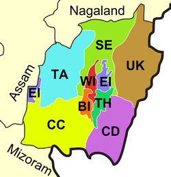
Manipur, a state of India, has nine administrative districts.
Administration
A district of an Indian state is an administrative geographical unit, headed by a district magistrate or a deputy commissioner, an officer belonging to the Indian Administrative Service. The district magistrate or the deputy commissioner is assisted by a number of officials belonging to different wings of the administrative services of the state.
A superintendent of Police, an officer belonging to Indian Police Service is entrusted with the responsibility of maintaining law and order and related issues.
Districts
The nine districts of Manipur state are:
| Code | District | Headquarters | Population (2011)[1] | Area (km²) | Density (/km²) | Official website |
| BI | Bishnupur | Bishnupur | 240,363 | 496 | 415 | http://bishnupur.nic.in/ |
| CC | Churachandpur | Churachandpur | 271.274 | 4,574 | 50 | http://churachandpur.nic.in/ |
| CD | Chandel | Chandel | 144,028 | 3,317 | 37 | http://chandel.nic.in/ |
| EI | Imphal East | Porompat | 452,661 | 710 | 555 | http://imphaleast.nic.in/ |
| SE | Senapati | Senapati | 354,772 | 3,269 | 116 | http://Senapati.nic.in/ |
| TA | Tamenglong | Tamenglong | 140,143 | 4,391 | 25 | http://tamenglong.nic.in/ |
| TH | Thoubal | Thoubal | 420,517 | 514 | 713 | http://thoubal.nic.in/ |
| UK | Ukhrul | Ukhrul | 183,115 | 4,547 | 31 | http://ukhrul.nic.in/ |
| WI | Imphal West | Lamphelpat | 514,683 | 519 | 847 | http://imphalwest.nic.in/ |
References
- ↑ "Ranking of Districts by Population Size, 2001 and 2011" (XLS). The Registrar General & Census Commissioner, India, New Delhi-110011. 2010–2011. Retrieved 2011-09-18.
| States | ||
|---|---|---|
| Union Territories | ||
| Related topics | ||
This article is issued from Wikipedia - version of the 8/15/2015. The text is available under the Creative Commons Attribution/Share Alike but additional terms may apply for the media files.