List of crossings of the South Saskatchewan River
This is a list of crossings of the South Saskatchewan River in the Canadian provinces of Saskatchewan and Alberta, from the river's confluence with the North Saskatchewan River at Saskatchewan River Forks, upstream to its origin at the confluence of the Bow and Oldman Rivers.
- This transport-related list is incomplete; you can help by expanding it.
Saskatchewan
Alberta
| Crossing | Carries | Location | Notes | Coordinates |
|---|---|---|---|---|
| Highway bridge | Highway 41 | south of Empress | 50°43′52″N 110°04′08″W / 50.731°N 110.069°W | |
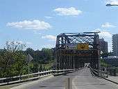
| Maple Avenue Bridge[15] | Altawana Drive NE to Maple Avenue | Medicine Hat | 50°02′42″N 110°40′26″W / 50.045°N 110.674°W | |
| Railway bridge[16] | Canadian Pacific Railway | 50°02′38″N 110°40′34″W / 50.044°N 110.676°W | ||
| Finlay Bridge[17] | 2nd Avenue NE to 6th Avenue SE | 50°02′35″N 110°40′44″W / 50.043°N 110.679°W | ||
| Highway bridge[18] | Highway 1 | twin spans | 50°02′38″N 110°43′08″W / 50.044°N 110.719°W | |
| Highway bridge | Highway 879 | northwest of Bow Island | 49°54′18″N 111°28′37″W / 49.905°N 111.477°W |
Pipeline bridge
The pipeline suspension bridge was erected in 1957 19 kilometres (12 mi) west of Burstall across the South Saskatchewan River.[19][20]
Proposed crossings
South Circle Drive Bridge is a bridge proposed to open 2012 completing Circle Drive around Saskatoon.[21][22] The city of Medicine Hat hosted a public meeting proposing a Sanitary Sewer and Water Pipeline which is intended to cross the South Saskatchewan River.[23]

References
- 1 2 3 4 5 6 7 Province of Saskatchewan, Ferry Information - Highways and Infrastructure -, retrieved 2008-12-24
- ↑ Prince Albert Tourism, Prince Albert (PDF), retrieved 2008-12-24
- ↑ Government of Saskatchewan, Saskatchewan Road and Railway Bridges to 1950, retrieved 2008-12-24
- ↑ Government of Saskatchewan (September 5, 2001), NEW LOCATION FOR ST. LOUIS BRIDGE -, retrieved 2008-12-24
- ↑ METISNET: A HANDBOOK OF METIS FACTS, FANCIES & FIGURES SECTION G ..., retrieved 2008-12-24
- ↑ Gregg, Peter; Historic Trails Canoe Club; Ministry of Tourism, Sports and Recreation. (1989), Canoe Trip, retrieved 2008-12-24
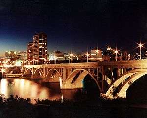
- 1 2 3 City of Saskatoon (2006), Saskatoon 100, retrieved 2008-12-24
- 1 2 3 4 5 BRIDGES OF SASKATOON The Wonder City Photo Gallery, retrieved 2008-12-24
- ↑ City of Saskatoon, Circle Drive South Project, retrieved 2011-07-16
- ↑ Town of Outlook, SkyTrail - Canada's Longest Pedestrian Bridge, retrieved 2008-12-24
- ↑ Government of Saskatchewan (October 8, 1998), NEW OUTLOOK BRIDGE OFFICIALLY OPENED
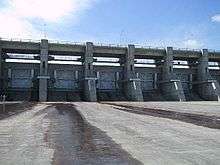
- ↑ Saskatchewan Schools, Discover Lake Diefenbaker - The Gardiner Dam, retrieved 2008-12-24
- ↑ Ferries and Bridges, Saskatchewan Landing, retrieved 2008-12-24
- ↑ WDM Prairie Gamble - Family History Album - Story - Chesterfield ..., retrieved 2008-12-24
- ↑ LANE CLOSURES FOR BRIDGE INSPECTION MAPLE AVE BRIDGE, ALLOWANCE ...
- ↑ Anderton, G.T. (1883), The Glenbow Museum Archives Photographs Search Results First train across South Saskatchewan river, Medicine Hat, Alberta, Image No: NA-2622-10 and Image No: NA-2622-11, archived from the original on April 9, 2014, retrieved 2008-12-24
- ↑ CITY CELEBRATES FINLAY BRIDGE 100 ANNIVERSARY (PDF), retrieved 2008-12-24
- ↑ FoundLocally.com Media Inc (1999–2008), Alberta Trans-Canada Highway Route: Highway #1 between Calgary and Medicine Hat, retrieved 2008-12-24
- ↑ Southwest Regional Economic Development Authority Inc., LOCATION, retrieved 2008-12-24
- ↑ Untitled Document, retrieved 2008-12-24 Image of pipeline bridge
- ↑ Circle Drive South Bridge, retrieved 2008-12-24
- ↑ City of Saskatoon · Departments · Infrastructure Services ... South River Crossing.ppt, retrieved 2008-12-24
- ↑ Medicine Hat, OPEN HOUSE SOUTH SASKATCHEWAN RIVER PIPELINE CROSSING (PDF), retrieved 2008-12-24
This article is issued from Wikipedia - version of the 7/27/2015. The text is available under the Creative Commons Attribution/Share Alike but additional terms may apply for the media files.