Colonial architecture in Jakarta
Colonial buildings and structures in Jakarta include those that were constructed during the Dutch colonial period of Indonesia. The period (and the subsequent style) succeeded the earlier period when Jakarta (known then as Jayakarta/Jacatra), governed by the Sultanate of Banten, were completely eradicated and replaced with a walled city of Batavia.[1] The dominant styles of the colonial period can be divided into three periods: the Dutch Golden Age (17th to late 18th century), the transitional style period (late 18th century – 19th century), and Dutch modernism (20th century). Dutch colonial architecture in Jakarta is apparent in buildings such as houses or villas, churches, civic buildings, and offices, mostly concentrated in the administrative city of Central Jakarta and West Jakarta.
Below is a list of colonial buildings and structures found in Jakarta. The list is sorted alphabetically according to its official (local) name. The list can also be sorted to each category.
Buildings which undertook complete renovation which resulted in different form are listed separately to distinguish the different architectural form.
Some notable Chinese-style buildings and Islamic mosques that were built during these period are included in the list for comparison.
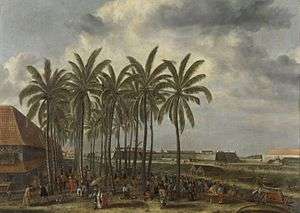
Dutch East India Company period – 17th to late 18th century
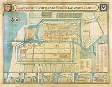
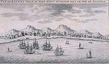
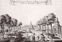
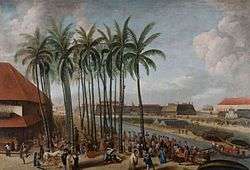
The first type of colonial architecture grew from the early Dutch settlements in the 17th century, when settlements were generally within walled defences to protect them from attack by other European trade rivals and native revolt. Following the siege of Jayakarta (previously known as Sunda Kelapa) and its demolition by the Dutch in 1619, it was decided to build the headquarters of the Dutch East India Company on the site. Simon Stevin was commissioned to design a plan for the future settlement based on his concept of the 'ideal city'. His response was a rectangular, walled town, bisected by the river Ciliwung which was to be channeled into a straight canal (later known as also known as Grote Rivier or Kali Besar or "Big River" in this area). This new city is called Batavia (now Jakarta). In accordance to Stevin's model, the fortress of Batavia was the most prominent building in the city, symbolizing the center of power, while townhall, markets, and other public buildings were distributed. This layout of Jakarta can still be clearly recognized today in Jakarta Old Town through the layout of the streets and canals, although most of the original 17th structures had been destroyed or replaced with newer early 20th-century structures.[2]
The architecture style of this period were the tropical counterparts of 17th-century Dutch architecture. Typical features include the typically Dutch high sash windows with split shutters,[2] gable roofs,[2] and white-coral painted wall (as opposed to exposed brick architecture in the Netherlands). This earlier period of Jakarta had many of the buildings solidly built with relatively enclosed structures, a structure that is not very friendly to tropical climate as compared to the architecture of the next period in Jakarta.[2] Best example of these buildings were located along the Tygersgracht (now Jalan Muka Timur), all had been demolished.[2] Best surviving example is Toko Merah.
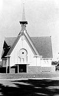
Several Portuguese colonial architecture also exist, usually outside the walled city of Batavia. Tugu Church and Sion Church, with its plain facade and domed windows, are some surviving examples.
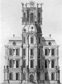
In 1808, Daendels officially moved the city center to south because of the deteriorating condition of the inner town as well as the malaria outbreak. As a result, many buildings and structures from this period were left to deteriorate. Because of financial issues, many buildings were demolished in the 19th century and the debris were used to construct newer structure in the south, such as the Palace of Governor-General Daendels (now the Financial Department of Indonesia) from the debris of Batavia Castle, and Batavia Theater (now Gedung Kesenian Jakarta) from the debris of the Spinhuis.
Later, these empty lots in Jakarta Old Town were filled with newer 20th-century structures. Surviving 17th–18th structures were later converted as Jakarta's cultural heritage, e.g. Toko Merah, Gereja Sion and Jakarta History Museum.
Other dominant architecture style from these period were the Chinese merchant houses, many were built during the 18th century. Many of these structures show eclectic mix of Dutch and Chinese influences.[2]
| Last official name | Former names | Year | Architect | Location | Latest image | Oldest image |
|---|---|---|---|---|---|---|
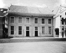
| 18th-century Dutch mansion at Kali Besar Barat | Bank of China, formerly Firma Tels & Co[3] | 18th century | anonymous | 6°08′11″S 106°48′41″E / 6.136367°S 106.811372°E |  |
 |
| Arsip Nasional | Reiner de Klerk house[2] | 1760 | Reiner de Klerk | 6°09′14″S 106°49′01″E / 6.153761°S 106.817036°E |  |
 |
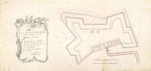
| Baijen’s Country House and the Outer Hospital (demolished, replaced by Citadel Prins Frederik) | Baijen’s Country House and the Buiten-hospital[4] | before 1669, later a hospital, from 1743 until 1820.[4] | anonymous | 6°10′13″S 106°49′51″E / 6.170386°S 106.830742°E | ||
| Bastion Amsterdam (demolished) | Amsterdam | 1632-1635[5] | anonymous | 6°07′46″S 106°48′54″E / 6.129527°S 106.815078°E | — |
 |
| Bastion Buren (demolished) | Buren | before 1650[6] | anonymous | 6°07′41″S 106°48′28″E / 6.128014°S 106.807904°E | — |
|
| Bastion Cuylenburg (demolished, on its site stands Menara Syahbandar) | Cuylenburg, Cullenburch, Culemborg[7] | 1645[3][6][8] | anonymous | 6°07′39″S 106°48′33″E / 6.127527°S 106.809071°E |  | |
| Bastion Diest and gate (demolished) | Diest, Diestpoort | 1632-1635[5] | anonymous | 6°08′12″S 106°48′42″E / 6.136733°S 106.811704°E |  |
 |
| Bastion Enkhuizen (demolished) | Enkhuizen | 1627-1632[5] | anonymous | 6°08′05″S 106°48′59″E / 6.134680°S 106.816474°E |  |
 |
| Bastion Friesland (demolished) | Friesland | 1632-1635[6] | anonymous | 6°07′55″S 106°48′22″E / 6.131831°S 106.806058°E | — |
|
| Bastion Gelderland (demolished) | Gelderland, Punt Gelderland | 1627-1632[5] | anonymous | 6°08′15″S 106°49′00″E / 6.137472°S 106.816785°E | |
 |
| Bastion Grimbergen (demolished) | Grimbergen | 1635-1650[5] | anonymous | — |
||
| Bastion Groningen (demolished) | Groningen | 1632-1635 (replacing the older Buren fortification)[5] | anonymous | 6°07′37″S 106°48′17″E / 6.126864°S 106.804796°E | — |
 |
| Bastion Hollandia (demolished) | Hollandia | 1627-1632[5] | anonymous | 6°08′19″S 106°48′46″E / 6.138544°S 106.812822°E | 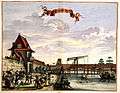 |
 |
| Bastion Middelburg (demolished) | Middelburg | 1627-1632[5] | anonymous | 6°07′51″S 106°48′55″E / 6.130719°S 106.815397°E | — |
 |
| Bastion Nassau (demolished) | Nassau | 1632-1635[5] | anonymous | 6°08′14″S 106°48′38″E / 6.137265°S 106.810689°E |  |
 |
| Bastion Oranje (demolished) | Oranje | 1627-1632[5] | anonymous | 6°08′15″S 106°48′52″E / 6.137377°S 106.814514°E | |
 |
| Bastion Overrijsel (demolished) | Overrijsel | 1632-1635[5] | anonymous | 6°07′47″S 106°48′20″E / 6.129746°S 106.805465°E | — |
 |
| Bastion Rotterdam (demolished) | Rotterdam | 1627-1632[5] | anonymous | 6°07′58″S 106°48′57″E / 6.132779°S 106.815928°E | |
 |
| Bastion Utrecht and portal (demolished) | Utrecht Poort | 1635-1650[5] | anonymous | 6°08′07″S 106°48′25″E / 6.135285°S 106.806872°E |  |
 |
| Bastion Vierkant (demolished) | Vierkant | 1627-1632[nb 1] | anonymous | 6°07′36″S 106°48′28″E / 6.126775°S 106.807857°E | — |
|
| Bastion Zeeburg (demolished) | Zeeburch poort | 1632-1635[5] | anonymous | 6°07′34″S 106°48′28″E / 6.126119°S 106.807639°E | — |
 |
| Bastion Zeeland (demolished) | Zeeland poort | 1627-1632[5] | anonymous | 6°08′16″S 106°48′28″E / 6.137890°S 106.807708°E | |
 |
| Batavia City Hall (1st) and church (demolished between 1622 and 1627.) | Kerk en Stadhuis | 1619-1622[5] | anonymous | 6°07′57″S 106°48′42″E / 6.132411°S 106.811770°E | — |
|
| Batavia City Hall (2nd) (replaced with Batavia City Hall (3rd)) | Batavia Stadhuis | 1627 | 6°08′07″S 106°48′48″E / 6.135348°S 106.813372°E | — |
 | |
| Binnenhospital, "Inner Hospital" (closed in 1808, demolished in 1910 for De Javasche Bank)[9] | Binnenhospital[4] | 1641[9] | anonymous | 6°08′14″S 106°48′46″E / 6.137185°S 106.812856°E | 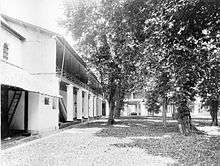 |
 |
| Chinese hospital and home for the aged (formally closed in 1912,[10] later demolished) | Sinees Sieken Huys | 1646[10] | anonymous | 6°08′05″S 106°48′27″E / 6.134812°S 106.807577°E[6] | — |
 |
| De Middelpunt, "the middle point" | De Middelpunt | 1650-1667[5] | anonymous | 6°08′03″S 106°48′40″E / 6.134163°S 106.811096°E[5] |  | |
| De Portugese Stadskerk (burned down in 1808)[11] | De Portugese Stadskerk, De Portugese Binnenkerk | 1650-1667,[5] 1669-1672[12] | — |
6°08′02″S 106°48′37″E / 6.133806°S 106.810358°E[5] | |
 |
| Fort Ancol (demolished) | Fort Zouteland, Schaans Zouteland[7] | 1656[13] | anonymous | 6°07′36″S 106°50′43″E / 6.126605°S 106.845150°E | — |
 |
| Fort Angke (demolished) | See Fort Anké | 1657[14] | anonymous | — |
 | |
| Fort Jacatra (Nassau and Mauritius) (dismantled between 1627–1632)[5] | Fort Jacatra | before 1619[5] | 6°07′43″S 106°48′36″E / 6.128640°S 106.809979°E | — |
||
| Fort Jacarta Buiten Batavia (demolished) | Fort Jacarta Buiten Batavia | anonymous | 6°08′43″S 106°49′50″E / 6.145389°S 106.830442°E | — |
 | |
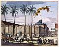
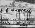
| Fort Meester Cornelis (demolished) | Fort Meester Cornelis | 1734 | anonymous | 6°12′05″S 106°51′00″E / 6.201325°S 106.850101°E |  |
 |
| Fort Noordwijk (demolished in 1808) | Fort Noordwijk[7] | 1658 | anonymous | 6°10′04″S 106°49′51″E / 6.167773°S 106.830801°E | — |
 |
| Fort Zevenhoek (demolished) | Fort Zevenhoek | 1657[14] | anonymous | — |
||
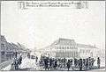
| Fort Rijswijk (abandoned in 1697, demolished in 1729)[15] | Fort Rijswijk[7] | August 1656[15] | anonymous | 6°10′03″S 106°49′08″E / 6.167574°S 106.818830°E |  |
 |
| Galangan VOC Restaurant and Ta San Yen | Carpenter's shop of the Dutch East Indies | 1627-1632[5] or before 1650[6] or 1727[16] | anonymous | 6°07′42″S 106°48′32″E / 6.128344°S 106.808937°E |  |
 |
| Gedung Candra Naya (1957)[17] | Landhuis Kroet / Landhuis Van Majoor der Chinezen Khouw Kim An or "residence of Chinese Mayor Khouw Kim An"[18] | 18th century[18] | Khouw Tjoen (first resident)[18] | 6°08′50″S 106°48′55″E / 6.147337°S 106.815284°E |  |
 |
| Gerbang Amsterdam or "Amsterdam Gate" (demolished in the 1950s) | Amsterdamsepoort, Pinangpoort, Kasteelpoort | 1744[19] | 6°07′51″S 106°48′43″E / 6.130834°S 106.812062°E |  |
 | |
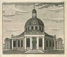
| Gereja Sion | De Portugese Buitenkerk | 1695[12] | E. Ewout Verhagen | 6°08′17″S 106°49′05″E / 6.138009°S 106.817920°E |  |
|
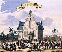
| Gereja Tugu | Portuguese Church | 1676–1678, rebuilt in 1737, and later in 1748. | Melchior Leidecker, later rebuilt by Julius Vinck[20] | 6°07′26″S 106°55′27″E / 6.123844°S 106.924070°E | ||
| Government House or a 'Playhouse' (demolished) | Huis van de Generaal/Speelhuis | 1632-1650[5][6] | anonymous | 6°08′31″S 106°48′55″E / 6.141976°S 106.815156°E | — |
|
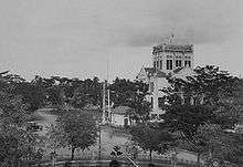
| Great Palace of Weltevreden (demolished in 1820, now Gatot Soebroto Army Hospital)[21][22] | Great Palace of Weltevreden / Landhuis Weltevreden[22] | 1761[21] | for Jacob Mossel[21][nb 2] | 6°10′36″S 106°50′12″E / 6.176726°S 106.836608°E | — |
 |
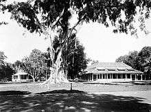
| Groeneveld (estate) | Tandjoeng Oost Huis, "Gedong Tinggi"[24][25] | 1756-1760[26] | Pieter van de Velde (first owner)[26] | 6°18′10″S 106°51′23″E / 6.302771°S 106.856292°E |  | |
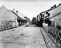
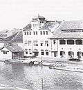
| Jembatan Gantung Kota Intan | Engelse Brug[27] / Het Middelpuntbrug[28] / Grote Boom or "Large Tree Bridge"[28] / Djembatan Hoenderpasser Kali Besar or Hoenderpasserbrug or "Chicken Market Bridge" (1900s)[27][28][29] / Ophaalbrug Juliana (1938)[28] | 1655 (after the demolition of earlier English Bridge, located 100 meter to the south),[5][27] 1937 (renovated)[28] | 6°07′53″S 106°48′38″E / 6.131259°S 106.810579°E |  |
_Batavia_TMnr_10014923.jpg) | |
| Kasteel Batavia | Kasteel Batavia | 1619[5] | anonymous | 6°07′40″S 106°48′41″E / 6.127854°S 106.811338°E |  |
 |
| Mesjid Luar Batang, Luar Batang Mosque | Mesjid Luar Batang | 1739 (established)[30] | Sayid Husein bin Abubakar Alaydrus (founder)[30] | 6°07′26″S 106°48′24″E / 6.123765°S 106.806533°E | _TMnr_60046455.jpg) | |
| Mohr Observatory (demolished in 1812) | Mohr Observatory | 1765 | Johan Maurits Mohr | 6°08′38″S 106°48′46″E / 6.143863°S 106.812911°E | 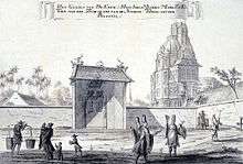 |
 |
| Museum Bahari | Warehouse | 1652–1771 | anonymous | 6°07′36″S 106°48′30″E / 6.126753°S 106.808279°E |  |
 |
| Museum Sejarah Jakarta | Batavia City Hall (3rd) | 1706-1710[31] | W.J. van der Velde | 6°08′07″S 106°48′48″E / 6.135348°S 106.813372°E |  |
 |
| Nieuwe Hollandse Kerk, "New Church of Holland" (destroyed by earthquake in 1808, Wayang Museum is now on its site) | Nieuwe Hollandse Kerk, Groote Hollandse Kerk | 1736 | 6°08′06″S 106°48′45″E / 6.134882°S 106.812603°E | |
 | |
| Nieuwe Poort, "New Gate" (demolished) | Nieuwe Poort | 1627-1632[5] | anonymous | 6°08′18″S 106°48′50″E / 6.138424°S 106.813777°E | | |
| Old Gelderland defence works (demolished after 1667)[5] | Oud Gelderland | 1622-1627[5] | anonymous | 6°08′06″S 106°48′56″E / 6.135031°S 106.815689°E | — |
|
| Oude Hollandse Kerk, "Old Holland Church" (demolished in 1732, bottom part still visible)[nb 3] | Oude Hollandse Kerk / Kruiskerk, "Cross Church" | 1640 | anonymous | 6°08′06″S 106°48′45″E / 6.134882°S 106.812603°E |  |
 |
| Oude Utrechtse Poort, "Old Utrecht Gate" (demolished) | Oude Utrechtse Poort[nb 4] | 1632-1650[5] | anonymous | 6°08′10″S 106°48′26″E / 6.136034°S 106.807207°E | — |
|
| Pasar Ikan, "Fish Market" | Vismarkt | anonymous |  |
 | ||
| Playhouse of Adriaan van Hafte | Playhouse of Adriaan van Hafte | 18th century | anonymous | Tanjung Priok | — |
|
| Raja Kuring Restaurant | Carpenter's shop of the Chinese | 1632-1635[5] | anonymous | 6°07′48″S 106°48′35″E / 6.130012°S 106.809692°E[6] | ||
| Spinhuis, "spinning-house for single women" (later merged with Chinese Hospital,[10] then demolished) | Spinhuis, Spinhuys | 1635-1650[5] | anonymous | 6°08′03″S 106°48′30″E / 6.134214°S 106.808318°E | — |
 |
| The Latin and Greek School (demolished)[2] | The Latin and Greek School | 1622-1627[5] | anonymous | 6°07′55″S 106°48′48″E / 6.131917°S 106.813228°E[5] | — |
 |
| Toko Merah | see Toko Merah | 1730[nb 5] | for Gustaaf Willem van Imhoff | 6°08′09″S 106°48′41″E / 6.135955°S 106.811285°E | 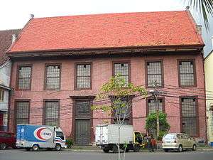 |
 |
| Vihara Dharma Bhakti | Jin De Yuan Klenteng | 1650, 1755 (restored)[33] | Kwee Hoen (Guo Xun-Gan)[33] | 6°08′38″S 106°48′46″E / 6.143973°S 106.812736°E | 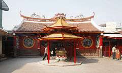 |
 |
| Vismarkt, "Fish Market" (earlier structure) (demolished) | Vismarkt, Vischmarkt | 1632-1635[5] | anonymous | 6°07′50″S 106°48′36″E / 6.130653°S 106.80995°E | 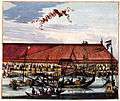 |
 |
| Waterkasteel (demolished) | Waterkasteel / "Hornwerk"[34] | 1741, 1750[35] | anonymous | 6°06′58″S 106°48′24″E / 6.116205°S 106.806601°E | — |
 |
| Wooden former office building at Kali Besar Timur (abandoned) | Various offices; Chinese shops (early 18th-century)[3] | early 18th-century[3] | anonymous | 6°08′06″S 106°48′43″E / 6.134928°S 106.811904°E | 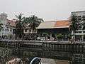 |
 |
Colonialism – late 18th century to 1870
After the VOC was formally dissolved in 1800 the Batavian Republic expanded all the VOC's territorial claims into a fully fledged colony named the Dutch East Indies. From the company's regional headquarters Batavia now evolved into the capital of the colony. In 1808 Daendels moved the old town center to higher ground to the south and urbanized the area known as Weltevreden. During the British interregnum Daendels was replaced by Raffles who governed until 1816.
As the Dutch become more securely established in the region, towns grew up beyond the walls of the fort.[2] Batavia, together with Semarang and Ujung Pandang, were the most important urban centers.[2] During this time, Batavia became congested and wealthier merchants and other powerful men began to build their residences on the outskirts of town and in the surrounding countryside.[2]
The period shows a gradual adaptation to the tropical climate form on the part of the Dutch colonial architecture. These new form of architecture is called Indische Stijl. Typical style during this period include large roof overhang, high roof and ceiling, and front and rear verandahs that opened on to gardens. Indies style can be described as a mix of Indonesian, Chinese, and European influence. Very often the local Javanese style limasan roof was employed, but with addition of 19th-century European architectural elements such as Tuscan columns, doors, windows, and a flight of three to four steps leading up to a verandah running the full width of the house.[2]
Neoclassicism was a popular style for buildings in Jakarta during this period, which is considered to be the best representation of the greatness of the empire.[36]
| Last official name | Former names | Year | Architect | Location | Latest image | Oldest image |
|---|---|---|---|---|---|---|
| Aley Cramerus Residence | anonymous | — |
 | |||
| C. Schultze Residence | anonymous | — |
 | |||
| H. Vaupel Residence | — |
 | ||||
| J.J. Kunst Residence | anonymous | — |
 | |||
| M.C. Westerman Residence | anonymous | — |
 | |||
| W.C. van Benthem Jutting Residence | anonymous | Kebon Sirih, Weltevreden | — |
 | ||
| All Saints Church | Engelsekerk, Gereja Inggris (original) / Church of the British Protestant Community (BPC) (1843) / All Saints Church (1950)[37] | 1828[37] | 6°11′00″S 106°50′06″E / 6.18335°S 106.835011°E | |||
| Armenian Church (demolished, now empty land near Bank Indonesia Thamrin building) | Armeensche kerk | 1831[38] | 6°10′51″S 106°49′21″E / 6.180893°S 106.822408°E | |||
| Asrama Polisi Sektor Pal Merah | Landhuis Kebayoran Lama / Gedung Tinggi or "tall building"[nb 6] / Rumah Grogol or "Grogol house" / Residence of Andreas Hartink | 18th century[39][40] | W.J. Van de Velde[39] | 6°12′26″S 106°47′22″E / 6.207208°S 106.789482°E | ||
| Balai Kota DKI Jakarta, "Jakarta City Hall" | Burgemeesterswoning / Jakarta Tokubetsusi (1942–1945) | 19th century[41] | anonymous | 6°10′52″S 106°49′44″E / 6.181220°S 106.828964°E | ||
| Biara Santa Ursula, Kapel, dan Sekolah Santa Ursula; "St Ursula cloister, chapel, and school" | Ursulinen Klooster, "Kleine Klooster"[42] | 1859 (cloister), 1888 (chapel), 1912 (school) | anonymous | 6°10′07″S 106°50′03″E / 6.168618°S 106.834143°E |  |
 |
| Carl Schlieper Gebouw (destroyed by fire on December 17, 1920, on its site was built de Factorij. | Carl Schlieper Gebouw | Late 19th-century | 6°08′17″S 106°48′47″E / 6.138170°S 106.813085°E |  | ||
| Café Batavia (1991)[43] | Dutch colonial government office building[43] / art gallery (1990)[43] | 1837[43] | 6°08′04″S 106°48′46″E / 6.134410°S 106.812740°E | 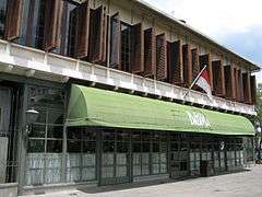 |
||
| Church of Saint Mary Ascend to Heaven (1st form) (renovated in 1859) | De Kerk van Onze Lieve Vrowe ten Hemelopneming (original) | November 6, 1829 (inauguration) | Monseigneur Prinsen (inaugurated) | 6°10′08″S 106°49′59″E / 6.169013°S 106.833114°E | ||
| Church of Saint Mary Ascend to Heaven (2nd form) (collapsed in 1890) | De Kerk van Onze Lieve Vrowe ten Hemelopneming (original) | 1859 (renovation of the earlier form) | 6°10′08″S 106°49′59″E / 6.169013°S 106.833114°E | |||
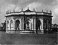
| Citadel Prins Frederik (demolished, on its site stands the Istiqlal Mosque, Jakarta) | Citadel Prins Frederik[4] | 1831[4] | 6°10′13″S 106°49′51″E / 6.170386°S 106.830742°E |  |
_TMnr_10015199.jpg) | |
| De Club Burger Societeit (demolished) | Residence (1815, 1819) / Hotel Marine (1833)[44] | 1815 | 6°10′03″S 106°49′13″E / 6.167613°S 106.820352°E | 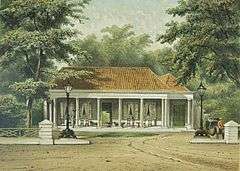 | ||
| Dewan Kerajinan Nasional (February 24, 1992)[45] | Residence / Office of Hamengkubuwono IX (1945)[45] | 1860–1870[45] | anonymous | Jl. Prapatan No. 42 Kel. Senen, Kec. Senen, Jakarta 10410[45] | ||
| Galeri Nasional Indonesia | See National Gallery of Indonesia | 1817 | G.C. van Rijk (commissioner?) | 6°10′43″S 106°50′00″E / 6.178529°S 106.833276°E |  |
|
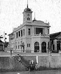
| Gedung A.A. Maramis | Palace of Governor-General Daendels / Het Groote Huis / Het Witte Huis[nb 7] | March 7, 1809[46] | J.C. Schultze, completed by J. Tromp (1828)[46] | 6°10′09″S 106°50′14″E / 6.169257°S 106.837096°E | 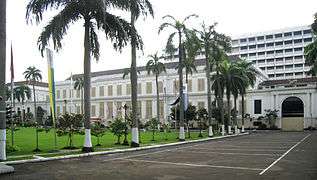 |
 |
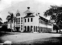
| Gedung Kawedri (1987)[47] | TNI AD Department of Health[48] / TNI Batalyon Kala Hitam headquarter (1949)[48] / Netherlands/Japanese/Allied Civil Defense Department (1942-1949)[48] / Hogere Burger School (1867)[48]/ Gymnasium Koning Willem III School te Batavia (original)[48] | 1860 (school established)[48] | anonymous | 6°11′56″S 106°51′07″E / 6.198758°S 106.85183°E |  |
 |
| Gedung Kesenian Jakarta | Stadtsschouwburg / Bataviasch Schouwburg / "Gedung Komidi" / Sin'tsu Cekizyoo[49] | 1821[nb 8] | J.C. Schultze | 6°10′00″S 106°50′04″E / 6.166540°S 106.834417°E | 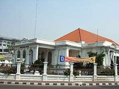 |
 |
| Gedung Pancasila, Pancasila Building[50] / Gedung Departemen Luar Negeri or Building of the Ministry of Foreign Affairs[51] | Residence of Hertog Bernhard (original)[50] / residence of Dutch Royal Army Commander / Volksraad or Council of the Indies Building or Raad van Indië (1918) / Dokuritsu Zyunbi Tyoosakai or Badan Penyidik Usaha-Usaha Persiapan Kemerdekaan[51] | 1830[51] | J. Tromp[51] | 6°10′28″S 106°50′01″E / 6.174350°S 106.833632°E |  |
 |
| Gereja Immanuel, "Emmanuel Church" | Willemskerk or "Williams Church" | 1835–1839 | J.H. Horst | 6°10′36″S 106°49′55″E / 6.176703°S 106.832081°E |  |
 |
| Grand Hôtel Java (Demolished in the 1950s and replaced with Markas besar TNI Angkatan Darat (headquarters of the National Indonesian Army Land Forces))[52] | Private residence (original)[52] / Grand Hôtel Java (1834) | early 19th century | anonymous | 6°10′06″S 106°49′42″E / 6.168221°S 106.828216°E |  |
 |
| Hotel der Nederlanden (demolished and replaced with Bina Graha Presidential Office in 1969)[53][54] | Pieter Tenzy residence (original)[53] / W.H. van Eijsseldijk residence[53] / Thomas Stamford Raffles residence (1811)[53] / Hotel Palace Royale (1840)[53] / Hotel der Nederlanden (1846)[53] / Hotel Dharma Nirmala (1950s)[54] / Markas Cakrabirawa (1950s)[54] | 1794[54] | ? | 6°10′05″S 106°49′30″E / 6.167956°S 106.824918°E |  |
 |
| Hotel des Indes 1st form (renovated in 1930)[55] | a residential / Hotel Chaulan (1828)[nb 9] / Hotel de Provence (1835) / Hotel Rotterdamsch (1854) / Hotel des Indes (1 May 1856) | 1930 | ? | 6°09′56″S 106°49′11″E / 6.165495°S 106.819806°E |  |
 |
| Hotel Sriwijaya (1950)[56] | Hotel Cavadino (1863) / Hotel Lion d’Or (1899) / Park Hotel (1941)[56] | 1863 | for Conrad Alexander Willem Cavadino | 6°10′08″S 106°49′47″E / 6.168918°S 106.829860°E | ||
| Hotel Wisse (1891, replaced with Hotel des Galeries in 1920) | Residence of Governor-General Petrus Albertus van der Parra / Hotel Ernst (1860-1891)[57] | around 1750 | for Governor-General Petrus Albertus van der Parra | 6°10′01″S 106°49′16″E / 6.166930°S 106.821007°E |  | |
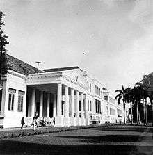
| Istana Merdeka | Governor General's Palace or Paleis van de Gouverneur-Generaal, "Gambir Palace" | 1873 | Drossares | 6°10′13″S 106°49′27″E / 6.170170°S 106.824177°E |  |
 |
| Istana Negara (1949) | Residence of Jacob Andries van Braam (original); Schonburg Building; Paleis Z. E. Gouverneur Generaal te Rijswijk | 1796–1804, 1848 (renovated after an earthquake)[58] | ? | 6°10′05″S 106°49′26″E / 6.168084°S 106.823956°E |  |
 |
| Jakarta West Mole[59] | Vuurtoren Batavia | 1862 | anonymous | 6°06′18″S 106°48′19″E / 6.105129°S 106.805397°E |  | |
| Jean Belle Residence (demolished, replaced with Nederlandsche Handels Maatschappij te Weltevreden in 1910)[60] | Jean Belle Residence[60] | anonymous | ||||
| J.P. Coen Statue (demolished on March 7, 1943 during Japanese occupation)[61] | J.P. Coen Statue | 1869[61] | anonymous | 6°10′10″S 106°50′13″E / 6.169353°S 106.836808°E |  |
 |
| Kimia Farma at Jalan Budi Utomo | Loge nummer 14: ‘De Ster in het Oosten’;[62] Rathkamp Apotheek (early 20th century);[63] "Gedung Setan"[63] | 1837 (established),[64] 1858? (probably the date of the building)[62] | anonymous | 6°10′04″S 106°50′09″E / 6.167657°S 106.835955°E |  | |
| Kimia Farma at Jalan Veteran | Volksapotheek te Rijswijk[65] | 1857; 1913 (renovated) | anonymous; Eduard Cuypers (renovation) | 6°10′05″S 106°49′36″E / 6.168194°S 106.826802°E | ||
| Kleedingmagazijn M. De Koning in Noordwijk (Demolished in the 1950s, now Grand Brilliant Palace Restaurant) | Kleedingmagazijn M. De Koning in Noordwijk[66] | anonymous | 6°10′02″S 106°49′39″E / 6.167146°S 106.827491°E | |||
| Magazijn Onderlinge Hulp in Noordwijk (demolished, replaced with Kantor Departemen Keuangan RI bagian KPPN (Kantor Pelayanan Perbendaharaan Negara)) | Magazijn Onderlinge Hulp in Noordwijk[66] | anonymous | 6°10′01″S 106°49′37″E / 6.167054°S 106.827050°E | |||
| Mahkamah Agung or "Indonesia Supreme Court Building" | Hooggerechsgebouw | 1828 | J.C. Schultze, completed by J. Tromp (1828)[46][67] | 6°10′06″S 106°50′12″E / 6.168203°S 106.836664°E |  |
 |
| Menara Syahbandar | De Uitkijk | 1839[68] | anonymous | 6°07′39″S 106°48′33″E / 6.127527°S 106.809071°E | 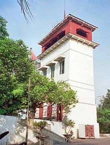 |
 |
| Mesjid Jami Kebon Jeruk or "Kebon Jeruk Mosque" | 1786[69] | for Tuan Tschoa (Kapten Tamien Dosol Seeng)[69] | 6°09′20″S 106°49′07″E / 6.155555°S 106.818506°E | |||
| De Militaire School te Meester Cornelis, Military School at Meester Cornelis (closed in 1892, demolished. Now stands the Army Department of Research and Development) | De Militaire School te Meester Cornelis | 1852 (opened) | 6°12′33″S 106°51′36″E / 6.209288°S 106.860127°E | 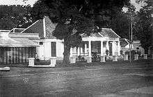 |
 | |
| Military Society Concordia (demolished in the 1960s, now occupied by Gedung A.A. Maramis II Departemen Keuangan) | Military Society Concordia / Kantor Pusar DPR[70] | 21 September 1833 (inauguration); 1836, 1874, 1990 (building extension) | ? | 6°10′13″S 106°50′16″E / 6.170186°S 106.837689°E |  | |
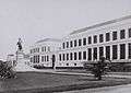
| Museum Nasional, "Museum Gajah" | Bataviaasch Genootschap van Kunsten en Watenschappen, "The Batavian Society of Arts and Science Building"[71] | 1862 | ? | 6°10′35″S 106°49′20″E / 6.176434°S 106.822115°E |  |
 |
| Museum Seni Rupa dan Keramik | Palais van Justitie ("Justice Palace") | 1870 | ? | 6°08′04″S 106°48′51″E / 6.134310°S 106.814212°E |  |
 |
| Museum Sumpah Pemuda | Customs inspection office / Hotel Hersia (until 1951) / Residence (1937–1951) / Sie Kok Liong's Dormitory for students from outside Java (before 1928)[72] | before 1925 | anonymous |  |
||
| Museum Tekstil (1978) | Residence; Headquarter of Barisan Keamanan Rakyat ("Front of People Safety"); Institution for aged people (1947) | 19th century | anonymous | 6°11′17″S 106°48′35″E / 6.188019°S 106.809620°E | 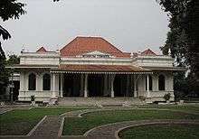 |
|
| Office (building collapsed because of structural failure in 2015, demolished) | NV Koninklijke Boekhandel en Drukkerij G Kolff & Co (1860-1921)[73][74] | Before 1860 | anonymous | 6°08′03″S 106°48′43″E / 6.134228°S 106.811806°E |  |
 |
| Oger Frères[75] (demolished, replaced with Singer Building in the 1930s) | Oger Frères | 1823 (store opened) | anonymous | 6°10′05″S 106°49′15″E / 6.168118°S 106.820704°E |  |
 |
| Oude Katholieke Kerk, "Old Catholic Church" (demolished in 1830) | before 1821 | anonymous | Weltevreden |  | ||
| Passer Baroe, Pasar Baru | Passer Baroe | 1821[76] | — |
6°09′55″S 106°50′05″E / 6.165375°S 106.834602°E | 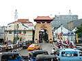 |
 |
| Percetakan Negara Republik Indonesia, "Indonesian Republic State Printing" ()[77] | Landsdrukkerij (original); Gunseikanbu Inatsu Kojo or GIK (1942-1945); Percetakan Republik Indonesia (1950) | anonymous | 6°11′26″S 106°51′23″E / 6.190694°S 106.856492°E | 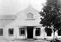 |
 | |
| Perpustakaan Nasional Indonesia at Jalan Medan Merdeka Selatan | 6°10′52″S 106°49′37″E / 6.1811°S 106.826916°E | 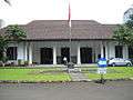 |
||||
| Photographisch Atelier Walter Woodbury (demolished, replaced by Gedung Bina Graha) | Residence of Van Dorp (original) / Photographisch Atelier Walter Woodbury (1861–1908)[78] | before 1861 | anonymous | 6°10′04″S 106°49′31″E / 6.167701°S 106.825144°E |  |
 |
| Post- en Telegraafkantoor te Weltevreden | Post- en Telegraafkantoor te Weltevreden | before 1880 | anonymous | Postweg (now Jalan Pos) |  |
 |
| Postkantoor Weltevreden (demolished and replaced with a new building in 1913) | Postkantoor Weltevreden | 1853 | anonymous | |||
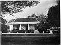
| Rumah Cililitan Besar (deteriorated, occupied by squatters) | Landhuis Tjililitan | 1775 | Hendrik van der Crap (owner) | 6°16′08″S 106°52′15″E / 6.268915°S 106.87073°E |  | |
| Rumah Sakit Cikini or "Cikini hospital" | Raden Saleh Residence (original); Hospital and a Nurse Academy (1898)[79] | 1852 | Raden Saleh | 6°11′28″S 106°50′28″E / 6.191153°S 106.841235°E |  |
 |
| SKAHA (first floor) | Assurantiekantoor Langeveldt – Schröder; Goedang Kakaco (Kerkhoff, Kerstholt & Co., Importeurs)[3] | 19th century? | anonymous | 6°08′12″S 106°48′44″E / 6.136590°S 106.812355°E |  |
 |
| SMK Santa Maria | Groote Klooster[42] / Mater Dei (1920)[80] | 1856[80] | anonymous | |||
| Societeit Harmonie or "Harmony Society (Batavia, Dutch East Indies)" (demolished for road widening and parking area in 1985)[81] | Societeit Harmonie | 18 January 1815[nb 10] | J.C. Schultze | 6°10′05″S 106°49′16″E / 6.167927°S 106.821246°E |  |
 |
| Topografische Dienst te Weltevreden | Topografische Dienst te Weltevreden | anonymous |  | |||
| Villa Nova | Villa Nova | Before 1870[82] | anonymous | |||
| Wilhelmina Exposition Pavilion (demolished) | Wilhelmina Exposition Pavilion, Wilhelminapaviljoen | before 1880 | anonymous | 6°10′12″S 106°50′13″E / 6.170018°S 106.836928°E |  |
 |
| Zoological and Plant Society Main Building (demolished) | Zoological and Plant Society Main Building |  |
Post Cultuurstelsel abolition – 1870 to mid 20th century
The abolition of the Cultuurstelsel in 1870 made way for the rapid development of private enterprises in the Dutch Indies. Numerous trading companies and financial institutions established themselves in Java, most of them settled in Batavia. Jakarta Old Town's deteriorating structures were replaced with offices, typically along the Kali Besar. These private companies owned or managed plantations, oil fields, and mines. Railway stations were designed during this period, with characteristic style of this period.[2]
Architecturally, neoclassicism fell out of favor to be replaced by Neogothic and Dutch Rationalism. Apparent architectural style were Nieuwe Kunst (e.g. Bank Tabungan Negara), Art Deco or De Stijl, and Amsterdam School. This architecture styles were also the tropical counterpart of the original style, resulting in a style called New Indies Style.
Two dominant architectural bureaus during this period were AIA Bureau (Frans Ghijsels) and AA Fermont and Cuypers Bureau (Eduard Cuypers).[2]
Colonnades are required during this period to provide protection against monsoon rains and tropical sun, which in turn transformed the appearance of buildings in the city centers.[2]
Colonial style in Jakarta lingered some years after the Japanese occupation of Indonesia in 1942, and further after the independence of Indonesia in 1945.
| Last official name | Former names | Year | Architect | Location | Latest image | Oldest image |
|---|---|---|---|---|---|---|
| Bioscoop Manggarai or "Manggarai Cinema" | ||||||
| Binnacle (Schakelhuis) |  | |||||
| Frans Consulaat Koningsplein |  | |||||
| Electrification of the State Railway Company at Meester Cornelis (Electrificatie van de Staatsspoor- en Tramwegen (SS en T) bij het spoorwegstation te Meester Cornelis) | _bij_het_spoorwegstation_te_Meester_Cornelis_in_Batavia_TMnr_10014015.jpg) | |||||
| Kantoor van de Nederlandsch Indische Escompto Maatschappij te Weltevreden | 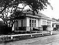 | |||||
| Laboratory for Pasar Ikan Marine Research | _TMnr_60016934.jpg) | |||||
| Modernist villas of Westerpark | 1920-1930s | 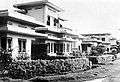 | ||||
| Van Arcken and Co. Shop |  | |||||
| Algemeen Delisch Emigratie Kantoor (A.D.E.K.), "General Deli Emigration Office" (demolished, now Inkoppol) | Algemeen Delisch Emigratie Kantoor; internment camp ADEK(1942-1944); Bunsho I Kamp 8 (1944-1945); Relief camp (1945-1946)[83] | 1920s? | anonymous | 6°12′14″S 106°50′55″E / 6.203975°S 106.848706°E | _in_Bandoeng_TMnr_60014032.jpg) | |
| Artesian well at Batoe Toelis (demolished) | Artesian well at Batoe Toelis |  | ||||
| Artesian well at Koningsplein (demolished) | Artesian well at Koningsplein | 6°10′18″S 106°49′32″E / 6.171693°S 106.825636°E[84] | 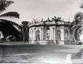 |
 | ||
| Artesian well at Meester Cornelis (demolished) | Artesian well at Meester Cornelis | 1881 | Meester Cornelis | 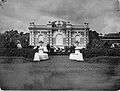 | ||
| Artesian well at Postweg (demolished) | Artesian well at Postweg |  | ||||
| Artesian well at Salemba (Demolished) | Artesian well at Salemba | 6°11′37″S 106°51′00″E / 6.193574°S 106.849935°E[84] |  | |||
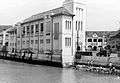
| Asuransi Jasa Indonesia | West Java Handel Maatschappij[85] | 1912[86] | AA Fermont and Cuypers Bureau | 6°08′03″S 106°48′46″E / 6.134176°S 106.812882°E |  |
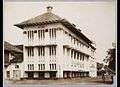 |
| Asuransi Jasa Indonesia | De Nederlanden van 1845 (original)[87][88] | 1913[87][88] | Hendrik Petrus Berlage[87] | 6°08′12″S 106°48′48″E / 6.136561°S 106.813296°E | ||
| Asuransi Jiwasraya (1957, original front facade has been demolished for road widening. In 2016, the original front facade was recreated, however in a clumsy style.)[89] | Nillmij (Nederlandsch-Indische Levensverzekerings en Lijfrente Maatschappij) | 1909–1910[90] | P.A.J. Moojen and S. Snuyft[90] | 6°10′01″S 106°49′24″E / 6.166923°S 106.823224°E |  | |
| Asuransi Wahana Tata, Wahana Tata Insurance | Office | 19th century[91] | unknown | 6°08′06″S 106°48′40″E / 6.134973°S 106.811088°E |  |
|
| Badan Pengawas Tenaga Nuklir (BAPETEN), "Nuclear Energy Regulatory Agency" | Gebouw van Burgerlijke Openbare Werken,[92] Department of Public Works[93] | before 1920[93] | 6°09′50″S 106°49′11″E / 6.163912°S 106.819607°E | 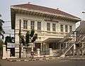 |
||
| Bahtera Jaya Ancol | Jachtclub Tandjong Priok[94] / Koninklijke Bataviasche Jachtclub / Kodja Bataviasche Yacht Club / Badan Keamanan Rakyat Laut headquarter[95] | 1926[96][94] | anonymous | 6°06′44″S 106°51′50″E / 6.11211°S 106.863767°E |  |
 |
| Bank Mandiri | Kantoor van de Nederlandsch Indische Escompto Maatschappij / Bank Dagang Negara / Bank Mandiri | 1920 | Eduard Cuypers and M.J. Hulswit | 6°08′11″S 106°48′46″E / 6.136417°S 106.812845°E |  |
 |
| Bank Mandiri | Standard Chartered Bank Office of India, Australia, and China / Bank Umum Negara (1965)[97] / Bank Bumi Daya (1968)[97] | February 27, 1921[97] | Eduard Cuypers and M.J. Hulswit | 6°08′12″S 106°48′41″E / 6.136532°S 106.811417°E |  |
 |
| Bank Mandiri - Jakarta-Kota branch | Bank Export Import / Bank Bumi Daya (1960) / Nederlandsch-Indische Handelsbank (1940) | April 1937 (start), 25 May 1940 (opened)[98] | Ir. J.F.L. Blankenberg, Wolff Schoemaker,[99] | 6°08′13″S 106°48′49″E / 6.137011°S 106.813704°E |  |
|
| Bank Sinarmas | NV. Handelsvereniging / NV. Reiss & Co[100] | 19th century?[101] | 6°08′09″S 106°48′41″E / 6.135787°S 106.811279°E |  |
 | |
| Bank Tabungan Negara Office (1968)[102] | Kantoor van de Postspaarbank (1920)[102] / Tyokin Kyoku (1942)[102] / Bank Tabungan Pos (1945)[103] | 1920, 1936 (renovated to current form)[102] | RLA Schoenmaker (1920), J. van Gendt (1936)[102] | 6°10′02″S 106°49′13″E / 6.167185°S 106.820338°E |  |
 |
| Banteng Building - Kantor Advokat dan Pengacara | N.V. Gebr. Sutorius & Co. Handel Maatschappij (before 1932)[3] | 19th century[3][104] | anonymous | 6°08′10″S 106°48′41″E / 6.136108°S 106.811337°E |  |
|
| Bappenas or "Board of National Planning and Development" | Loge "Adhuc Stat",[64][105] 1858? (probably the date of the building)[62] | 1925[105][106] | Frans Ghijsels (AIA Bureau)[106] | 6°12′02″S 106°49′57″E / 6.200663°S 106.832426°E | ||
| Bataviaasch Nieuwsblad (demolished) | Bataviaasch Nieuwsblad newspaper | 1927[107] | Frans Ghijsels | Jalan Pintu Air |  | |
| Bengkel Praktek Kerja Pendidikan Teknik (1974)[108] | Nederlandsch Indie Gas Maatschappij | 1924 | Jl. Budi Utomo No. 3 Kel. Pasar Baru Kec. Sawah Besar Jakarta 10710 | |||
| Bhanda Graha Reksa | Offices[nb 11] | 1922-1923[3] | Van den Berg en Pichel[3] | 6°08′10″S 106°48′44″E / 6.136135°S 106.812264°E |  |
 |
| Bioscoop Menteng (demolished in 1988, on its site stands Menteng Plaza)[110] | Bioscoop Menteng | 1949[110]-1950 (opened)[111] | Han Groenewegen (Selle, De Bruyn, Reyerse & de Vries)[110] | 6°11′00″S 106°50′03″E / 6.183443°S 106.834165°E |  | |
| BP7 | Volksraad or Council of the Indies Building or Raad van Indië (1918) / Dokuritsu Zyunbi Tyoosakai or Badan Penyidik Usaha-Usaha Persiapan Kemerdekaan[36] | 1927[112] | E. Kühr[112][113] | 6°10′31″S 106°49′59″E / 6.175200°S 106.833073°E |  |
 |
| Building at Jl. Kunir no. 2[114] | Geo. Wehry & Co Office building | 1925-1928[3] | A.I.A[3][115] | 6°07′57″S 106°48′53″E / 6.132514°S 106.814826°E |  |
 |
| Canisius College | Canisius College AMS | 1927 | a group of Jesuit pastors (established) | 6°11′09″S 106°50′03″E / 6.185809°S 106.834284°E |  |
|
| Cipta Niaga | Zee en Brand Assurantie[116] / Gebouw van de Internationale Credit en Handelsvereeniging Rotterdam[117] / Tjipta Niaga | 25 May 1912[116][117] | Eduard Cuypers, Hulswit[116] | 6°08′04″S 106°48′43″E / 6.134519°S 106.811900°E |  |
 |
| Departemen Energi dan Sumber Daya Mineral, "Department of Energy and Mineral Resources" | Batavia Police Headquarter[101] | 1925 (approximate)[101] | 6°10′53″S 106°49′25″E / 6.181321°S 106.823529°E | |||
| Département Keuangan, "Department of Monetary" | Ika-Daigaku Dormitory[118] | 1942[118] | Jl. Prapatan No. 10, Kel. Senen, Kec. Senen, Jakarta 10410 | |||
| Departemen Pertahanan dan Keamanan, "Department of Defense and Security" (1964)[119] | Rechts Hoge School[119] | 1924[119] | J.F. van Hoytema[119] | 6°10′38″S 106°49′19″E / 6.177091°S 106.821867°E | ||
| Djakarta Lloyd Office (abandoned)[120] | Asurantie Kantoor van Ongevallen verzekering mij FATUM en Onderlinge elvensverzekering van EIGEN HULP / Honda (2004)[121] | 1890 | 6°08′03″S 106°48′45″E / 6.134077°S 106.812596°E |  |
 | |
| Eigen Hulp aan de Molenvliet West (replaced with Postspaarbank office in 1920)[102] | Eigen Hulp aan de Molenvliet West | 1897[102] | 6°10′02″S 106°49′13″E / 6.167185°S 106.820338°E |  | ||
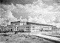
| Fakultas Kedokteran Universitas Indonesia, "Medical Faculty of the University of Indonesia" | de Geneeskundige Hoogeschool, "Medical College"[122] / School Tot Opleiding Van Inlandse Artsen (STOVIA)[106] | 1919-1926[122] | Dienst B.O.W./H. von Essen[106] | 6°11′42″S 106°50′56″E / 6.194962°S 106.848907°E |  |
 |
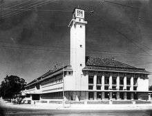
| Filateli Jakarta | Main Post and Telegraph Office | 1913[123] | J.F. van Hoytema[123] | 6°10′02″S 106°50′02″E / 6.167137°S 106.833818°E | 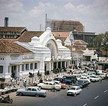 |
 |
| Former office of Nederlandsch Indische Handelsbank (NIHB) | First office of Nederlandsch Indische Handelsbank (NIHB) | 6°07′59″S 106°48′38″E / 6.133186°S 106.810616°E |  |
 | ||
| Galeri Melaka, PT Perusahaan Perdagangan Indonesia | N.V. Trading Company Deli - Aceh; Previously Borneo Company | 1923 | Eduard Cuypers and Hulswit | 6°08′13″S 106°48′37″E / 6.137014°S 106.810401°E | 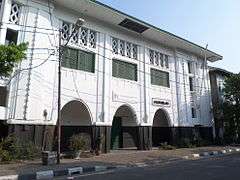 |
.jpg) |
| Galeri Nasional Indonesia, Gedung B | Bataviaasch Lyceum (See National Gallery of Indonesia) | 1902[32] | anonymous | 6°10′41″S 106°49′58″E / 6.178118°S 106.832667°E |  | |
| Gebouw van de Koninklijke Paketvaart-Maatschappij (KPM) bij de Sluisbrug (Demolished for road widening) | Gebouw van de Koninklijke Paketvaart-Maatschappij (KPM) bij de Sluisbrug | 1888 | 6°10′04″S 106°49′53″E / 6.167754°S 106.831296°E | _bij_de_Sluisbrug_Batavia_TMnr_60025925.jpg) | ||
| GKI Kwitang | Gereformeerde Kerk Kwitang | 1924 | 6°10′53″S 106°50′19″E / 6.181490°S 106.838501°E | |||
| Perusahaan Listrik Negara, State Electricity Company | Kantoor van Nederlandsch Indie Gas Maatschappij (1897)[124] | 1897 | 6°10′50″S 106°49′58″E / 6.180478°S 106.832777°E | |||
| Kementerian Dalam Negeri, The Ministry of Home Affairs (demolished after 1960) | Binnelands Bestuur | 1912-1915[123] | J.F. van Hoytema[123] | 6°10′09″S 106°49′42″E / 6.169078°S 106.828342°E | ||
| Kementerian Koordinator Bidang Pembangunan Manusia dan Kebudayaan Republik Indonesia, Coordinating Ministry for Human Development and Culture of the Republic of Indonesia | Passagekantoor van de Rotterdamse Lloyd en de Stoomvaart Maatschappij Nederland[125] | 1930s | 6°10′20″S 106°49′21″E / 6.172329°S 106.822381°E | |||
| Gereja Katedral Jakarta (final form) | De Kerk van Onze Lieve Vrowe ten Hemelopneming (original) | 1901 | Antonius Dijkmans, MJ Hulswit | 6°10′08″S 106°49′59″E / 6.169013°S 106.833114°E | 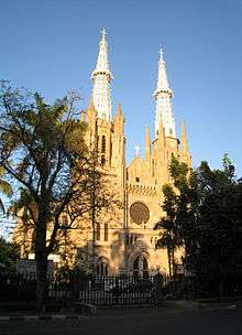 |
 |
| Gereja Koinonia | GPIB Bethel Jemaat Djatinegara (1961) / Bethelkerk (original)[126] | March 28, 1889[126] | 6°12′50″S 106°51′43″E / 6.213764°S 106.861818°E |  | ||
| Gereja Pniel (1953) | "Gereja Ayam" ("Chicken Church") / Haantjes Kerk[127] | 1913-1915 (replacing earlier church built in 1850) | N.A. Hulswit (Cuypers en Hulswit) | 6°09′39″S 106°50′03″E / 6.160909°S 106.834265°E |  |
|
| Gereja St Paulus (October 31, 1948) | See St. Paul's Church, Jakarta | 1936[128] | Frans Ghijsels (AIA Bureau)[128] | 6°12′02″S 106°49′53″E / 6.200499°S 106.831460°E | 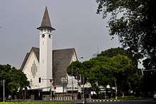 |
 |
| Gereja St Yoseph Matraman, "St. Joseph's Church" | St. Joseph Church Matraman | 1906 – June 22, 1909[129] or 1924[130] | Frans Ghijsels (AIA Bureau);[130] Ir Erawan Kartawidjaja (renovation in 2001) | 6°12′30″S 106°51′35″E / 6.208243°S 106.859596°E |  |
 |
| Gereja St Theresia, "St. Theresia's Church" | Theresiakerk | 1934[131] | Fermont-Cuypers Burean, Arsitek Th. van Oyen[131] | 6°11′20″S 106°49′32″E / 6.188929°S 106.825490°E | 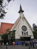 |
 |
| GKI Pinangsia, "Pinangsia Church" | Geredja Keristen Tionghoa | 11 April 1952 (opening)[132] | 6°08′27″S 106°48′59″E / 6.140808°S 106.816266°E |  | ||
| Pasar Glodok main building | Hoofdgebouw Pasar Glodok | 1920[133] | B.J.K. Cramer[133] | 6°08′35″S 106°48′52″E / 6.142926°S 106.814401°E | .jpg) | |
| Hotel Duta Indonesia (demolished in 1972, replaced with Duta Merlin Plaza)[55] | Hotel des Indes | 1930 | Burhoven Jaspers[55] | 6°09′56″S 106°49′11″E / 6.165495°S 106.819806°E |  |
 |
| Hotel Melati | Hotel des Galeries | 1914 | anonymous | 6°10′01″S 106°49′16″E / 6.166930°S 106.821007°E |  | |
| Jasa Raharja | Zee en Brand Verzekerings Maatschapij Sluyters & Co / Assurantiekantoor Blom & Van der Aa, Assurantiekantoor Combinatie Sluyters & Co, and de Java-China-Japan Lijn.[3] / Lloyd Insurance (1950)[134] | around 1911[3] | anonymous | 6°08′08″S 106°48′44″E / 6.135694°S 106.812086°E | 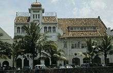 |
 |
| Kantor Pelayanan Pajak Jakarta Tambora, "Tambora Tax Office" | HSBC[100] | 1910-1911[3] | Following plan of Eduard Cuypers and Hulswit | 6°08′08″S 106°48′40″E / 6.135680°S 106.811241°E |  |
|
| Kantor Pos Cikini, "Cikini Post Office" | Tjikini post kantoor | Before the 1920s | anonymous | 6°11′14″S 106°50′12″E / 6.187273°S 106.836711°E |  |
 |
| Kantor Pos Kota, "Kota Post Office" | Post- en telegraaf kantoor aan het Stadhuisplein | 1929[106] | R. Baumgartner[106] | 6°08′02″S 106°48′48″E / 6.134022°S 106.813279°E | 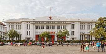 |
 |
| Kerta Niaga (1966)[135] | N.V. Borneo Sumatra Trading Company; MUCH: Maatschappij voor Uitvoer en Commissiehandel.[3] | 1915[3] | Eduard Cuypers and Hulswit[3] | 6°08′09″S 106°48′44″E / 6.135830°S 106.812145°E | 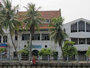 |
|
| Komite Nasional Keselamatan Transportasi - Departemen Perhubungan, "National Committee on Sea Transportation Safety, Ministry of Transportation" | Koninklijke Paketvaart-Maatschappij (original) / Japanese Marine Department (1942) | 1916–1918[136] | Frans Ghijsels (AIA Bureau)[136] | 6°10′30″S 106°49′51″E / 6.174917°S 106.830969°E |  | |
| Kunstkring Art Gallery | Bataviasche Kunstkring.
see Kunstkring Art Gallery |
1913 | P.A.J. Moojen | 6°11′20″S 106°50′01″E / 6.188898°S 106.833497°E |  |
.jpg) |
| Lembaga Biologi Molekul Eijkman, "Eijkman Institute of Molecular Biology"[137] | Eijkman Instituut | 1914 (built), 1916 (inauguration)[138] | H von Essen[138] | 6°11′53″S 106°50′47″E / 6.198011°S 106.846399°E |  |
 |
| Lembaga Pendidikan Jurnalistik Antara, "Antara Institute of Journalism" | see Gedung Antara | before 1923 | 6°09′57″S 106°50′02″E / 6.165816°S 106.833924°E | 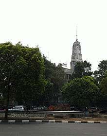 |
 | |
| Mesjid Cut Mutiah (1987) | N.V. de Bouwploeg (original) / post office, Train Company (1942–1945) / office of Home and Religion (1964–1970). | 1922 | P.A.J. Moojen | 6°11′14″S 106°50′00″E / 6.187285°S 106.833358°E |  |
 |
| Metropole | Bioscoop Metropol / Megaria | 1932 | Liauw Goan Sing | 6°12′00″S 106°50′37″E / 6.200059°S 106.843688°E | 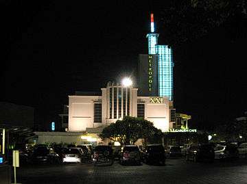 |
 |
| Michiels Monument (demolished between 1942–1945)[139] | Michiels Monument | mid 19th century | 6°10′16″S 106°50′00″E / 6.171074°S 106.833451°E |  |
 | |
| Monument voor de Slag bij Waterloo (demolished) | Monument voor de Slag bij Waterloo |  | ||||
| Monument for J.B. van Heutsz (demolished in 1960) | Monument for J.B. van Heutsz | 1927-1932[140] | 6°11′13″S 106°50′03″E / 6.186994°S 106.834119°E | 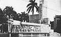 |
 | |
| Museum Joang '45 (1975)[141] | Hotel Schomper[141] / Ganseikanbu Sendenbu (1942–1945) / Asrama Angkatan Baroe Indonesia / Gedung Menteng 31 | 1920s[141] | 6°11′10″S 106°50′12″E / 6.186098°S 106.836601°E | |||
| Museum Kebangkitan Nasional, "Museum of the History of National Awakening" | STOVIA[122] | 1899-1902[122] | 6°10′43″S 106°50′17″E / 6.178718°S 106.838034°E |  | ||
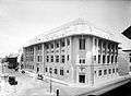
| Museum Bank Indonesia | De Javasche Bank | 1909 | Eduard Cuypers and Hulswit | 6°08′14″S 106°48′46″E / 6.137185°S 106.812856°E | 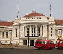 |
 |
| Museum Bank Mandiri | See Bank Mandiri Museum | 1917[142] | J.J. de Bruyn, A.P. Smits and C. van der Linde[142] | 6°08′17″S 106°48′47″E / 6.138170°S 106.813085°E |  |
 |
| Museum Sasmita Loka Ahmad Yani | residence of Ahmad Yani / residence | 1930[143] | 6°12′16″S 106°50′11″E / 6.204564°S 106.836524°E |  |
||
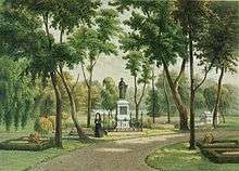
| Museum Taman Prasasti | Europese Kerkhof | 6°10′20″S 106°49′08″E / 6.172196°S 106.818946°E |  |
 | ||
| Museum Wayang | Museum of Old Batavia (1939) / Geo Wehry & Co Warehouse | 1912[2] | 6°08′06″S 106°48′45″E / 6.134882°S 106.812603°E | 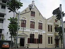 |
 | |
| Nederlandsche Handels Maatschappij te 22 Noordwijk (Demolished in 1984, replaced with Kantor Departemen Keuangan RI bagian KPPN (Kantor Pelayanan Perbendaharaan Negara))[60] | Nederlandsche Handels Maatschappij te 22 Noordwijk / "Factorij"[60] | 1910 | Eduard Cuypers | 6°10′01″S 106°49′39″E / 6.167017°S 106.827407°E | 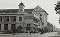 |
 |
| Office building at Jl. Taman Fatahillah no. 2 | Gebouw West Java (WEVA) | 1920 | Eduard Cuypers and Hulswit | Jl. Taman Fatahillah No. 2 Kel. Penjaringan, Kec. Taman Sari Jakarta Barat | ||
| Old City Club | Het Nieuws van den Dag (original) / Asuransi Ikrar Lloyd / Athena Discothèque | 1925–1927[144] | Reyerse de Vries arhitecten- en engenierusbedrijf[144] / Ir. W. Selle | 6°08′07″S 106°48′40″E / 6.135152°S 106.811078°E | |
|
| Oranje Brouwerij (demolished, now Kompleks Rukan Puri DeltaMas Bandengan) | Archipel Brouwerij[145] | Before 1939 | 6°08′16″S 6°47′57″E / 6.137692°S 06.799093°E | 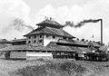 | ||
| Pancoran Tea House[146] | Apotheek Chung Hwa[146] | 1928[146] | unknown; PT Pembangunan Kota Tua Jakarta (JOTRC) and Jakarta Endowment for Arts & Heritage (JEFORAH) (restoration and alteration in 2015) | 6°08′32″S 106°48′53″E / 6.142221°S 106.814604°E | ||
| Pasar Gambir Market Structures/Pavilions (demolished) | Pasar Gambir Market Structures/Pavilions | 6°10′44″S 106°49′33″E / 6.178931°S 106.825833°E |  | |||
| Pelayaran Bahtera Adhiguna | The Ships Agency Ltd Office | 19th century[147] | 6°08′08″S 106°48′44″E / 6.135544°S 106.812098°E |  |
||
| Pertamina headquarter (1957), front section is rented to Bank Mandiri.[148] | Batavia Petroleum Maatschappij (original)[148] / Japanese Military Headquarter[148] / General Staff of the Army (before 1950)[148] | 1937[148] | anonymous | 6°10′22″S 106°49′51″E / 6.172885°S 106.830722°E |  |
 |
| Rathkamp and Co. Pharmacy (demolished after 1948) | Rathkamp and Co. Pharmacy | anonymous | 6°10′08″S 106°49′16″E / 6.168837°S 106.821009°E | 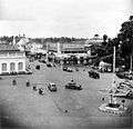 |
 | |
| Rumah Sakit PELNI Petamburan, "PELNI Petamburan Hospital" | KPM Petamboeran Hospital[149] | 1914–1915, 1920 (extension) | Frans Ghijsels | 6°11′35″S 106°48′13″E / 6.193155°S 106.803531°E |  | |
| Rumah Sakit Umum Dr. Cipto Mangunkusumo, "Cipto Mangunkusumo General Hospital" | Medicinal warehouse for the Ministry of Health of the Dutch Colonial Government / Teaching Hospital (1919) / Het Centrale Burgerlijke Hospitaal (CBZ) or "Central Civil Hospital of Batavia" / Ika Dai Gakku Byoin (1942–1945)[150] | 1919–1926[150] | 6°11′50″S 106°50′51″E / 6.197111°S 106.847549°E |  |
 | |
| Samudera Indonesia Commercial Fleet Division (Breakbulk & NVOCC) office building[151] | Maintz & Co Office[151] | 1920s[151] | F.J.L. Ghijsels[151] | 6°07′59″S 106°48′38″E / 6.132948°S 106.810554°E | ||
| Singer Building[152] | Singer and Nitour Travel Agency Building (early 1950s)[153] | 1938[153] | F.W. Brinkman | 6°10′05″S 106°49′15″E / 6.168118°S 106.820704°E |  |
|
| SMK Santa Maria | Koningin Emma School[80] | 20th century[80] | 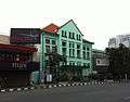 |
|||
| St. Aloysius Broederschool (demolished, on its site stands carpark of Pertamina Headquarter) | St. Aloysius Broederschool[154] | 1908 (construction) | P.A.J. Moojen[155] | 6°10′24″S 106°49′51″E / 6.173346°S 106.830867°E | _richting_Lapangan_Banteng_TMnr_20025716.jpg) |
 |
| Stasiun Jatinegara | Station Meester Cornelis | 1910[156] | S. Snuyff[156] | 6°12′55″S 106°52′13″E / 6.215183°S 106.870276°E |  |
 |
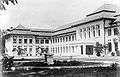
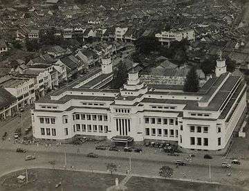
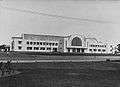
| Stasiun Gambir 2nd form (post-independence) | Station Weltevreden (1884) / Station Batavia Koningsplein (1937)[157] | 1927[157] | anonymous | 6°10′36″S 106°49′50″E / 6.176660°S 106.830617°E |  |
 |
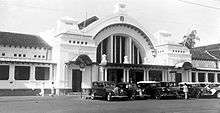
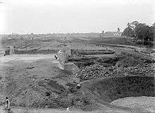
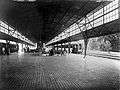
| Stasiun Kota | Station BEOS | 1926 | Frans Ghijsels | 6°08′16″S 106°48′52″E / 6.137672°S 106.814421°E |  |
 |
| Stasiun Manggarai | Station Manggarai | 1918 | van Grendt | 6°12′36″S 106°51′01″E / 6.210055°S 106.850247°E | 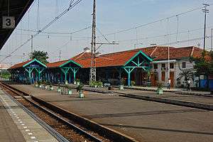 |
 |
| Stasiun Pasar Senen | Station Pasar Senen | 1916, March 19, 1925 (inauguration)[158] | J. Van Gendt, for Staats Spoorwegen (SS)[158] | 6°10′27″S 106°50′40″E / 6.174223°S 106.844469°E |  |
 |
| Stasiun Tanjung Priok | State Railway Company's Railway Station | 1914 | C.W. Koch | 6°06′38″S 106°52′53″E / 6.110642°S 106.881511°E | 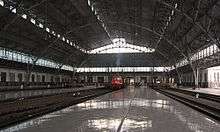 |
 |
| Station Batavia Koninsplein 1st form (renovated into current form in 1927)[157] | Station Weltevreden (1884) | 1884[157] | 6°10′36″S 106°49′50″E / 6.176660°S 106.830617°E | |||
| Station Batavia Zuid (demolished) | Station Batavia Zuid | anonymous | _het_latere_station_Batavia_Zuid_van_de_Staatsspoorwegen_(SS)_in_Batavia_TMnr_10013995.jpg) | |||
| Station Tandjong Priok (demolished in 1917) | Station Tandjong Priok | 1885[159] | anonymous | 6°06′40″S 106°52′51″E / 6.111039°S 106.880963°E | ||
| Taman Kehormatan Belanda Menteng Pulo or "Menteng Pulo Netherlands Field of Honour"[160][161] | Ereveld Menteng Poelo | 1947;[160] Simultaankerk, columbarium in 1950[161] | H. van Oerle from Royal Netherlands Engineers[160] | 6°13′22″S 106°50′23″E / 6.222654°S 106.839678°E |  |
 |
| Topografisch Bureau (abandoned and destroyed)[162] | Topografisch Bureau | 1868, 1907 (older building demolished and replaced)[162] | ||||
| The Hermitage Hotel, Menteng | Telefoongebouw Menteng (original) / Departement van Onderwijs en Eredienst / Office of the Central Indonesian National Committee or KNIP (1945-1946) / National Education Ministry (1950) / Department of Education and Culture (1968-1996) | 1923-1924[163] | anonymous | 6°11′53″S 106°50′17″E / 6.198136°S 106.838039°E | ||
| Telefoonkantoor aan het Koningsplein (demolished) | Telefoonkantoor aan het Koningsplein | circa 1924[164] | anonymous | 6°07′53″S 106°48′38″E / 6.131250°S 106.810594°E |  | |
| Toko Tio Tek Hong | Toko Tio Tek Hong | 1902 | owned by Tio Tek Hong | 6°10′02″S 106°49′54″E / 6.167141°S 106.831749°E |  |
 |
| Toshiba Office | John Peet & Co Office | around 1920[165] | Ir. FJL Ghijsels[165] | 6°08′00″S 106°48′38″E / 6.133426°S 106.810650°E | 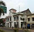 |
 |
| Unie Gebouw (demolished) | Unie Gebouw | 6°09′47″S 106°49′14″E / 6.163179°S 106.820677°E |  |
 | ||
| Vereniging Toeristenverkeer – Official Tourist Bureau (demolished) | Vereniging Toeristenverkeer te Rijswijk – Official Tourist Bureau | 1910[166] | 6°10′04″S 106°49′22″E / 6.167891°S 106.822847°E | |||
| Vliegstationgebouw Tjililitan (demolished) | Vliegstationgebouw Tjililitan | 1928 | H.A. Breuning |  | ||
| Airport Kemayoran (dysfunction) | Luchthaven Kemajoran (older structure demolished and replaced) | 1938 |  |
%2C_p45.jpg) | ||
| Warehouse (abandoned, deteriorating) | Dasaad Musin Concern / Residence of the Director of NV. Pabrik Tenoen Kantjil Mas, Bangil, Djawa Timoer / Gebouw Mercurius[3] | 1920[3] | Vromans[3] | 6°08′02″S 106°48′46″E / 6.133967°S 106.812800°E |  |
 |
| Wilhelmina Park Atjeh Monument (demolished in the 1950s, on its site stand the Istiqlal Mosque, Jakarta) | Wilhelmina Park Atjeh Monument | 1880-1882[167] | Bart van Hove, Pierre Cuypers[168] | 6°10′06″S 106°49′51″E / 6.168333°S 106.830884°E |  |
 |
See also
Notes and references
| Wikimedia Commons has media related to Colonial buildings in Jakarta. |
- Notes
- ↑ The location of the Vierkant point was earlier the location of the English lodge / Shabandar point which exist prior the establishment of Batavia.[5]
- ↑ The house was bought by Van der Parra in 1767.[23]
- ↑ The Old Church of Holland was demolished to make way for the organ that was too large for the church.[32]
- ↑ Earlier it was the location of the Zeeland defence point to the west of Batavia.[5]
- ↑ According to a plaque in front of Toko Merah.
- ↑ so called because it was the tallest building in Grogol during the colonial area.[39]
- ↑ Material for the building was collected from Kasteel Batavia, dismantled in 1809.[46]
- ↑ The material for the construction of the building were taken from the 17th century Spinhuis in Jakarta Old Town.[49]
- ↑ established by A. Chaulan and J.J. Didero.[55]
- ↑ The construction of the building used the former bricks of the wall of Old Batavia.[15]
- ↑ Firma TIEDEMAN & VAN KERCHEM / – NV. Assurantie Maatschappij "De Nederlanden van 1845". FATUM. LABOR. / NEDERLANDSCH-INDISHE, Zee-en Brand Assurantie Maatschappij / TWEEDE NEDERLANDSCH-INDISHE, Zee-en Brand Assurantie Maatschappij / KOLONIALE, Zee-en Brand Assurantie Maatschappij / TWEEDE KOLONIALE, Zee-en Brand Assurantie Maatschappij / Zee-en Brand Assurantie Maatschappij "De Oosterling" / NV. Cult. Mij. Bodjong Datar / NV. Landb.Mij. Dajeuh Manggoeng / NV. Cult.Mij. Gandasoli / NV. The Indo Java, Rubber Planting & Trading Cy. / NV. Cult.Mij. Juliana / NV. Landb.Mij. Kertamanah / NV. Lebak Palantations Cy.Ltd. / NV. Marywattie Tea Cy./ NV. Landb. Mij. Radjamandala / NV. Cult.Mij. Takokak / NV. Cult.Mij. Tandjong Oost / NV. Landb.Mij. Tjiletab / NV. Bombay Java Trading Cy[109]
- References
- ↑ Gunawan Tjahjono, ed. (1998). Architecture. Indonesian Heritage. 6. Singapore: Archipelago Press. p. 108. ISBN 981-3018-30-5.
- 1 2 3 4 5 6 7 8 9 10 11 12 13 14 15 16 Gunawan Tjahjono, ed. (1998). Architecture. Indonesian Heritage. 6. Singapore: Archipelago Press. ISBN 981-3018-30-5.
- 1 2 3 4 5 6 7 8 9 10 11 12 13 14 15 16 17 18 19 20 "Indische Literaire Wandelingen - Jakarta". Indische Literaire Wandelingen. Indische Literaire Wandelingen. Retrieved June 17, 2015.
- 1 2 3 4 5 Teeuwen, Dirk (2011). Batavia’s Wilhelmina Park – Jakarta’s Mosque Istiqlal.
- 1 2 3 4 5 6 7 8 9 10 11 12 13 14 15 16 17 18 19 20 21 22 23 24 25 26 27 28 29 30 31 32 33 34 35 36 37 Kaart van het Kasteel en de Stad Batavia in het Jaar 1667 [Map of the Castle and the City Batavia in year 1667] (Map) (Den Haag ed.). 50 rhijnlandsche roeden (in Dutch). Cartography by J.J. Bollee. G.B. Hooyer and J.W. Yzerman. 1919. date inset.
- 1 2 3 4 5 6 7 Abdurrachman Surjomihardjo (1977). Pemekaran Kota (The Growth of Jakarta). Jakarta: Djambatan.
- 1 2 3 4 Die Rhede von Batavia, 1655 Batavia Map. Homann Heirs Nuremberg Publication
- ↑ Pradaningrum Mijarto (December 1, 2009). "Mengenal Obyek Wisata Pesisir Jakarta Utara". Wisata Kota Toea (in Indonesian). Kompas, Warta Kota. Retrieved July 7, 2011.
- 1 2 https://galz25.wordpress.com/2009/05/28/dari-ziekenhuis-ke-museum-bi/ Dari Ziekenhuis ke Museum BI
- 1 2 3 Hospitals of Netherlands East Indies 1890 – 1940 - A Comprehensive Study
- ↑ A. Algra and H. Algra (1978). Twintig eeuwen historie van de Nederlanden. Deel 4. Franeker: T. Wever. p. 31. Retrieved May 11, 2011.
- 1 2 Jan Sihar Aritonang; Karel Adriaan Steenbrink (2008). A History of Christianity in Indonesia. 35. BRILL. p. 122. ISBN 900417026X. Retrieved July 19, 2013.
ISBN 9789004170261
- ↑ "1001 Warna Teluk Jakarta". National Geographic Traveller Indonesia (in Indonesian). National Geographic Traveller Indonesia. October 26, 2009. Archived from the original on September 11, 2011. Retrieved June 19, 2011.
- 1 2 "Angke, Fort" (in Indonesian). Jakarta City Administration. Retrieved July 6, 2011.
- 1 2 3 "Het beroemde Hotel Des Indes in Batavia heette ooit Hotel Rotterdam, maar dankzij Multatuli". Engelfriet.net. Retrieved May 14, 2014.
- ↑ Jagad Mayanipun Mas Oyé. Masoye.multiply.com. Retrieved July 6, 2011.
- ↑ "Candra Naya". Nile Guide. Nile Project. Retrieved March 27, 2011.
- 1 2 3 "Candranaya, Gedung". Ensiklopedi Jakarta (in Indonesian). Dinas Komunikasi, Informatika dan Kehumasan Pemprov DKI Jakarta. 2010. Retrieved July 8, 2011.
- ↑
- ↑ Windoro Adi (2010). Batavia 1740: menyisir jejak Betawi (in Indonesian). PT Gramedia Pustaka Utama. p. 226. ISBN 979-22-5451-X. Retrieved June 2, 2011.
- 1 2 3 Asia Finest Discussion Forum - Pic's of VOC forts in Ambon. Asiafinest.com. Retrieved July 6, 2011.
- 1 2 "Weltevreden" (in Indonesian). Jakarta City Administration. Retrieved July 6, 2011.
- ↑ afbeelding: Gezicht op landhuis Weltevreden te Batavia. Atlasofmutualheritage.nl. Retrieved July 6, 2011.
- ↑ . Mengintip Sisa Rumah Tuan Tanah di Pasar Rebo. Detik News. Retrieved February 12, 2015.
- ↑ . Landgoed Groeneveld. Familie Wiki. Retrieved February 12, 2015.
- 1 2 . A beautiful Dutch villa in ruins. Jakarta Post. Retrieved February 12, 2015.
- 1 2 3 Jagad Mayanipun Mas Oyé. Masoye.multiply.com. Retrieved July 6, 2011.
- 1 2 3 4 5 Jembatan Gantung Kota Intan, jembatan indah yang terlupakan, September 2013
- ↑ Djawa Tempo Doeloe – by Priambodo Prayitno. Djawatempodoeloe.multiply.com. Retrieved July 6, 2011.
- 1 2 Tjandrasasmita, Uka (2009). Arkeologi Islam Nusantara (in Indonesian). Kepustakaan Populer Gramedia. p. 156. ISBN 979-9102-12-X. Retrieved September 4, 2011.
ISBN 9789799102126
- ↑ Het Indische bouwen: architectuur en stedebouw in Indonesie : Dutch and Indisch architecture 1800-1950. Helmond: Gemeentemuseum Helmond. 1990. pp. 7–11. Retrieved March 30, 2015.
- 1 2 Antique photos from colonial times – Asia Finest Discussion Forum. Asiafinest.com. Retrieved July 7, 2011.
- 1 2 "Jakarta's Oldest Chinese Temple: the Jin De Yuan or Vihara Dharma Bhakti". Indonesia Travel. Ministry of Tourism and Creative Economy. 2013. Retrieved November 26, 2013.
- ↑ File: Design for a water fort on Batavia. Atlasofmutualheritage.nl. Retrieved July 6, 2011.
- ↑ "Water Kasteel" (in Indonesian). Jakarta City Administration. Retrieved July 6, 2011.
- 1 2 Gedung BP7 Archived August 20, 2010, at the Wayback Machine.
- 1 2 "History of All Saints Church, Jakarta". All Saints Church Jakarta. All Saints Church Jakarta. Retrieved August 12, 2013.
- ↑ "De Armeniërs, een volk waar ik deels van afstam.". imexbo.nl. imexbo.nl. Retrieved June 21, 2015.
- 1 2 3 "Rumah Tinggi Palmerah" (in Indonesian). Dinas Komunikasi, Informatika dan Kehumasan Pemprov DKI Jakarta. Archived from the original on July 8, 2011. Retrieved August 13, 2011.
- ↑ "Rumah Tinggi Palmerah". Ensiklopedi Jakarta (in Indonesian). Jakarta City Administration. Retrieved July 7, 2011.
- ↑ "Balai Kota, Gedung" (in Indonesian). Jakarta City Administration. Retrieved July 6, 2011.
- 1 2 Djawa Tempo Doeloe – by Priambodo Prayitno. Djawatempodoeloe.multiply.com. Retrieved July 6, 2011.
- 1 2 3 4 Windoro Adi (2010). Batavia, 1740: menyisir jejak Betawi [Batavia, 1740: sweeping up the footsteps of Betawi] (in Indonesian). Jakarta: PT Gramedia Pustaka Utama. p. 70. ISBN 9789792254518.
- ↑ "Marine, Hotel". Ensiklopedi Jakarta. Dinas Komunikasi, Informatika dan Kehumasan Pemprov DKI Jakarta. Retrieved July 5, 2011.
- 1 2 3 4 Dewan Kerajinan Nasional Archived May 16, 2011, at the Wayback Machine.
- 1 2 3 4 Gedung Departemen Keuangan Archived August 20, 2010, at the Wayback Machine.
- ↑ "Perpustakaan Nasional, Gedung" (in Indonesian). Jakarta City Administration. Retrieved July 6, 2011.
- 1 2 3 4 5 6 "Sekolah Raja Di Tengah Kota" [Royal School in the Middle of the City]. Berita Indonesia (in Indonesian). Jakarta: Berita Indonesia. Retrieved November 27, 2013.
- 1 2 "Schouwburg" (in Indonesian). Jakarta City Administration. Retrieved July 6, 2011.
- 1 2 Republika Online – Gedung Lahirnya Pancasila, UUD 1945, dan Piagam Jakarta. Republika.co.id:8080 (February 13, 2010). Retrieved July 6, 2011.
- 1 2 3 4 Gedung Pancasila
- 1 2 Djawa Tempo Doeloe – by Priambodo Prayitno. Djawatempodoeloe.multiply.com. Retrieved July 6, 2011.
- 1 2 3 4 5 6 "Der Nederlanden, Hotel". Ensiklopedi Jakarta. Dinas Komunikasi, Informatika dan Kehumasan Pemprov DKI Jakarta. Retrieved May 12, 2011.
- 1 2 3 4 Rumah Raffles, Hotel der Nederlanden Hingga Bina Graha – Arkeologi Indonesia. Arkeologi.web.id (December 26, 2009). Retrieved July 6, 2011.
- 1 2 3 4 Djawa Tempo Doeloe – by Priambodo Prayitno. Djawatempodoeloe.multiply.com. Retrieved July 6, 2011.
- 1 2 Djawa Tempo Doeloe – by Priambodo Prayitno. Djawatempodoeloe.multiply.com. Retrieved July 6, 2011.
- ↑ Djawa Tempo Doeloe – by Priambodo Prayitno – Kawasan Rijswijk – Noordwijk, Batavia 1900–2008. Djawatempodoeloe.multiply.com (January 22, 2008). Retrieved July 6, 2011.
- ↑ Djawa Tempo Doeloe – by Priambodo Prayitno. Djawatempodoeloe.multiply.com. Retrieved July 6, 2011.
- ↑ Djawa Tempo Doeloe – by Priambodo Prayitno. Djawatempodoeloe.multiply.com. Retrieved July 6, 2011.
- 1 2 3 4 Priambodo Prayitno. "Djawa Tempo Doeloe". Retrieved April 2, 2011.
- 1 2 "Coen, Monumen". Ensiklopedi Jakarta (in Indonesian). Dinas Komunikasi, Informatika dan Kehumasan Pemprov DKI Jakarta. 2010. Retrieved July 11, 2011.
- 1 2 3 Mardani (June 23, 2012). "Mengungkap bekas 'gedung setan' di Jakarta". www.merdeka.com. KLN Kapanlagi Network. Retrieved February 23, 2015.
- 1 2 Alwi Shahab (September 29, 2007). "Jaringan Zionis di Rumah Setan". Djakarta Tempoe Doeloe (in Indonesian). Republika. Retrieved June 5, 2015.
- 1 2 Stevens, Th. Vrijmetselarij en samenleving in Nederlands Indie en Indonesie 1764-1962 (Publisher: Verloren, Hilversum) ISBN 90-6550-378-1
- ↑ Djawa Tempo Doeloe – by Priambodo Prayitno. Djawatempodoeloe.multiply.com. Retrieved July 6, 2011.
- 1 2 Djawa Tempo Doeloe – by Priambodo Prayitno. Djawatempodoeloe.multiply.com. Retrieved July 6, 2011.
- ↑ "Hoogerechshaf, Gedung" (in Indonesian). Jakarta City Administration. Retrieved July 6, 2011.
- ↑ Wisata Kota Tua – Mengenal.obyek.wisata.pesisir.jakarta.utara. .kompas.com (December 16, 2008). Retrieved July 6, 2011.
- 1 2 Masjid Jami Kebon Jeruk
- ↑ "Concordia, Gedung" (in Indonesian). Jakarta City Administration. Retrieved July 6, 2011.
- ↑ "Nasional, Museum". Ensiklopedi Jakarta (in Indonesian). Jakarta City Administration. Retrieved August 24, 2011.
- ↑ "Sasmita Loka A. Yani, Museum". Ensiklopedi Jakarta (in Indonesian). Dinas Komunikasi, Informatika dan Kehumasan Pemprov DKI Jakarta. Retrieved August 24, 2011.
- ↑ Jagad Mayanipun Mas Oyé. Masoye.multiply.com. Retrieved July 7, 2011. Archived August 20, 2011, at the Wayback Machine.
- ↑ Pradaningrum Mijarto (April 21, 2009). "Yang Tersisa dari Toko Buku Pertama di Batavia" (in Indonesian). Kompas. Retrieved August 31, 2013.
- ↑ Djawa Tempo Doeloe – by Priambodo Prayitno. Djawatempodoeloe.multiply.com. Retrieved July 7, 2011.
- ↑ Apotik Kimia Farma Archived February 26, 2011, at the Wayback Machine.
- ↑ Latar Belakang Sejarah PNRI
- ↑ Djawa Tempo Doeloe – by Priambodo Prayitno. Djawatempodoeloe.multiply.com. Retrieved July 6, 2011.
- ↑ "Rumah Sakit Cikini (Cikini Hospital)". Nile Guide. Nile Project. Retrieved March 27, 2011.
- 1 2 3 4 Djawa Tempo Doeloe – by Priambodo Prayitno. Djawatempodoeloe.multiply.com. Retrieved July 6, 2011.
- ↑ Djawa Tempo Doeloe – by Priambodo Prayitno. Djawatempodoeloe.multiply.com. Retrieved July 6, 2011.
- ↑ Villa Nova
- ↑ "Adek in Batavia". Indische Kamparchieven. Nederlands Instituut voor Oorlogsdocumentatie (NIOD). Retrieved June 20, 2015.
- 1 2 Élan Kooy, Michelle (2008). RELATIONS OF POWER, NETWORKS OF WATER: GOVERNING URBAN WATERS, SPACES, AND POPULATIONS IN (POST)COLONIAL JAKARTA. Vancouver: The University of British Columbia. p. 46.
- ↑ KANTOORGEBOUWEN WEST JAVA HANDEL MAATSCHAPPIJ (BATAVIA)
- ↑ Y-6 (March 19, 2011). "12 Gedung Tua di Kawasan Kota Tua Rawan Ambruk" (in Indonesian). Suara Pembaruan. Retrieved August 28, 2011.
- 1 2 3 "Kantoorgebouw De Nederlanden van 1845". Coloniale architecture and town planning. Delft University of Technology. Retrieved September 16, 2015.
- 1 2 Bambang Irawan (May 31, 2014). "Berlage on Aperdi/Algemeene Building in Surabaya". Ayorek.org. Translated by Emily Wallace. Ayorek.org. Retrieved September 16, 2015.
- ↑ "BAB III" (PDF). Petra Christian University Library. Digilib.petra.ac.id. Retrieved September 24, 2013.
- 1 2 Djawa Tempo Doeloe – by Priambodo Prayitno. Djawatempodoeloe.multiply.com. Retrieved July 6, 2011.
- ↑ http://www.jakarta.go.id/web/news/2010/01/Asuransi-Wahana-Tata
- ↑ Djawa Tempo Doeloe – by Priambodo Prayitno. Djawatempodoeloe.multiply.com. Retrieved July 6, 2011.
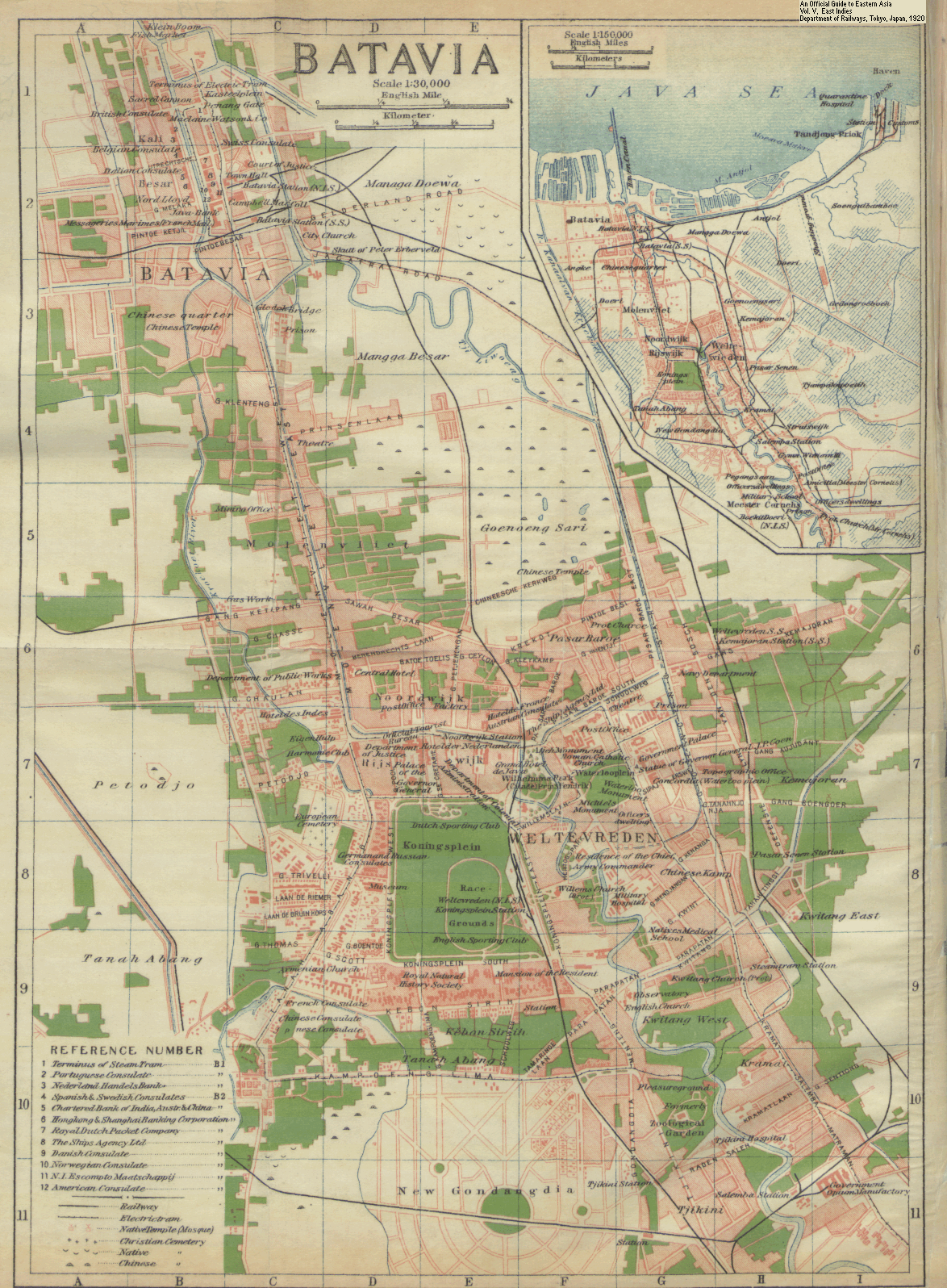
- 1 2 An Official Guide to Eastern Asia - Batavia (Map). 30000. Cartography by Department of Railways, Tokyo, Japan. G.B. Hooyer and J.W. Yzerman. 1920. Retrieved September 24, 2013.
- 1 2 "Kota Betawi". Kotabetawi.blogspot.com. September 30, 2009. Retrieved May 14, 2014.
- ↑ "Yacht Club". Ensiklopedi Jakarta. Dinas Komunikasi, Informatika dan Kehumasan Pemprov DKI Jakarta. 2013. Retrieved November 27, 2013.
- ↑ Merrillees 2015, p. 92.
- 1 2 3 Jagad Mayanipun Mas Oyé. Masoye.multiply.com. Retrieved July 6, 2011.
- ↑ http://kekunaan.blogspot.com/2012/07/gedung-ex-nederlandsch-indisch.html Gedung Ex Nederlandsch Indisch
- ↑ http://bataviadigital.perpusnas.go.id/foto/?box=detail&id_record=240&npage=11&search_key=&search_val=&status_key=&dpage=1 Lapangan Stasiun Kota
- 1 2 Jagad Mayanipun Mas Oyé. Masoye.multiply.com. Retrieved July 6, 2011.
- 1 2 3 "Google Earth – 3d Model by HMC". Sketchup.google.com. Retrieved May 14, 2014.
- 1 2 3 4 5 6 7 Djawa Tempo Doeloe – by Priambodo Prayitno. Djawatempodoeloe.multiply.com. Retrieved July 6, 2011.
- ↑ Djawa Tempo Doeloe – by Priambodo Prayitno – Kawasan Rijswijk – Noordwijk, Batavia 1900–2008. Djawatempodoeloe.multiply.com (January 22, 2008). Retrieved July 6, 2011.
- ↑ Jakarta.go.id - Banteng Building
- 1 2 My Odyssey. Trails of Ghijsels in Batavia: The Order of Freemasons Lodge. April 6, 2006.
- 1 2 3 4 5 6 Het Indische bouwen: architectuur en stedebouw in Indonesie : Dutch and Indisch architecture 1800-1950. Helmond: Gemeentemuseum Helmond. 1990. pp. 28–33. Retrieved March 30, 2015.
- ↑ Trails of Ghijsels in Batavia
- ↑ Bengkel Praktek Kerja Pendidikan Teknik Archived August 20, 2010, at the Wayback Machine.
- ↑ Jagad Mayanipun Mas Oyé. Masoye.multiply.com. Retrieved July 6, 2011.
- 1 2 3 "Menteng Bioscoop (Jakarta)" (in Indonesian). NAi. Retrieved July 6, 2011.
- ↑ Merrillees 2015, p. 87.
- 1 2 Akihary 1990, p. 122.
- ↑ "Gebouw Raad van Indië". Coloniale architecture and town planning. Delft University of Technology. Retrieved August 31, 2015.
- ↑ Bangunan Gedung Jl Kunir no 2 Archived October 12, 2010, at the Wayback Machine.
- ↑ My Odyssey. Trails of Ghijsels in Batavia (4): "Unendorsed" Geo Wehry & Co. Office Building. 2006/1/12
- 1 2 3 Gedung PT Tjipta Niaga
- 1 2 Jagad Mayanipun Mas Oyé. Masoye.multiply.com. Retrieved July 7, 2011.
- 1 2 Gedung Departemen Keuangan Kantor Badan Urusan Piutang Negara Archived May 26, 2010, at the Wayback Machine.
- 1 2 3 4 Departemen Pertahanan dan Keamanan Hankam
- ↑ Djawa Tempo Doeloe – by Priambodo Prayitno. Djawatempodoeloe.multiply.com. Retrieved July 7, 2011.
- ↑ "Bekas Kantor Asuransi Kini Melompong". Warta Kota (in Indonesian). March 24, 2009. Retrieved August 26, 2011.
- 1 2 3 4 "STOVIA, Gedung". Ensiklopedi Jakarta (in Indonesian). Dinas Komunikasi, Informatika dan Kehumasan Pemprov DKI Jakarta. 2011. Retrieved August 10, 2011.
- 1 2 3 4 Akihary 1990, p. 112.
- ↑ Gedung Perusahaan Listrik Negara
- ↑ http://media-kitlv.nl/image/1fb937cf-5693-4267-8089-6de8678c8af8
- 1 2 Rinno Widianto (2009). Gereja-Koinonia (PDF) (in Indonesian). Depok: FIB UI. p. 19. Retrieved September 24, 2013.
- ↑ Haantjes Kerk
- 1 2 "Nassaukerk" (in Indonesian). Dinas Komunikasi, Informatika dan Kehumasan Pemprov DKI Jakarta. 2011. Retrieved August 7, 2011.
- ↑ Yustina M Widhartantri (July 3, 2009). "Gereja St Yoseph Matraman, Saksi Sejarah Kota Militer". Wisata Kota Tua (in Indonesian). Kompas. Retrieved June 10, 2011.
- 1 2 My Odyssey. Trails of Ghijsels in Batavia: Roman Catholic Church of H. Jozef. 2006/4/03
- 1 2 "Theresia, Gereja". Ensiklopedi Jakarta. Dinas Komunikasi, Informatika dan Kehumasan Pemprov DKI Jakarta. 2011. Retrieved August 8, 2011.
- ↑ "Sejarah GKI Pinangsia". GKI Pinangsia (in Indonesian). GKI Pinangsia. 2015. Retrieved June 20, 2015.
- 1 2 "Pasar Glodok". Colonial architecture & townplanning. TU Delft Library. 2015. Retrieved August 31, 2015.
- ↑ Jagad Mayanipun Mas Oyé. Masoye.multiply.com. Retrieved July 6, 2011.
- ↑ Jagad Mayanipun Mas Oyé. Masoye.multiply.com. Retrieved July 7, 2011.
- 1 2 Direktorat Jenderal Perhubungan Laut Archived June 9, 2010, at the Wayback Machine.
- ↑ Nurul Ulfah (December 11, 2009). "Melawan Virus Bersama Eijkman" (in Indonesian). DetikHealth. Retrieved April 2, 2011.
- 1 2 Menjaga Autentisitas Eijkman. Bataviase.co.id (September 5, 2010). Retrieved July 7, 2011.
- ↑ "Michiels Monumen". Ensiklopedi Jakarta (in Indonesian). Dinas Komunikasi, Informatika dan Kehumasan Pemprov DKI Jakarta. Retrieved July 6, 2011.
- ↑ "Van Heutszmonument Gambir (Indonesië)" (in Dutch). NAi. Retrieved August 28, 2011.
- 1 2 3 "Gedung Joang '45". Ensiklopedi Jakarta (in Indonesian). Dinas Komunikasi, Informatika dan Kehumasan Pemprov DKI Jakarta. Retrieved July 6, 2011.
- 1 2 P. Nas; Martien de Vletter (2009). Masa lalu dalam masa kini: arsitektur di Indonesia. PT Gramedia Pustaka Utama. p. 142. ISBN 979-22-4382-8. Retrieved September 2, 2011.
ISBN 9789792243826
- ↑ "Sumpah Pemuda, Museum". Ensiklopedi Jakarta (in Indonesian). Dinas Komunikasi, Informatika dan Kehumasan Pemprov DKI Jakarta. Retrieved August 24, 2011.
- 1 2 Akihary 1990, p. 134.
- ↑ Vletter, M.E. de; Voskuil, R.P.G.A.; Diessen, J.R. van (1999). Batavia/Djakarta/Jakarta - Beeld van een Stad. Purmerend: Asia Maior. p. 131. ISBN 9074861091.
- 1 2 3 Twi Wahyuni (December 17, 2015). "Aphoteek Chung Hwa: Rela Terkikis Demi Jakarta". CNN Indonesia (in Indonesian). CNN. Archived from the original on September 11, 2016. Retrieved September 11, 2016.
- ↑ Kantor PT Pelayaran Bahtera Adhiguna Archived September 16, 2009, at the Wayback Machine.
- 1 2 3 4 5 "Pertamina". Ensiklopedi Jakarta. Dinas Komunikasi, Informatika dan Kehumasan Pemprov DKI Jakarta. 2010. Retrieved July 7, 2011.
- ↑ "Sejarah Rumah Sakit PELNI" (in Indonesian). Rumah Sakit Pelni. 2009. Retrieved August 6, 2011.
- 1 2 "Centraal Burgerlijke Ziekenhuis (CBZ)". Ensiklopedi Jakarta (in Indonesian). Dinas Komunikasi, Informatika dan Kehumasan Pemprov DKI Jakarta. 2010. Retrieved July 8, 2011.
- 1 2 3 4 Jagad Mayanipun Mas Oyé. Masoye.multiply.com. Retrieved July 7, 2011.
- ↑ Djawa Tempo Doeloe – by Priambodo Prayitno. Djawatempodoeloe.multiply.com. Retrieved July 7, 2011.
- 1 2 Merrillees 2015, p. 49.
- ↑ Twee vrouwen zitten op het Koningsplein in voormalige Batavia (nu Jakarta) goederen te verkopen, Indonesië (1947) – the Memory of the Netherlands (het Geheugen van Nederland). Geheugenvannederland.nl. Retrieved July 6, 2011.
- ↑ "Broederschool". Coloniale architecture and town planning. Delft University of Technology. Retrieved August 16, 2015.
- 1 2 "Meester Cornelis, Stasiun". Ensiklopedi Jakarta (in Indonesian). Dinas Komunikasi, Informatika dan Kehumasan Pemprov DKI Jakarta. 2010. Retrieved July 10, 2011.
- 1 2 3 4 "Weltevreden, Stasiun". Ensiklopedi Jakarta (in Indonesian). Dinas Komunikasi, Informatika dan Kehumasan Pemprov DKI Jakarta. 2010. Retrieved July 10, 2011.
- 1 2 "Stasiun Pasar Senen" (in Indonesian). PT. KERETA API INDONESIA. June 25, 2010. Retrieved September 16, 2011.
- ↑ "Tanjung Priok, Stasiun". Ensiklopedi Jakarta (in Indonesian). Dinas Komunikasi, Informatika dan Kehumasan Pemprov DKI Jakarta. 2011. Retrieved August 7, 2011.
- 1 2 3 "Menteng Pulo, Kuburan". Ensiklopedi Jakarta (in Indonesian). Dinas Komunikasi, Informatika dan Kehumasan Pemprov DKI Jakarta. 2011. Retrieved July 24, 2011.
- 1 2 Mahandisyonata (May 17, 2006). "OCCASIONAL VISIT TO EREVELD MENTENG PULO". Multiply. Retrieved July 24, 2011.
- 1 2 Djawa Tempo Doeloe – by Priambodo Prayitno. Djawatempodoeloe.multiply.com. Retrieved July 7, 2011.
- ↑ "Telefoongebouw Menteng". Ensiklopedi Jakarta (in Indonesian). Dinas Komunikasi, Informatika dan Kehumasan Pemprov DKI Jakarta. 2010. Retrieved August 8, 2011.
- ↑ "Telefoonkantoor Batavia". Coloniale architecture and town planning. Delft University of Technology. Retrieved August 16, 2015.
- 1 2 Jagad Mayanipun Mas Oyé. Masoye.multiply.com. Retrieved July 7, 2011.
- ↑ Djawa Tempo Doeloe – by Priambodo Prayitno. Djawatempodoeloe.multiply.com. Retrieved July 7, 2011.
- ↑ "Atjeh-monument Batavia (Jakarta, Indonesië)" (in Dutch). NAi. Retrieved August 28, 2011.
- ↑ Djawa Tempo Doeloe – by Priambodo Prayitno. Djawatempodoeloe.multiply.com. Retrieved July 7, 2011.
- Cited works
- Akihary, Huib (1990). Architectuur & Stedebouw in Indonesië 1870/1970. Zutphen: De Walburg Pers. ISBN 9072691024.
- Merrillees, Scott (2015). Jakarta: Portraits of a Capital 1950-1980. Jakarta: Equinox Publishing. ISBN 9786028397308.