List of bridges in Calgary

The City of Calgary has a number of bridges, spanning the two main rivers that cross the city, Bow River and Elbow River, as well as some other geographical and physical features.
The first building in Calgary was erected in 1872 by Alexis Cardinal, at the request of Fr Constantine Scollen, an Oblate missionary priest, at the confluence of the two rivers.
Crossings
Bow River (west of downtown)
The Bow River enters the city from west, winds around downtown, then runs south. From west to south, the following structures cross the river.
| Bridge | Carries | Length | Built | Coordinates | Image | Remarks |
|---|---|---|---|---|---|---|
| Bearspaw Dam | Utility | 1954 | 51°06′04″N 114°16′57″W / 51.10124°N 114.28251°W | Dam on Calgary's west limits, east of Bearspaw; built in 1954,[1] owned and maintained by TransAlta | ||
| Stoney Trail Bridge | Stoney Trail | 476 m | 51°05′53″N 114°13′56″W / 51.09798°N 114.23219°W | |
Between Trans Canada Highway and Tuscany; lower deck is pedestrian, connecting the south and north Bow River pathways | |
| 85 St SW Bridge | 85 Street SW | 51°05′53″N 114°12′38″W / 51.09794°N 114.21052°W |  |
Between Bowness and Scenic Acres | ||
| Bowness Pedestrian Bridge | Pathway | 51°05′52″N 114°12′05″W / 51.09785°N 114.20138°W | |
Connects Bow River pathways between Bowmont Park Natural Area and Bowness | ||
| Bowness Railway Bridge | Canadian Pacific Railway | 51°05′53″N 114°12′00″W / 51.09797°N 114.20002°W | |
|||
| John Hextall Bridge | Pedestrian/Cycle | 1911 | 51°04′43″N 114°10′20″W / 51.07869°N 114.17229°W | 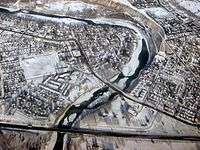 |
Between Bowness and Montgomery; parallels Shouldice Bridge and is used for pedestrian and bicycle traffic only; originally carried a streetcar. | |
| Shouldice Bridge | Bowness Road NW | 51°04′43″N 114°10′20″W / 51.07863°N 114.17236°W | |
Between Bowness, Shouldice Park and Montgomery | ||
| TCH Bridge | Trans-Canada Highway | 51°04′38″N 114°10′39″W / 51.07722°N 114.17745°W | |
Between Sarcee Trail and Montgomery | ||
| Harry Boothman Bridge | Pedestrian | 51°03′53″N 114°09′16″W / 51.06464°N 114.15453°W | |
Pedestrian alley in Edworthy Park, between the Bow River pathways; named for Harry Boothman. superintendent and director of Calgary Parks from 1958 to 1976 | ||
| Crowchild Trail Bridge | Crowchild Trail | 51°02′49″N 114°06′54″W / 51.04686°N 114.11494°W | Between Shaganappi and Kensington, lower pedestrian deck connects pathways on each side of the river | |||
| 14 St SW Bridge | 14 St SW | 51°02′53″N 114°05′41″W / 51.04801°N 114.09471°W | |
Between Kensington and Sunalta | ||
Bow River (downtown)


Bow River (south of downtown)
| Bridge | Carries | Length | Built | Coordinates | Image | Remarks |
|---|---|---|---|---|---|---|
| Cushing Bridge | Blackfoot Trail SE / International Avenue | 51°02′14″N 114°00′46″W / 51.03736°N 114.01280°W | Connects Inglewood with Forest Lawn; named after William Henry Cushing, Calgary mayor from 1900 to 1901[2] | |||
| CPR Bonnybrook Bridge | Canadian Pacific Railway | 51°00′51″N 114°00′44″W / 51.014254°N 114.012294°W | Pony truss railroad bridge, connects three main tracks (P-1 mainline, P-2 lead and Old Ogden lead) with CPR Alyth Yard. The bridge is partially collapsed after flooding of Bow River in June 2013.[5] Steel bridge added in 1971.
and Old Ogden lead, | |||
| CNR Bow River Bridge | Canadian National Railway | 51°00′52″N 114°00′41″W / 51.014403°N 114.011521°W | Through truss bridge has a single track. | |||
| Bonnybrook Bridge | Ogden Road SE | 51°00′46″N 114°00′46″W / 51.01290°N 114.01284°W | Vehicular bridge carries Ogden Road and connects Alyth with Foothills Industrial Park | |||
| Calf Robe Bridge | Deerfoot Trail | 51°00′31″N 114°01′07″W / 51.00856°N 114.01869°W | Connects Deerfoot trail from Glenmore Trail to Peigan Road; named after Ben Calf Robe, a Siksika chief | |||
| Canadian National Bridge | CN Railway | 51°00′16″N 114°01′19″W / 51.00437°N 114.02195°W | Connects Canadian Pacific Railway to Canadian National Railway | |||
| Graves Bridge | Glenmore Trail | 50°59′12″N 114°01′29″W / 50.98658°N 114.02466°W | Connects Alyth to Riverbend and Ogden, leads to Highway 8 east; twinned in 2009[6] | |||
| Sue Higgins Bridge | Pedestrian | 50°58′10″N 114°01′33″W / 50.96957°N 114.02575°W | Connects Southland Drive and Acadia to Riverbend | |||
| Lafarge Bridge | Road | 50°57′23″N 114°01′23″W / 50.95651°N 114.02295°W | Connects Lafarge cement plant to Douglasglen | |||
| Ivor Strong Bridge | Deerfoot Trail | 50°57′09″N 114°01′14″W / 50.95259°N 114.02058°W | Connects Maple Ridge to Douglasdale at the Anderson Road alignment; named after John Ivor Strong, Chief Commissioner for the City of Calgary from 1965 to 1971 | |||
| Douglasdale Park Pedestrian Bridge | Pedestrian | 50°56′27″N 114°00′40″W / 50.94090°N 114.01109°W | Connects Douglasdale Park to Queensland | |||
| McKenzie Pedestrian Bridge | Pedestrian | 50°54′42″N 113°59′54″W / 50.91178°N 113.99827°W | Connects Deer Ridge with McKenzie Lake | |||
| Marquis de Lorne Bridge | Stoney Trail | 2009[7] | 50°53′40″N 114°00′34″W / 50.89435°N 114.00937°W | |
Connects Marquis de Lorne Trail m from Sundance and Chaparral across Fish Creek Provincial Park to McKenzie Lake and Cranston | |
| Dunbow Road Bridge | Highway 2 | 50°51′15″N 113°58′15″W / 50.85420°N 113.97095°W | Connects Deerfoot Trail to Macleod Trail south of Calgary, between Auburn Bay and Heritage Pointe | |||
Elbow River
The Elbow River enters the city in the south-west, then turns north and merges into the Bow River immediately east of downtown. From west to north, the following structures cross the river.
| Bridge | Carries | Length | Built | Coordinates | Image | Remarks |
|---|---|---|---|---|---|---|
| Twin Bridges | Highway 8 | 51°01′01″N 114°14′25″W / 51.01693°N 114.24017°W | Highway 8 named Glenmore Trail east of this point | |||
| Weaselhead Road Bridge | Weasel Head Road | 50°59′42″N 114°09′55″W / 50.99497°N 114.16535°W | Private bridge for road traffic, inside the limits of the Tsuu T'ina Nation reserve | |||
| Weaselhead Pedestrian Bridge | Pedestrian | 50°59′29″N 114°8′48″W / 50.99139°N 114.14667°W | Bridge within the Weaslehead Natural Area | |||
| Glenmore Trail Causeway | Glenmore Trail | 50°59′43″N 114°05′57″W / 50.99530°N 114.09928°W | |
Crosses the Glenmore Reservoir | ||
| Glenmore Dam | Pedestrian, maintenance road | 1933 | 51°00′00″N 114°05′50″W / 50.99990°N 114.09715°W | Dam, created Glenmore Reservoir, allows pedestrian access and maintenance vehicles (no public vehicle access) along Glenmore Bridge Rd. | ||
| Sandy Beach Bridge | Pedestrian | 51°00′43″N 114°05′31″W / 51.01199°N 114.09182°W | Connects River Park (in Altadore) and Riverdale Park (in Britannia) | |||
| Elbow Park Britannia Pedestrian Bridge | Pedestrian | 51°01′08″N 114°04′59″W / 51.01887°N 114.08317°W | Connects Elbow River bike and pathway; between Elbow Park and Britannia | |||
| Elbow Drive Bridge | Elbow Drive | 51°01′04″N 114°04′40″W / 51.01786°N 114.07788°W | Connects the neighbourhoods of Elbow Park and Britannia | |||
| Elbow Park Rideau Park Pedestrian Bridge | Pedestrian | 51°01′30″N 114°04′40″W / 51.02495°N 114.07779°W | Connects Elbow River bike and pathway; between Elbow Park and Rideau Park | |||
| 4 St SW Bridge | 4 Street SW | 51°01′46″N 114°04′17″W / 51.02934°N 114.07152°W |  |
Connects the neighbourhoods of Mission and Roxboro | ||
| Scollen Bridge | 25 Avenue SW | 51°01′49″N 114°03′48″W / 51.03041°N 114.06343°W | |
Connects the neighbourhoods of Mission and Erlton | ||
| 21 Ave SW Talisman Pedestrian Bridge | Pedestrian | 51°02′03″N 114°04′03″W / 51.03421°N 114.06751°W | Between 21 Ave SW and the Talisman Centre grounds | |||
| 19 Ave SW Talisman Pedestrian Bridge | Pedestrian | 51°02′09″N 114°03′55″W / 51.03588°N 114.06538°W |  |
Between 19 Ave SW (behind St. Mary's Cathedral and the Talisman Centre grounds | ||
| Pattison Bridge | Macleod Trail South | 51°02′10″N 114°03′41″W / 51.03600°N 114.06126°W | |
Between Mission and Talisman Centre, named for John George Pattison, Victoria Cross recipient of the 50th Battalion, CEF.[8] | ||
| Victoria Bridge | Macleod Trail North | 51°02′04″N 114°03′33″W / 51.03448°N 114.05911°W | |
Between Mission and Talisman Centre | ||
| Macleod Train Bridge | C-Train | 51°2′2″N 114°3′32″W / 51.03389°N 114.05889°W |  |
Between Mission and Talisman Centre | ||
| Stampede Trail Bridge | Stampede Trail SE | 51°01′58″N 114°03′24″W / 51.03265°N 114.05675°W |  |
Provides entry into the Calgary Stampede grounds and access to the Stampede Grandstand | ||
| Stampede Ground Bridge | maintenance road | 51°1′52″N 114°3′2″W / 51.03111°N 114.05056°W |  |
Provides access Calgary Stampede ground buildings | ||
| Stampede Ground Bridge | maintenance road | 51°1′53″N 114°3′1″W / 51.03139°N 114.05028°W |  |
Provides access Calgary Stampede ground buildings | ||
| Saddledome Trail Bridge | Pedestrian | 51°2′13″N 114°2′59″W / 51.03694°N 114.04972°W |  |
Provides entry into the Calgary Stampede grounds and access to the Scotiabank Saddledome | ||
| Agriculture Trail Bridge | Agriculture Trail SE | 51°02′19″N 114°02′55″W / 51.03858°N 114.04873°W |  |
Service road from Calgary Stampede grounds | ||
| Macdonald Avenue Bridge | Macdonald Avenue SE | 51°02′29″N 114°02′41″W / 51.04132°N 114.04474°W | |
Connects the neighbourhoods of Victoria Park and Ramsay | ||
| Canadian Pacific Rail Bridge (Inglewood) | Canadian Pacific Railway | 51°02′35″N 114°02′34″W / 51.04318°N 114.04287°W |  |
Connects the Canadian Pacific Railway downtown yard with the CPR Alyth Yard | ||
| Inglewood Bridge | 9 Avenue SE | 51°02′37″N 114°02′34″W / 51.04366°N 114.04274°W |  |
Connects Downtown East Village to Inglewood | ||
Fish Creek
Fish Creek flows from west to east in the south part of the city, through the Fish Creek Provincial Park. It merges into the Bow River in the South-East quadrant of the city.


See also
References
- ↑ TransAlta Utilities. "Bearspaw". Retrieved 2009-09-19.
- 1 2 "Hon. William Henry Cushing". Retrieved 2009-09-07.
- ↑ Glenbow Museum. "Langevin bridges". Retrieved 2009-12-24.
- ↑ CBC (2010-03-22). "Calgary-Paris partners to build St. Patrick's bridge". CBC News. Retrieved 2010-04-08.
- ↑ http://www.calgarysun.com/2013/06/27/bonnybrook-rail-bridge-in-southeast-calgary-on-verge-of-collapse
- ↑ City of Calgary. "Graves Bridge Twinning". Retrieved 2009-09-07.
- ↑ City of Calgary (2008-07-17). "Marquis of Lorne Trail S.E. / Bow River Bridge Project". Retrieved 2009-09-07.
- ↑ "Soldier led Vimy Charge" Retrieved 29 March 2009
| Features | |
|---|---|
| History | |
| Geography | |
| Economy | |
| Politics | |
| Public services | |
| Education |
|
| Culture | |
| Transportation | |
| |
| Landmarks | |
|---|---|
| Attractions | |
| Venues | |
| Parks | |
| Malls | |
| Recreation | |