List of barangays in Sorsogon City
Sorsogon City is politically sub-divided into 64 barangays – a combination of barangays from both former towns of Sorsogon and Bacon, now both considered as districts of the city.
Barangays in Sorsogon District
There are 37 barangays located in Sorsogon district:
- Abuyog - the last barangay in the southern part of the city. It is connected to both Boton, Casiguran and Payawin, Gubat. Several commercial fishponds can be found in this barangay due to some tributaries of Sorsogon Bay.
- Almendras-Cogon (Pob.) - this barangay borders Barangays Sampaloc, Balogo, Burabod and Bibincahan. The said barangay hosts to several major schools in the city – Lewis College (formerly Annunciation College), Sorsogon National High School and Sorsogon State College.
- Balogo - is one of the developed barangays, where one of the oldest hospitals can be found – Sts. Peter and Paul Hospital located near the Balogo Elementary School. It borders Almendras, Buhatan, Bibincahan and Cabid-an. Department of Social Welfare and Development – Sorsogon is also located here, just beside the elementary school and Camp Pabilani (Philippine Army Reserve Command’s provincial camp). Part of Balogo, especially the eastern part bordering Cabid-an is a former army reservation during the American occupation according to the old folks.
The city’s largest Iglesia ni Kristo and The Church of Jesus Christ of Latter-day Saints are also located in the said barangay. The only remaining track oval in Sorsogon (until the early 90s Sorsogon National High School had a 400-m athletic track), Balogo Sports Complex, can be found in this barangay, just beside Balogo Elementary School. It hosted several Bicol Meet events in the past.
- Barayong
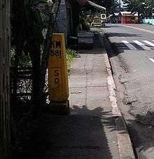
- Basud - barangay Basud borders Brgy. Guinlajon on the south and Ticol on the north. It hosts to a rice mill along the Maharlika Highway, right after passing through the Cawayan Bridge going north. It also hosts the entrance to the Cawayan River for trucks quarrying sand (though nowadays, it is prohibited). Beyond each side of the Maharlika Highway, are the wide vast of rice fields extending to several barangays – Ticol and Capuy - in the north.
_flowing_from_the_Pocdol_Mountains.jpg)
- Bibincahan - is the largest barangay in the East District. It borders Barangays Cabid-an and Balogo on the east, San Juan on the west, Salog on the south. North of it is unclassified forest land, which offers a good hiking experience. Major city roads, like the Sorsogon diversion road from Pangpang to Cabid-an, or the Sorsogon-Bacon road that connects the 2 districts, and Barangay Road that connects it with Balogo, pass by this barangay. The Sorsogon Cock Pit is also located on this barangay. A smaller Iglesia ni Kristo church can be found here on the corner of the Sorsogon Diversion and Bacon-Sorsogon Roads. The Sorsogon Memorial Park is also located here – it is the first private memorial park in the city.
It hosts to one of the oldest subdivision in the city – Sts. Peter and Paul Ville Subdivision and Our Lady’s Village – Bibincahan, both accessible via Magsaysay St.
- Bitan-o/Dalipay (Pob.)
- Bucalbucalan
- Buenavista
- Buhatan
- Bulabog - it is located between barangays Rizal and Capuy, along the Maharlika Highway. It hosts the Pepita Park and Rest Area[1] and a small wet market for seafood products.
It is a well known destination for those who wants to buy the fresh catch in the morning, especially sea shell products.
It has also dwindling mangrove along its coast.[2]
- Burabod (Pob.) - it is located at the heart of the city where the first central school is located, Sorsogon East Central School.
- Cabid-An
- Cambulaga
- Capuy - it is located between barangays Bulabog on the north and Ticol on the south. It is relatively flat land with rice field and a hilly part on the eastern side.
It has a single elementary school on the barangay center.
Aside from rice and coconut products, it also produces calamondin from one of the couple of orchards (the other one is Tabuena's located in brgy. Guinlajon) in the city.
- Gimaloto
- Guinlajon - it hosts the only hydroelectric power plant in the city. It is a popular destination for hikers since it has trails that lead to Bacman Geothermal Plant, to Bacon district or to Manito, Albay. It also hosts to the former Sorsogon National High School Annex, now known as Tabuena National High School.
The new SSS building is also located in this area. Finally, barangay road to barangays Pamurayan, and Gimaloto can be found on this barangay.

- Macabog
- Marinas
- Pamurayan
- Pangpang - hosts to Our Lady’s Village – Pangpang, and Sorsogon Medical Mission Doctors. Pangpang has Guinlajon on the west, Penafrancia on the south, Macabog on the east and Tugos on the southeast. North of Pangpang is unclassified forest land. It also hosts to a lone gasoline station, Shell, just beside the Pangpang Elementary School along the Maharlika Highway. The western entry point for the Sorsogon Diversion Road is in this barangay.
- Panlayaan
- Peñafrancia
- Piot (Pob.)
- Polvorista (Pob.) - The new Barangay Chairman is Tobias Domo from the 2010 Barangay Election. It is believed that its name came from the Spanish word, polvora, or gunpowder used for the production of fireworks or kwitis. It is said that to be a place were residents are experts in production of kwitis, which, in the 19th century, became a necessity for the celebration of fiestas, festivals and general merrymaking. Before this, just like in other parts of Bikol Region, kwitis, were used to warn people of an impending Moro raid.[3]
- Rizal
- Salog (Pob.)
- Salvacion - connects the town of Castilla and Sorsogon City. On its east, it shares a common border with Barangay Panlayaan.
- Sampaloc (Pob.)
- San Isidro
- San Juan (Roro)
- Sirangan (Pob.) - is a coastal barangay along Sorsogon Bay. One of the major rivers, Salog River cuts across this barangay. It also hosts several commercial establishments due to its proximity to the city center. Sts. Peter and Paul Cathedral, the old Pantranco bus station and Plaza Bonifacio are located in this barangay.

- Sulucan (Pob.)
- Talisay (Pob.) - is a coastal barangay located in Poblacion. It hosts to major schools like Sorsogon Pilot Elementary School and Saint Louise de Marillac College of Sorsogon. The Barangay Chairman for Talisay is Dennis Valladolid as of December, 2010.
- Ticol - is sandwiched between barangays Basud and Capuy. Wide areas of rice fields can be found in this barangay.
- Tugos
Barangays in Bacon District
In Bacon district, there are 28 barangays, namely:
- Balete
- Bato
- Bon-Ot
- Bogña
- Buenavista
- Cabarbuhan
- Caricaran - a coastal barangay where the popular Tolonggapo Beach is located. It borders 3 barangays, namely, Poblacion on its west, Bonga on its east, and San Pascual on its south. It is also where the old Bacon town hall is located (where the staircase can be seen protruding from the beach sand).
- Del Rosario
- Gatbo
- Jamislagan
- Maricrum
- Osiao - this is one of the far flung barangays of Bacon district and the most practical transportation to reach it is by motorized banca. However, it hosts to one of the potential tourism spot – Danao Lake – situated on a mountain side. Due to its remoteness, it is a well known hiding place of New People’s Army during the height of the communist rebellion on the ’80s.
- Poblacion - this is the former town center of Bacon. It hosts to one of the oldest church in Sorsogon located in a hilltop. A lone hospital is located in this barangay.
- Rawis
- Salvacion
- San Isidro - this is situated between San Ramon and San Roque (both barangays of the Bacon district). Radial access to this barangay is via a city road from Sitio Batohan in Barangay San Roque. The road that cuts across this barangay proceeds via San Ramon and San Vicente, eventually merging with the Maharlika Highway in Barangay Buhatan (part of the Sorsogon district). San Isidro is relatively flat and its agriculture is mostly rice field. Part of the Bacon Airport’s runway (southern tip) is located in this barangay, while most of the portion is located in Barangay San Roque. According to the old folks, San Isidro was a major supplier of Banig and native hats made of Karagumoy leaves.

- San Juan
- San Pascual
- San Ramon

- San Roque - it hosts to the Bacon Community Airport and borders Brgy. Bibincahan of the Sorsogon District. There is also a cockpit house in front of the community airport in Sitio Gabao.
- San Vicente
- Santa Cruz
- Santa Lucia
- Santo Domingo
- Santo Niño - the farthest barangay of Bacon District in the north, connecting to the municipality of Man-ito, Albay. It does not sit beside any barangays since it is bordered by unclassified forest land. The most practical transportation to reach it is by motorized banca due to lack of roads for light vehicles.
- Sawanga
- Sugod
Gallery
-

This is the section of Cawayan River located at Brgy. Barayong, Sorsogon City. The mountains on the background is part of Barangays Guinlajon and Basud.
-

Rompeolas is located in the periphery of Talisay, just beside Sorsogon Pilot Elementary School.
-

Bacon Beach, facing South. The beach is located at Brgy. Caricaran, just right after Brgy. Poblacion in Bacon District.
-

Bacon Church, located Poblacion of Bacon district.
-
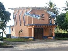
Pepita Park located in Brgy. Bucalbucalan.
-

Dirt runway of the Sorsogon Community Airport (RPLZ) located in Brgy. San Roque of Bacon district.
-
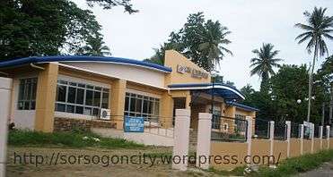
The new SSS Building in Brgy. Guinlajon.
-

The chapel is located at Sitio Bisita, Brgy. San Isidro.
-
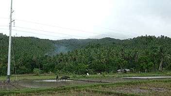
There's a wide tract of rice field in Brgy. Capuy due to its flat topography especially on the western side of the Maharlika Highway (AH26). On its western side are hills of coconut trees and different fruit bearing trees.
-

Sorsogon City's Catholic cemetery is located at Brgy. Sampaloc.
Notes
Most of the information here came from a map of Sorsogon City from the material - Comprehensive Land Use Plan 2003-2012, Summary (Briefing Material), Sectoral Consultation, Vicanta Hall, Sorsogon City, November 27, 2003.
References
- ↑ http://sorsogoncity.wordpress.com/2010/09/19/pepita-park-and-rest-area/
- ↑ http://sorsogoncity.wordpress.com/2011/01/23/mangrove-in-brgy-bulabog/
- ↑ Kwitis! p53. Tracing from Solsogon to Sorsogon, 2007, Imprenta Sorsogon, Sorsogon City