List of World Heritage Sites in the Netherlands

This is a list of World Heritage Sites in the Netherlands with properties of cultural and natural heritage in the Netherlands as inscribed in UNESCO's World Heritage List or as on the country's tentative list.[1] The Netherlands, with an extension to Curaçao,[note 1] accepted the Convention Concerning the Protection of the World Cultural and Natural Heritage on 26 August 1992, after which it could nominate properties on their territory to be considered for the World Heritage List.[2]
Currently, 10 properties in the Netherlands and Curaçao are inscribed on the World Heritage List. Nine of these are cultural properties and one is a natural property.[1] The first was added to the list in 1995 and the latest in 2014. Eight properties are in the Netherlands, one is in Curaçao, and one is in both the Netherlands and Germany.[note 2] The tentative list of the Netherlands contains eight properties, all of which were submitted on 17 August 2011.[1] The nomination of an additional property on the Tentative List, Teylers, Haarlem, was withdrawn at the request of the Netherlands during the 37th Session of the World Heritage Committee in 2013 in Phnom Penh, Cambodia after ICOMOS determined that the site did not suitably meet the criteria.[3]
The names in the tables below are the names of the properties as used on the website of UNESCO.[1] There are three different types of properties possible: cultural, natural, and mixed.[note 3] Selection criteria i, ii, iii, iv, v, and vi are the cultural criteria, and selection criteria vii, viii, ix, and x are the natural criteria.[4] The years for the properties on the World Heritage List are the years of inscription, the years for the tentative list are those of submission. The numbers are the reference numbers as used by UNESCO, and they link directly to the description pages of the properties on the UNESCO website.[1]
Properties on the World Heritage List
| ID | Image | Name | Location | Type (criteria) | Year | Description |
|---|---|---|---|---|---|---|
| 739 |  |
Schokland and Surroundings | Noordoostpolder, Flevoland | Cultural (iii, v)[5] | 1995[5] | Schokland symbolizes the struggle of the people of the Netherlands against the sea. It was an inhabited peninsula since pre-historic times, it became an island in the 15th century, until it was completely encroached by the Zuiderzee in 1859. In the 1940s the Noordoostpolder was created and consequently Schokland was reclaimed.[5] |
| 759 |  |
Defence Line of Amsterdam | North Holland and Utrecht | Cultural (ii, iv, v)[6] | 1996[6] | The defence line around the Dutch capital Amsterdam was built between 1883 and 1920. It is the only fortification that is based on the principle of controlling the waters around a city. It contains a network of 45 armed forts and can temporarily flood polders extending 135 kilometers around Amsterdam.[6] |
| 818 | .JPG) |
Mill Network at Kinderdijk-Elshout | Alblasserdam and Nieuw-Lekkerland, South Holland | Cultural (i, ii, iv) | 1997 | |
| 819 |  |
Historic Area of Willemstad, Inner City and Harbour, Curaçao | Willemstad, Curaçao[note 4] | Cultural (ii, iv, v) | 1997 | |
| 867 |  |
Ir.D.F. Woudagemaal (D.F. Wouda Steam Pumping Station) | Lemmer, Lemsterland, Friesland | Cultural (i, ii, iv) | 1998 | |
| 899 | 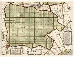 |
Droogmakerij de Beemster (Beemster Polder) | Beemster, North Holland | Cultural (i, ii, iv) | 1999 | |
| 965 | 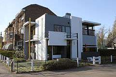 |
Rietveld Schröderhuis (Rietveld Schröder House) | Utrecht, Utrecht | Cultural (i, ii) | 2000 | |
| 1314 |  |
The Wadden Sea | Friesland, Groningen, and North Holland[note 2] | Natural (viii, ix, x) | 2009 | |
| 1349 | 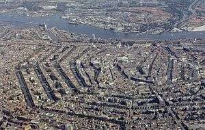 |
Seventeenth-century canal ring area of Amsterdam inside the Singelgracht | Amsterdam, North Holland | Cultural (i, ii, iv) | 2010 | |
| 1441 | 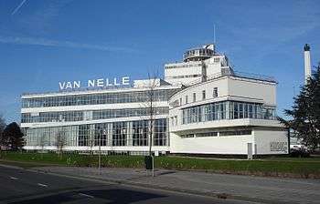 |
Van Nelle Factory | Rotterdam, South Holland 51°55′24″N 4°26′00″E / 51.92333°N 4.43333°E | Cultural (ii, iv) | 2014 |
The Netherlands’s Tentative List


Previous Tentative List Sites
List of sites whose nomination was not approved by the World Heritage Committee.
- Name: as listed by the World Heritage Committee
- Location: city or location of site
- UNESCO data: Site reference number, the year the site was inscribed on the Tentative List, and the criteria it was listed under
- Withdrawal of nomination: Year, World Heritage Committee Session
- Reason: Reason(s) inscription was not recommended
| Name | Image | Location | UNESCO data | Withdrawal of nomination | Reason(s) |
|---|---|---|---|---|---|
| Teylers, Haarlem | 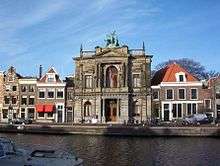 | Haarlem, North Holland | 5634 (2011) i, iii, iv | 2013, 37th Session (Phnom Penh, Cambodia) | Site did not demonstrate how, without a considerable number of detailed qualifiers, it could be seen as the most exceptional example among the many learning institutions of the European Age of Enlightenment, which have been preserved.[7] |
See also
Notes
- ↑ The Netherlands and Curaçao are both constituent countries of the Kingdom of the Netherlands.
- 1 2 The Wadden Sea is located in the Netherlands, Germany, and Denmark, but only the Dutch and German parts are inscribed on the World Heritage List.
- ↑ There are no mixed properties in the Netherlands and Curaçao on the World Heritage List or on the country's tentative list.
- 1 2 Curaçao is a constitute country of the Kingdom of the Netherlands in the Caribbean.
- ↑ Bonaire is a special municipality of the Netherlands located in the Caribbean.
- ↑ Saba is a special municipality of the Netherlands located in the Caribbean.
References
- 1 2 3 4 5 Netherlands. UNESCO World Heritage Centre. Retrieved on 2012-01-21.
- ↑ State Parties. UNESCO World Heritage Centre. Retrieved on 2012-01-21.
- ↑ "Decisions Adopted by the World Heritage Committee at its 37TH Session WHC-13/37.COM/20, Decision: 37 COM 8B.36" (PDF).
- ↑ The Criteria. UNESCO World Heritage Centre. Retrieved on 2009-07-23.
- 1 2 3 4 Schokland and Surroundings. UNESCO World Heritage Centre. Retrieved on 2012-01-22.
- 1 2 3 4 Defence Line of Amsterdam. UNESCO World Heritage Centre. Retrieved on 2012-01-22.
- ↑ "Evaluations of Nominations of Cultural and Mixed Properties WHC-13/37.COM/INF.8B1, pg. 197" (PDF).