List of World Heritage Sites in Indonesia
The UNESCO (United Nations Educational, Scientific and Cultural Organization) has designated 8 World Heritage Sites in Indonesia.[1][2]
Selection is based on ten criteria: six for cultural heritage (i–vi) and four for natural heritage (vii–x).[3] Some sites, designated "mixed sites," represent both cultural and natural heritage. In Indonesia, there are 4 cultural, 4 natural, and no mixed sites.[1]
The World Heritage Committee may also specify that a site is endangered, citing "conditions which threaten the very characteristics for which a property was inscribed on the World Heritage List." Tropical Rainforest Heritage of Sumatra. A number of organizations have been pushing the Ministry of Culture to nominate more sites for UNESCO inclusion since 2015.
Location of sites

Legend
The table is sortable by column by clicking on the ![]() at the top of the appropriate column; alphanumerically for the Site, Area, and Year columns; by state party for the Location column; and by criteria type for the Criteria column. Transborder sites sort at the bottom.
at the top of the appropriate column; alphanumerically for the Site, Area, and Year columns; by state party for the Location column; and by criteria type for the Criteria column. Transborder sites sort at the bottom.
- Site; named after the World Heritage Committee's official designation[4]
- Location; at city, regional, or provincial level and geocoordinates
- Criteria; as defined by the World Heritage Committee[3]
- Area; in hectares and acres. If available, the size of the buffer zone has been noted as well. A value of zero implies that no data has been published by UNESCO
- Year; during which the site was inscribed to the World Heritage List
- Description; brief information about the site, including reasons for qualifying as an endangered site, if applicable
Inscribed sites
| Site | Image | Location | Criteria | Area ha (acre) |
Year | Description | Refs |
|---|---|---|---|---|---|---|---|
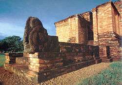
| Borobudur Temple Compounds | 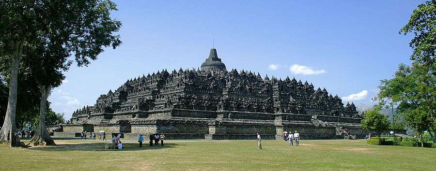 |
Magelang Regency, Central Java 7°36′28″S 110°12′13″E / 7.60778°S 110.20361°E |
Cultural: (i), (ii), (vi) |
— |
1991 | This famous Buddhist temple, dating from the 8th and 9th centuries, is located in central Java. It was built in three tiers: a pyramidal base with five concentric square terraces, the trunk of a cone with three circular platforms and, at the top, a monumental stupa. The walls and balustrades are decorated with fine low reliefs, covering a total surface area of 2,500 m2. Around the circular platforms are 72 openwork stupas, each containing a statue of the Buddha. The monument was restored with UNESCO's help in the 1970s. | 592[5] |
| Cultural Landscape of Bali Province: the Subak System as a Manifestation of the Tri Hita Karana Philosophy | 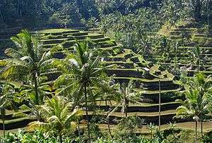 |
Bali 8°20′0″S 115°0′0″E / 8.33333°S 115.00000°E |
Cultural: (ii), (iii), (v), (vi) |
19,520 (48,200) | 2012 | The cultural landscape of Bali consists of five rice terraces and their water temples that cover 19,500 ha. The temples are the focus of a cooperative water management system of canals and weirs, known as subak, that dates back to the 9th century. Included in the landscape is the 18th-century Royal Water Temple of Pura Taman Ayun, the largest and most impressive architectural edifice of its type on the island. The subak reflects the philosophical concept of Tri Hita Karana, which brings together the realms of the spirit, the human world and nature. This philosophy was born of the cultural exchange between Bali and India over the past 2,000 years and has shaped the landscape of Bali. The subak system of democratic and egalitarian farming practices has enabled the Balinese to become the most prolific rice growers in the archipelago despite the challenge of supporting a dense population. | 1194rev[6] |
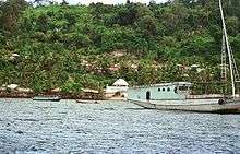
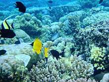
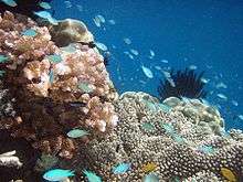
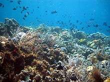
| Komodo National Park | 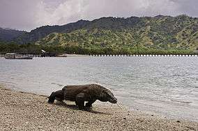 |
East Nusa Tenggara 8°33′S 119°29′E / 8.550°S 119.483°E |
Natural: (vii), (x) |
219,322 (541,960) | 1991 | These volcanic islands are inhabited by a population of around 5,700 giant lizards, whose appearance and aggressive behaviour have led to them being called 'Komodo dragons'. They exist nowhere else in the world and are of great interest to scientists studying the theory of evolution. The rugged hillsides of dry savannah and pockets of thorny green vegetation contrast starkly with the brilliant white sandy beaches and the blue waters surging over coral. | 609[7] |
| Lorentz National Park | 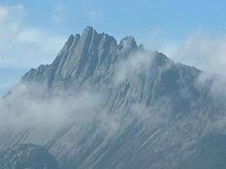 |
Papua 4°45′S 137°50′E / 4.750°S 137.833°E |
Natural: (vii), (ix), (x) |
2,350,000 (5,800,000) | 1999 | Lorentz National Park (2.35 million ha) is the largest protected area in South-East Asia. It is the only protected area in the world to incorporate a continuous, intact transect from snowcap to tropical marine environment, including extensive lowland wetlands. Located at the meeting-point of two colliding continental plates, the area has a complex geology with ongoing mountain formation as well as major sculpting by glaciation. The area also contains fossil sites which provide evidence of the evolution of life on New Guinea, a high level of endemism and the highest level of biodiversity in the region. | 955[8] |
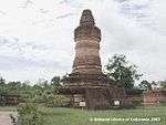
| Prambanan Temple Compounds |  |
Central Java 7°45′8″S 110°29′30″E / 7.75222°S 110.49167°E |
Cultural: (i), (iv) |
— |
1991 | Built in the 10th century, this is the largest temple compound dedicated to Shiva in Indonesia. Rising above the centre of the last of these concentric squares are three temples decorated with reliefs illustrating the epic of the Ramayana, dedicated to the three great Hindu divinities (Shiva, Vishnu and Brahma) and three temples dedicated to the animals who serve them. | 642[9] |
| Sangiran Early Man Site | 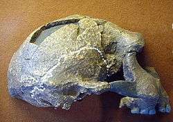 |
Central Java 7°24′0″S 110°49′0″E / 7.40000°S 110.81667°E |
Cultural: (iii), (vi) |
5,600 (14,000) | 1996 | Excavations here from 1936 to 1941 led to the discovery of the first hominid fossil at this site. Later, 50 fossils of Meganthropus palaeo and Pithecanthropus erectus/Homo erectus were found – half of all the world's known hominid fossils. Inhabited for the past one and a half million years, Sangiran is one of the key sites for the understanding of human evolution. | 593[10] |
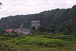
| Tropical Rainforest Heritage of Sumatra† | Sumatra, 2°30′S 101°30′E / 2.500°S 101.500°E |
Natural: (vii), (ix), (x) |
2,595,124 (6,412,690) | 2004 | The 2.5 million hectare Tropical Rainforest Heritage of Sumatra site comprises three national parks: Gunung Leuser National Park, Kerinci Seblat National Park and Bukit Barisan Selatan National Park. The site holds the greatest potential for long-term conservation of the distinctive and diverse biota of Sumatra, including many endangered species. The protected area is home to an estimated 10,000 plant species, including 17 endemic genera; more than 200 mammal species; and some 580 bird species of which 465 are resident and 21 are endemic. Of the mammal species, 22 are Asian, not found elsewhere in the archipelago and 15 are confined to the Indonesian region, including the endemic Sumatran orang-utan. The site also provides biogeographic evidence of the evolution of the island. The site has been listed as endangered since 2011 due to poaching, illegal logging, agricultural encroachment, and plans to build roads. | 1167[11][12] | |
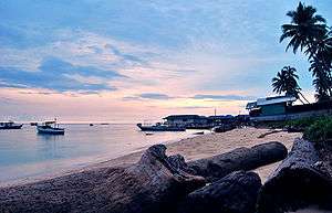
| Ujung Kulon National Park | 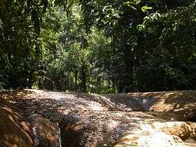 |
Banten and Lampung 6°45′S 105°20′E / 6.750°S 105.333°E |
Natural: (vii), (x) |
78,525 (194,040) | 1991 | This national park, located in the extreme south-western tip of Java on the Sunda shelf, includes the Ujung Kulon peninsula and several offshore islands and encompasses the natural reserve of Krakatoa. In addition to its natural beauty and geological interest – particularly for the study of inland volcanoes – it contains the largest remaining area of lowland rainforests in the Java plain. Several species of endangered plants and animals can be found there, the Javan rhinoceros being the most seriously under threat. | 608[13] |
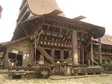
Tentative list
The following 18 sites are on the Tentative List for Indonesia, meaning that the government intends to consider them for nomination in the future:[14]
See also
- List of World Heritage Sites in Thailand
- List of World Heritage Sites in the Philippines
- List of World Heritage Sites in Malaysia
- List of World Heritage Sites in Singapore
Notes
- 1 2 "World Heritage Properties in Indonesia". UNESCO. Retrieved 1 July 2012.
- ↑ "Composition of macro geographical (continental) regions, geographical sub-regions, and selected economic and other groupings". Geographical region and composition of each region. United Nations Statistics Division. 2010. Retrieved 20 October 2011.
- 1 2 "The Criteria for Selection". UNESCO. Retrieved 10 September 2011.
- ↑ "World Heritage List Nominations". UNESCO. Retrieved 28 May 2010.
- ↑ "Borobudur Temple Compounds". UNESCO. Retrieved 28 May 2010.
- ↑ "Cultural Landscape of Bali Province". UNESCO. Retrieved 1 July 2012.
- ↑ "Komodo National Park". UNESCO. Retrieved 28 May 2010.
- ↑ "Lorentz National Park". UNESCO. Retrieved 28 May 2010.
- ↑ "Prambanan Temple Compounds". UNESCO. Retrieved 28 May 2010.
- ↑ "Sangiran Early Man Site". UNESCO. Retrieved 28 May 2010.
- ↑ "Tropical Rainforest Heritage of Sumatra". UNESCO. Retrieved 25 June 2011.
- ↑ "Danger listing for Indonesia's Tropical Rainforest Heritage of Sumatra". UNESCO. Retrieved 26 July 2011.
- ↑ "Ujung Kulon National Park". UNESCO. Retrieved 28 May 2010.
- ↑ "Tentative Lists: Indonesia". UNESCO. Retrieved 8 April 2012.
- ↑ "Banda Islands". UNESCO. Retrieved 12 August 2015.
- ↑ "Bawomataluo Site". UNESCO. Retrieved 8 April 2012.
- ↑ "Betung Kerihun National Park". UNESCO. Retrieved 8 April 2012.
- ↑ "Bunaken National Park". UNESCO. Retrieved 8 April 2012.
- ↑ "Derawan Islands". UNESCO. Retrieved 8 April 2012.
- ↑ "Muara Takus Compound Site". UNESCO. Retrieved 8 April 2012.
- ↑ "Muarajambi Temple Compound". UNESCO. Retrieved 8 April 2012.
- ↑ "Prehistoric Cave Sites in Maros-Pangkep". UNESCO. Retrieved 8 April 2012.
- ↑ "Raja Ampat Islands". UNESCO. Retrieved 8 April 2012.
- ↑ "Taka Bonerate National Park". UNESCO. Retrieved 8 April 2012.
- ↑ "Tana Toraja Traditional Settlement". UNESCO. Retrieved 8 April 2012.
- ↑ "Trowulan - Former Capital City of Majapahit Kingdom". UNESCO. Retrieved 8 April 2012.
- ↑ "Wakatobi National Park". UNESCO. Retrieved 8 April 2012.
- ↑ "Sangkulirang - Mangkahilat Karts: Prehistoric rock art area". UNESCO. Retrieved 12 August 2015.
- ↑ "The Old Town of Jakarta (Formerly old Batavia) and 4 Outlying Islands (Onrust, Kelor, Cipir dan Bidadari)". UNESCO. Retrieved 12 August 2015.
- ↑ "Semarang Old Town". UNESCO. Retrieved 12 August 2015.
- ↑ "Sawahlunto Old Coal Mining Town". UNESCO. Retrieved 12 August 2015.
- ↑ "Traditional Settlement at Nagari Sijunjung". UNESCO. Retrieved 12 August 2015.
| Wikimedia Commons has media related to World Heritage Sites in Indonesia. |
References
- General
- "World Heritage Committee: Sixteenth session" (PDF). UNESCO. Retrieved 28 May 2010.
- "World Heritage Committee: Twenty-eighth session" (PDF). UNESCO. Retrieved 26 June 2011.
Indonesia articles | |||||||||||
|---|---|---|---|---|---|---|---|---|---|---|---|
| History |  | ||||||||||
| Geography |
| ||||||||||
| Politics | |||||||||||
| Economy | |||||||||||
| Culture |
| ||||||||||