List of U.S. states by coastline
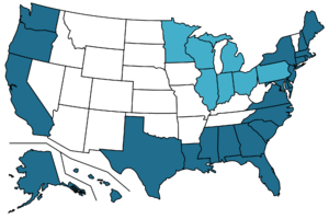
States shaded dark blue have ocean coastline.
States shaded light blue have only Great Lakes coastline.
States shaded white have no coastline.
States shaded light blue have only Great Lakes coastline.
States shaded white have no coastline.
This is a list of U.S. states ranked by their coastline length. States with no coastline are not included.
Two separate measurements are used: method 1 only includes states with ocean coastline and excludes tidal inlets; method 2 includes Great Lake coastline and the extra length from tidal inlets. For example, method 2 counts the Great Bay as part of New Hampshire's coastline, but method 1 does not. The figures suffer from the inaccuracy inherent in all attempts at measuring coastlines but are nevertheless useful for comparison.
- The data for method 1 were retrieved from a CRS Report for Congress [1] using data from U.S. Department of Commerce, National Oceanic and Atmospheric Administration, The Coastline of the United States, 1975. This is based on measurements made using large-scale nautical charts. The figure for Connecticut was arrived at separately and may not reflect the correct comparative distance. These numbers exclude the Great Lakes coastlines.
- The data for method 2 are from a list maintained by the Office of Ocean and Coastal Resource Management of the National Oceanic and Atmospheric Administration (NOAA). The state coastline lengths were computed by an unspecified method that includes tidal areas not included in the first method.[2] These numbers also include the Great Lakes coastlines.
Table
| State | Method 1 (CRS) | Method 2 (NOAA) | Ratio (M2÷M1) |
Area [3] (mi2) |
Coast/area ratio (ft/mi2) | |||
|---|---|---|---|---|---|---|---|---|
| Coastline | Rank | Coastline | Rank | Method 1 | Method 2 | |||
| | 6,640 mi (10,690 km) | 1 | 33,904 mi (54,563 km) | 1 | 5.11 | 665384 | 53 | 270 |
| | 1,350 mi (2,170 km) | 2 | 8,436 mi (13,576 km) | 2 | 6.25 | 65758 | 110 | 680 |
| | 840 mi (1,350 km) | 3 | 3,427 mi (5,515 km) | 5 | 4.08 | 163695 | 27 | 110 |
| | 750 mi (1,210 km) | 4 | 1,052 mi (1,693 km) | 18 | 1.40 | 10932 | 360 | 510 |
| | 397 mi (639 km) | 5 | 7,721 mi (12,426 km) | 3 | 19.4 | 52378 | 40 | 780 |
| | 367 mi (591 km) | 6 | 3,359 mi (5,406 km) | 7 | 9.15 | 268596 | 7.2 | 66 |
| | 301 mi (484 km) | 7 | 3,375 mi (5,432 km) | 6 | 11.2 | 53819 | 30 | 330 |
| | 296 mi (476 km) | 8 | 1,410 mi (2,270 km) | 17 | 4.76 | 98379 | 16 | 76 |
| | 228 mi (367 km) | 9 | 3,478 mi (5,597 km) | 4 | 15.3 | 35380 | 34 | 520 |
| | 192 mi (309 km) | 10 | 1,519 mi (2,445 km) | 16 | 7.91 | 10554 | 96 | 760 |
| | 187 mi (301 km) | 11 | 2,876 mi (4,628 km) | 12 | 15.4 | 32020 | 31 | 470 |
| | 157 mi (253 km) | 12 | 3,026 mi (4,870 km) | 11 | 19.3 | 71298 | 12 | 220 |
| | 130 mi (210 km) | 13 | 1,792 mi (2,884 km) | 15 | 13.8 | 8723 | 79 | 1,100 |
| | 127 mi (204 km) | 14 | 2,625 mi (4,225 km) | 13 | 20.7 | 54555 | 12 | 250 |
| | 112 mi (180 km) | 15 | 3,315 mi (5,335 km) | 8 | 29.6 | 42775 | 14 | 410 |
| | 100 mi (160 km) | 16 | 2,344 mi (3,772 km) | 14 | 23.4 | 59425 | 8.9 | 210 |
| | 96 mi (154 km) | 17 | 618 mi (995 km) | 20 | 6.44 | 5543 | 91 | 590 |
| | 53 mi (85 km) | 18 | 607 mi (977 km) | 21 | 11.5 | 52420 | 5.3 | 61 |
| | 44 mi (71 km) | 19 | 359 mi (578 km) | 24 | 8.16 | 48432 | 4.8 | 39 |
| | 40 mi (64 km) | 20 | 384 mi (618 km) | 22 | 9.60 | 1545 | 140 | 1,300 |
| | 31 mi (50 km) | 21 | 3,190 mi (5,130 km) | 10 | 103 | 12406 | 13 | 1,400 |
| | 28 mi (45 km) | 22 | 381 mi (613 km) | 23 | 13.6 | 2489 | 59 | 810 |
| | 13 mi (21 km) | 23 | 131 mi (211 km) | 28 | 10.1 | 9349 | 7.3 | 74 |
| | – | – | 3,224 mi (5,189 km) | 9 | – | 96714 | – | 180 |
| | – | – | 820 mi (1,320 km) | 19 | – | 65496 | – | 66 |
| | – | – | 312 mi (502 km) | 25 | – | 44826 | – | 37 |
| | – | – | 189 mi (304 km) | 26 | – | 86936 | – | 11 |
| | – | – | 140 mi (230 km) | 27 | – | 46054 | – | 16 |
| | – | – | 63 mi (101 km) | 29 | – | 57914 | – | 5.7 |
| | – | – | 45 mi (72 km) | 30 | – | 36420 | – | 6.5 |
| Total | 12,479 mi (20,083 km) | 94,122 mi (151,475 km) | ||||||
See also
- Coastline paradox
- List of countries by length of coastline
- List of countries by coast/area ratio
- How Long Is the Coast of Britain? Statistical Self-Similarity and Fractional Dimension
References
- ↑ "U.S. International Borders: Brief Facts", Congressional Research Service, November 9, 2006
- ↑ "NOAA Office for Coastal Management | States and Territories Working on Ocean and Coastal Management". coast.noaa.gov. NOAA Office for Coastal Management. 14 October 2016. Retrieved 2016-10-27.
- ↑ "United States Summary: 2010, Population and Housing Unit Counts, 2010 Census of Population and Housing" (PDF) (PDF). United States Census Bureau. September 2012. pp. V–2, 1 & 41 (Tables 1 & 18). Retrieved March 22, 2014.
External links
| Demographics | |
|---|---|
| Economy | |
| Environment | |
| Geography | |
| Government | |
| Health | |
| History | |
| Law | |
| Miscellaneous | |
| |
This article is issued from Wikipedia - version of the 10/27/2016. The text is available under the Creative Commons Attribution/Share Alike but additional terms may apply for the media files.