List of scheduled monuments in Taunton Deane

Taunton Deane shown within Somerset and England

Taunton Deane is a local government district with borough status in Somerset, England. Its council is based in Taunton. The district was formed on 1 April 1974, under the Local Government Act 1972, by a merger of the Municipal Borough of Taunton, Wellington Urban District, Taunton Rural District, and Wellington Rural District. Taunton Deane was granted borough status in 1975, enabling the mayoralty of Taunton to be continued, when other districts did not have mayors.[1] The district was given the name of an alternate form of the Taunton Deane Hundred.

A scheduled monument is a nationally important archaeological site or monument which is given legal protection by being placed on a list (or "schedule") by the Secretary of State for Culture, Media and Sport; English Heritage takes the leading role in identifying such sites. The legislation governing this is the Ancient Monuments and Archaeological Areas Act 1979. The term "monument" can apply to the whole range of archaeological sites, and they are not always visible above ground. Such sites have to have been deliberately constructed by human activity. They range from prehistoric standing stones and burial sites, through Roman remains and Medieval structures such as castles and monasteries, to later structures such as industrial sites and buildings constructed for the World Wars or the Cold War.[2]

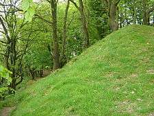
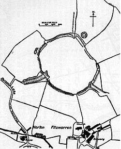
There are 33 scheduled monuments in Taunton Deane. Many of them are Neolithic through to the Bronze and Iron Ages such as bowl barrows, cairns along with hill forts such as Norton Camp.[3] Castle Neroche was an Iron Age hill fort which was reused as a Norman motte-and-bailey castle.[4] Burrow Mump shows evidence of Roman use but is better known as a Norman motte-and-bailey castle,[5] and later church.[6] It was presented, in 1946, by Major Alexander Gould Barrett, to the National Trust to serve as a memorial to the 11,281[7] Somerset men who lost their lives during the first and second world wars.[8]

The Medieval period is represented by several churchyard crosses. The defensive walls and part of Taunton Castle, which has Anglo-Saxon origins and was expanded during the Medieval and Tudor eras, is included.[9][10] More recent sites include Poundisford Park, Buckland Priory, Bradford Bridge and a duck decoy from the 17th century. Some of the sites such as Balt Moor Wall are of uncertain date; however the most recent are air traffic control buildings, pillboxes and fighter pens from RAF Culmhead, situated at Churchstanton on the Blackdown Hills.[11][12] The monuments are listed below using the titles given in the English Heritage data sheets.

Monuments

Name Location Type Completed [note 1] Grid ref.[note 2]
Geo-coordinates
Notes Entry number [note 3]ImageRef.
Balt Moor Wall Lyng Earthwork Before 1135 (possibly 9th century) ST 33826 29095
51°03′27″N 2°56′44″W / 51.0574°N 2.9456°W / 51.0574; -2.9456 (Balt Moor Wall)
The remains of a 550 metres (1,800 ft) section of medieval causeway, which now forms a raised embankment between 6 metres (20 ft) and 10 metres (33 ft) wide and up to 2 metres (6 ft 7 in) high. 1018952 [13][14][15]
Borough Bank Taunton Earthwork Middle Ages ST 22881 24692
51°00′59″N 3°06′03″W / 51.0164°N 3.1008°W / 51.0164; -3.1008 (Borough Bank)
The remains of medieval town walls. It now forms a bank and ditch around 2 metres (6 ft 7 in) high and 3.5 metres (11 ft) wide. 1019401 [16]
Bowl barrow at the west end of Cothelstone Hill, 825m NNE of St Agnes' Well Cothelstone Bowl barrow Bronze Age or Iron Age ST 18763 32603
51°05′13″N 3°09′41″W / 51.0870°N 3.1613°W / 51.0870; -3.1613 (Bowl barrow at the west end of Cothelstone Hill, 825m NNE of St Agnes' Well)
A bowl barrow with a diameter of 19 metres (62 ft) and 1.7 metres (5 ft 7 in) high. 1015085 [17]
Bowl barrow 840m north east of Bagborough House West Bagborough Bowl barrow Bronze Age ST 17182 34495
51°06′14″N 3°11′03″W / 51.1038°N 3.1843°W / 51.1038; -3.1843 (Bowl barrow 840m north east of Bagborough House)
An irregular oval bowl barrow which is 24 metres (79 ft) long, 14 metres (46 ft) wide and approximately 1 metre (3 ft 3 in) high, surrounded by a 3 metres (9.8 ft) wide ditch which has since been filled in. 1016500 [18]
Bowl barrow and folly ruins on Cothelstone Hill, 1km north east of St Agnes' Well Cothelstone Bowl barrow Bronze Age and post Medieval ST 18979 32677
51°05′16″N 3°09′30″W / 51.0877°N 3.1582°W / 51.0877; -3.1582 (Bowl barrow and folly ruins on Cothelstone Hill, 1km north east of St Agnes' Well)
A Bowl barrow which is 12 metres (39 ft) in diameter and 1.5 metres (4 ft 11 in) high on which a folly was built in the 18th century. The folly tower was destroyed in 1910. 1015086 [19]
Bowl barrow on Cothelstone Hill, 1.07km north east of St Agnes' Well Cothelstone Bowl barrow Bronze Age or Iron Age ST 19121 32656
51°05′15″N 3°09′22″W / 51.0875°N 3.1562°W / 51.0875; -3.1562 (Bowl barrow on Cothelstone Hill, 1.07km north east of St Agnes' Well)
An irregular bowl barrow, 2.67 metres (8 ft 9 in) long and 14 metres (46 ft) wide surrounded by a ditch. 1015087 [20]
Bowl barrow on Cothelstone Hill, 885m NNE of St Agnes' Well Cothelstone Bowl barrow Bronze Age or Iron Age ST 18830 32633
51°05′14″N 3°09′37″W / 51.0872°N 3.1603°W / 51.0872; -3.1603 (Bowl barrow on Cothelstone Hill, 885m NNE of St Agnes' Well)
A bowl barrow, 19 metres (62 ft) in diameter and 1.7 metres (5 ft 7 in) in height. 1015950 [21]
Bradford Bridge Bradford on Tone Bridge 14th century ST 17192 22998
51°00′01″N 3°10′53″W / 51.0004°N 3.1814°W / 51.0004; -3.1814 (Bradford Bridge)
A 15th century stone bridge with two arches, carrying a road over the River Tone. 1006220
[22]
Buckland Priory fishponds Durston Fish pond 12th century ST 30147 28242
51°03′12″N 3°00′33″W / 51.0533°N 3.0092°W / 51.0533; -3.0092 (Buckland Priory fishponds)
An area approximately 150 metres (490 ft) by 61 metres (200 ft) opposite the priory which contains the remains of three fishponds. The ponds were probably dug in the 13th century and were filled in by 1725. 1006145
[23][24][25]
Burrow Mump: a motte castle, later chapel and associated earthworks Burrowbridge Motte-and-bailey castle Norman ST 35930 30540
51°04′06″N 2°55′14″W / 51.0684°N 2.9205°W / 51.0684; -2.9205 (Burrow Mump: a motte castle, later chapel and associated earthworks)
Sited on a hill where the River Tone and the old course of the River Cary join the River Parrett, above the surrounding low lying land of the Somerset Levels. Archeological surveys have shown some Roman material and three medieval pits. It is likely that it was a Norman motte which may have been built during The Anarchy between 1135 and 1153. A medieval church dedicated to St Michael, belonging to the Athelney Abbey, dates from at least the mid 15th century. In 1793, the church was rebuilt. The hill and ruined roofless nave with the remains of the porch, some window openings without tracery were presented, in 1946, to the National Trust and serve as a memorial to the 11,281 Somerset men who lost their lives during the first and second world wars. 1011823
[5][26]
[27][28]
Cairn 280m south of Triscombe Stone West Bagborough Cairn Bronze Age ST 16425 35617
51°06′49″N 3°11′43″W / 51.1137°N 3.1953°W / 51.1137; -3.1953 (Cairn 280m south of Triscombe Stone)
A Bronze Age cairn close to Wills Neck the highest point of the Quantock Hills. It is 23 metres (75 ft) in diameter and 0.5 metres (1 ft 8 in) high. 1016707 [29][30]
Camp S of Manor Farm Wiveliscombe Roman fort 1st century ST 09014 27044
51°02′08″N 3°17′56″W / 51.0355°N 3.2990°W / 51.0355; -3.2990 (Camp S of Manor Farm)
Crop marks show evidence of a rectangular enclosure 1.5 metres (4 ft 11 in) above the surrounding fields. Excavations in the 1950s indicated it was likely to be the remains of a Roman fort. 1006167 [31]
Castle Neroche: a motte and bailey castle and earlier defences above Castle Plantation Curland Hill fort Iron Age reused in Norman period ST 27202 15708
50°56′15″N 3°02′12″W / 50.9375°N 3.0367°W / 50.9375; -3.0367 (Castle Neroche: a motte and bailey castle and earlier defences above Castle Plantation)
A Norman motte-and-bailey castle on the site of an earlier Iron Age hill fort. The castle was probably built by Robert, Count of Mortain in the 11th century. 1008252
[32][33]
[34][35]
Cross in St John the Baptist's churchyard, Heathfield Heathfield, Oake Cross Middle Ages ST 16005 26457
51°01′53″N 3°11′57″W / 51.0313°N 3.1992°W / 51.0313; -3.1992 (Cross in St John the Baptist's churchyard, Heathfield)
A medieval cross on an octagonal base. The shaft is approximately 2 metres (6 ft 7 in) high but the head is missing. 1016942
[36]
Cross in St James' churchyard Fitzhead Cross 14th century ST118284
51°02′52″N 3°15′26″W / 51.0479°N 3.2571°W / 51.0479; -3.2571 (Cross in St James' churchyard)
A medieval cross on an octagonal base. The shaft is approximately 1.5 metres (4 ft 11 in) high. The decorated lantern head was added as part of restoration in 1908. 1017291 [37][38]
Duck decoy 250m north west of Moredon House North Curry Duck decoy 17th century ST320264
51°01′57″N 2°58′07″W / 51.0325°N 2.9687°W / 51.0325; -2.9687 (Duck decoy 250m north west of Moredon House)
Duck decoy from the 17th century. The oval pool is now 50 metres (160 ft) by 40 metres (130 ft). 1014441 [39]
Hillfort on Castle Hill 650m south east of Ford House Wiveliscombe Hill fort Neolithic ST095282
51°02′46″N 3°17′23″W / 51.0462°N 3.2898°W / 51.0462; -3.2898 (Hillfort on Castle Hill 650m south east of Ford House)
King's Castle is a Neolithic hillfort surrounded by two banks with a ditch between them. The inner wall ranges up to 2.5 metres (8.2 ft) high and the outer wall gets up to 1.5 metres (4.9 ft) high. Arrowheads, scrapers, and borers have been found at the site. 1016498
[40]
Norton Camp large univallate hillfort Norton Fitzwarren Hill fort Bronze Age ST 19613 26267
51°01′50″N 3°09′04″W / 51.0306°N 3.1511°W / 51.0306; -3.1511 (Norton Camp large univallate hillfort)
The earthwork consists of a single circular rampart (univallate) up to 3 m high, with three holloway entrances dominated by linear banks extending out from the main perimeter. The ring has a diameter of about 250 metres (820 ft), enclosing an area of 5 hectares (12 acres). The fort is at the top of low hill about 1 kilometre (0.62 mi) north of the River Tone. It is on the Heritage at Risk register. 1008467
[41]
Poundisford Park pale Pitminster Deer park Middle Ages ST 21147 19897
50°58′34″N 3°06′29″W / 50.9760°N 3.1081°W / 50.9760; -3.1081 (Poundisford Park pale)
The park surrounding Poundisford Park covers around 180 hectares (444.8 acres) including 2 hectares (4.9 acres) of gardens and pleasure grounds, and 178 hectares (440 acres) which were enclosed within the medieval park pale, which formed an elliptical shape, of which 40 hectares (99 acres) remains as parkland today. The park pale was a barrier to contain deer made of an earthen bank from 4 metres (13.1 ft) to 7 metres (23.0 ft) wide and up to 2 metres (6.6 ft) high. It is on the Heritage at Risk register. 1002957
[42][43][44]
Round barrow cemetery 100m south of School Farm Otterford Round barrow Bronze Age ST 22998 14368
50°55′25″N 3°05′49″W / 50.9236°N 3.0969°W / 50.9236; -3.0969 (Round barrow cemetery 100m south of School Farm)
Five round barrows in a line which form part of the larger Bronze Age cemetery on the Blackdown Hills known as Robin Hood's Butts. 1017055 [45]
Shell keep castle, part of the associated outer bailey, ninth century cemetery and a Civil War siegework at Taunton Castle Taunton Shell keep 13th century ST 22611 24581
51°00′55″N 3°06′50″W / 51.0153°N 3.1138°W / 51.0153; -3.1138 (Shell keep castle, part of the associated outer bailey, ninth century cemetery and a Civil War siegework at Taunton Castle)
Taunton Castle has origins in the Anglo Saxon period and was later the site of a priory. The Normans then built a stone structured castle, which belonged to the Bishops of Winchester. The current heavily reconstructed buildings are the inner ward, which now houses the Museum of Somerset and the Somerset Military Museum. 1013541
[46][47][48]
The Castles Bathealton Univallate hill fort Iron Age ST 05742 24484
51°00′43″N 3°20′42″W / 51.0120°N 3.3450°W / 51.0120; -3.3450 (The Castles)
Castles Camp is a univallate Iron Age hill fort. It covers an area of 1.6 hectares (4.0 acres) surrounded by a bank and ditch. 1019150 [49][50]
Three round cairns on Wills Neck Wills Neck Cairn Bronze Age ST1649035170
51°06′35″N 3°11′39″W / 51.1097°N 3.1943°W / 51.1097; -3.1943 (Three round cairns on Wills Neck)
Three Bronze Age cairns close to Wills Neck the highest point of the Quantock Hills. They range from 20 metres (66 ft) to 30 metres (98 ft) in diameter. There is a Triangulation station on the easternmost cairn. 1016502 [51]
Two bowl barrows 210m and 600m north west of Brown Down Cottage Otterford Bowl barrow Late Neolithic to Bronze Age ST233126
50°54′27″N 3°05′26″W / 50.9076°N 3.0906°W / 50.9076; -3.0906 (Two bowl barrows 210m and 600m north west of Brown Down Cottage)
Two bowl barrows which form part of the larger Bronze Age cemetery on the Blackdown Hills known as Robin Hood's Butts. 1016414 [52]
Two bowl barrows, one 380m west and one 685m north west of Beech Croft Otterford Bowl barrow Late Neolithic to Late Bronze Age ST234132
50°54′46″N 3°05′19″W / 50.9129°N 3.0885°W / 50.9129; -3.0885 (Two bowl barrows, one 380m west and one 685m north west of Beech Croft)
Two bowl barrows in a line which form part of the larger Bronze Age cemetery on the Blackdown Hills known as Robin Hood's Butts. 1016415
[53]
Two bowl barrows 190m east of Brown Down Lodge Otterford Bowl barrow Late Neolithic to Late Bronze Age ST241124
50°54′21″N 3°04′46″W / 50.9057°N 3.0794°W / 50.9057; -3.0794 (Two bowl barrows 190m east of Brown Down Lodge)
Two bowl barrows one of 10 metres (33 ft) diameter and the other of 12 metres (39 ft). Each is approximately 1 metre (3 ft 3 in) high. 1016739 [54]
Two bowl barrows and a round cairn on Lydeard Hill, 750m north of Tilbury Farm West Bagborough Bowl barrow Bronze Age ST176343
51°06′06″N 3°10′34″W / 51.1017°N 3.1760°W / 51.1017; -3.1760 (Two bowl barrows and a round cairn on Lydeard Hill, 750m north of Tilbury Farm)
Two bowl barrows and a cairn, which has a higher proportion of stone than soil, all dating from the Bronze Age. Each is around 20 metres (66 ft) in diameter and 1 metre (3 ft 3 in) high. 1016499 [55]
Two bowl barrows, 530m and 670m north east of Plantation Cottage West Bagborough Bowl barrow Bronze Age ST 16873 34860
51°06′25″N 3°11′19″W / 51.1070°N 3.1887°W / 51.1070; -3.1887 (Two bowl barrows, 530m and 670m north east of Plantation Cottage)
Twp Bowl barrows on Wills Neck the highest point of the Quantock Hills. 1016501 [56]
Two cairns, 780m ESE of Triscombe Farm West Bagborough Cairn Bronze Age ST 16197 35237
51°06′37″N 3°11′55″W / 51.1103°N 3.1985°W / 51.1103; -3.1985 (Two cairns, 780m ESE of Triscombe Farm)
Two cairns on Wills Neck the highest point of the Quantock Hills. 1016706 [29]
Two crosses in St Mary's churchyard Bishops Lydeard Cross 14th century ST 16761 29732
51°03′41″N 3°11′14″W / 51.0614°N 3.1872°W / 51.0614; -3.1872 (Two crosses in St Mary's churchyard)
Two crosses, one of hamstone and the other red sandstone. The cross nearest the church has a 19th century base holding the cross shaft which is from the 14th century. The second cross has a carving of John the Baptist on the east face. 1016708
[57]
Two groups of World War II pillboxes in the north eastern and north western sectors of the former airfield of RAF Culmhead, Trickey Warren Churchstanton Pillbox 1941 ST 20751 15610
50°56′12″N 3°08′05″W / 50.9368°N 3.1348°W / 50.9368; -3.1348 (Two groups of World War II pillboxes in the north eastern and north western sectors of the former airfield of RAF Culmhead, Trickey Warren)
Two pillboxes dating from World War II which protected the airfield. 1019846
[58]
Two World War II air traffic control buildings, 620m west and 560m WSW of Whitewall Corner, on the former airfield of RAF Culmhead, Trickey Warren Churchstanton Air traffic control tower 1941 ST 20751 15610
50°56′04″N 3°07′45″W / 50.9345°N 3.1292°W / 50.9345; -3.1292 (Two World War II air traffic control buildings, 620m west and 560m WSW of Whitewall Corner, on the former airfield of RAF Culmhead, Trickey Warren)
The World War II control towers for the airfield. One which was known as the Old Watch Office is slightly older and a second built to replace it. 1019845
[59]
World War II fighter pens and other airfield remains and defences of the former airfield of RAF Culmhead, at Trickey Warren Farm Churchstanton Blast pen 1941 ST 20354 14425
50°55′26″N 3°08′04″W / 50.9238°N 3.1345°W / 50.9238; -3.1345 (World War II fighter pens and other airfield remains and defences of the former airfield of RAF Culmhead, at Trickey Warren Farm)
A group of blast pens built to protect fighter aircraft during World War II. 1020492

See also

Notes

  1. The date given is the date used by Historic England as significant for the initial building or that of an important part in the structure's description.
  2. Sometimes known as OSGB36, the grid reference is based on the British national grid reference system used by the Ordnance Survey.
  3. The "List Entry Number" is a unique number assigned to each listed building and scheduled monument by Historic England.

References

  1. "About the Mayor". Taunton Deane Borough Council. Retrieved 23 January 2010.
  2. "Scheduled Monuments". English Heritage. Retrieved 9 September 2014.
  3. "Norton Camp". National Monuments Record. English Heritage. Retrieved 26 March 2011.
  4. "Castle Neroche". National Monument Record. English Heritage. Retrieved 22 March 2011.
  5. 1 2 "Burrow Mump, Burrowbridge". Somerset Historic Environment Record. Somerset County Council. Retrieved 4 October 2010.
  6. "Remains of Church on Burrow Mump". National Heritage List for England. English Heritage. Retrieved 2 March 2014.
  7. Dunning, Robert (1983). A History of Somerset. p. 101. ISBN 0-85033-461-6.
  8. Leete-Hodge, Lornie (1985). Curiosities of Somerset. Bodmin: Bossiney Books. p. 82. ISBN 0-906456-98-3.
  9. Bush, Robin (1994). Somerset: The Complete Guide. Dovecote Press. pp. 202–206. ISBN 1-874336-26-1.
  10. "Taunton's History". Taunton Town Centre!. Archived from the original on 3 June 2007. Retrieved 21 November 2007.
  11. Berryman, David (2006). Somerset airfields in the Second World War. Newbury: Countryside Books. pp. 50–86. ISBN 1-85306-864-0.
  12. "Culmhead airfield, Trickey Warren". Somerset Historic Environment Record. Somerset County Council. Retrieved 2009-07-25.
  13. "Balt Moor Wall". National Heritage List for England. English Heritage. Retrieved 20 August 2014.
  14. "Balt Moor Wall". Pastscape. English Heritage. Retrieved 20 August 2014.
  15. "Balt Moor Wall, between East Lyng and Athelney, Lyng". Somerset Historic Environment Record. Somerset County Council. Retrieved 20 August 2014.
  16. "Borough Bank". Pastscape. English Heritage. Retrieved 20 August 2014.
  17. "Bowl barrow at the west end of Cothelstone Hill, 825m NNE of St Agnes' Well". National Heritage List for England. English Heritage. Retrieved 20 August 2014.
  18. "Bowl barrow 840m north east of Bagborough House". National Heritage List for England. English Heritage. Retrieved 20 August 2014.
  19. "Bowl barrow and folly ruins on Cothelstone Hill, 1km north east of St Agnes' Well". National Heritage List for England. English Heritage. Retrieved 20 August 2014.
  20. "Bowl barrow on Cothelstone Hill, 1.07km north east of St Agnes' Well". National Heritage List for England. English Heritage. Retrieved 20 August 2014.
  21. "Bowl barrow on Cothelstone Hill, 885m NNE of St Agnes' Well". National Heritage List for England. English Heritage. Retrieved 20 August 2014.
  22. "Bradford Bridge". Images of England. English Heritage. Retrieved 17 August 2014.
  23. Bush, Robin (1994). Somerset: The Complete Guide. Dovecote Press. pp. 90–91. ISBN 1-874336-26-1.
  24. Dunning, Robert; C R Elrington; A P Baggs; M C Siraut. "Durston". Victoria County History. British History Online. Retrieved 8 January 2009.
  25. "Fishponds, Mynchin Buckland Priory, Durston". Somerset Historic Environment Record. Somerset County Council. Retrieved 24 October 2014.
  26. "Report for Aerial Survey Component Block 2: Somerset Levels" (PDF). The Aggregate Landscape of Somerset: Predicting the Archaeological Resource. English Heritage. p. 10. Retrieved 3 March 2014.
  27. Adkins, Lesley and Roy (1992). A field Guide to Somerset Archeology. Stanbridge: Dovecote press. pp. 32–33. ISBN 0-946159-94-7.
  28. Leete-Hodge, Lornie (1985). Curiosities of Somerset. Bodmin: Bossiney Books. p. 82. ISBN 0-906456-98-3.
  29. 1 2 "Two cairns, 780m ESE of Triscombe Farm". National Heritage List for England. English Heritage. Retrieved 20 August 2014.
  30. "Cairn 280m south of Triscombe Stone". National Heritage List for England. English Heritage. Retrieved 20 August 2014.
  31. "Roman fort, SE of Wiveliscombe". Somerset Historic Environment Record. Somerset County Council. Retrieved 17 August 2014.
  32. "Castle Neroche, Curland". Somerset Historic Environment Record. Somerset County Council. Retrieved 26 December 2010.
  33. "Castle Neroche". Forestry Commission. Retrieved 19 July 2011.
  34. Adkins, Lesley and Roy (1992). A field Guide to Somerset Archeology. Stanbridge: Dovecote press. pp. 56–57. ISBN 0-946159-94-7.
  35. Dunning, Robert (1995). Somerset Castles. Tiverton: Somerset Books. pp. 33–35. ISBN 978-0-86183-278-1.
  36. "Cross in St John the Baptist's churchyard, Heathfield". National Heritage List for England. English Heritage. Retrieved 20 August 2014.
  37. "Cross in St James' churchyard". National Heritage List for England. English Heritage. Retrieved 16 September 2014.
  38. "Cross in Churchyard, Church of St James the Great". Images of England. English Heritage. Retrieved 11 January 2009.
  39. "Duck decoy 250m north west of Moredon House". National Heritage List for England. English Heritage. Retrieved 20 August 2014.
  40. "Hillfort, King's Castle, Wiveliscombe". Somerset Historic Environment Record. Somerset County Council. Retrieved 3 February 2011.
  41. "Norton Camp large univallate hillfort, Norton Fitzwarren — Taunton Deane". Heritage at Risk. English Heritage. Retrieved 28 October 2015.
  42. "Poundisford Park". Images of England. English Heritage. Retrieved 17 October 2008.
  43. "Poundisford Park, Pitminster". Somerset Historic Environment Record. Somerset County Council. Retrieved 25 April 2009.
  44. "Poundisford Park, Taunton, England". Parks and Gardens UK. Parks and Gardens Data Services Ltd. Retrieved 15 September 2014.
  45. "Round barrow cemetery 100m south of School Farm". National Heritage List for England. English Heritage. Retrieved 20 August 2014.
  46. "Shell keep castle, part of the associated outer bailey, ninth century cemetery and a Civil War siegework at Taunton Castle". National Heritage List for England. English Heritage. Retrieved 19 August 2014.
  47. "History of Taunton Castle in Somerset By Charles Oman". Britannia castles. Retrieved 21 November 2007.
  48. "Taunton Castle". Pastscape National Monuments Record. English Heritage. Retrieved 11 July 2011.
  49. "The Castles (hillfort), N of Surridge Farm, Bathealton". Somerset Historic Environment Record. Somerset County Council. Retrieved 7 July 2011.
  50. "The Castles". Pastscape National Monuments Record. English Heritage. Retrieved 7 July 2011.
  51. "Three round cairns on Wills Neck". National Heritage List for England. English Heritage. Retrieved 20 August 2014.
  52. "Two bowl barrows 210m and 600m north west of Brown Down Cottage". National Heritage List for England. English Heritage. Retrieved 20 August 2014.
  53. "Two bowl barrows, one 380m west and one 685m north west of Beech Croft". National Heritage List for England. English Heritage. Retrieved 20 August 2014.
  54. "Two bowl barrows 190m east of Brown Down Lodge". National Heritage List for England. English Heritage. Retrieved 20 August 2014.
  55. "Two bowl barrows and a round cairn on Lydeard Hill, 750m north of Tilbury Farm". National Heritage List for England. English Heritage. Retrieved 20 August 2014.
  56. "Two bowl barrows, 530m and 670m north east of Plantation Cottage". National Heritage List for England. English Heritage. Retrieved 20 August 2014.
  57. "Two crosses in St Mary's churchyard". National Heritage List for England. English Heritage. Retrieved 20 August 2014.
  58. "Two groups of World War II pillboxes in the north eastern and north western sectors of the former airfield of RAF Culmhead, Trickey Warren". National Heritage List for England. English Heritage. Retrieved 17 August 2014.
  59. "Two World War II air traffic control buildings, 620m west and 560m WSW of Whitewall Corner, on the former airfield of RAF Culmhead, Trickey Warren". National Heritage List for England. English Heritage. Retrieved 17 August 2014.

This article is issued from Wikipedia - version of the 9/29/2016. The text is available under the Creative Commons Attribution/Share Alike but additional terms may apply for the media files.