List of Ramsar sites in British Overseas Territories
This list of Ramsar sites in British Overseas Territories includes wetlands that are considered to be of international importance under the Ramsar Convention. The British Overseas Territories currently have 16 sites designated as "Wetlands of International Importance".[1][2] For a full list of all Ramsar sites worldwide, see List of Ramsar wetlands of international importance.
Bermuda
| Name[1] | Location | Area (km2) | Designated | Description[2] | Image |
|---|---|---|---|---|---|
| Hungry Bay Mangrove Swamp | Paget Parish 32°16′N 64°45′W / 32.267°N 64.750°W |
0.02 | 11 May 1999 | ||
| Lover's Lake Nature Reserve | St. George's Parish 32°21′N 64°42′W / 32.350°N 64.700°W |
0.02 | 11 May 1999 | ||
| Paget Marsh | Paget Parish 32°16′N 64°46′W / 32.267°N 64.767°W |
0.11 | 11 May 1999 | An important site for crustaceans, native crabs and wintering birds including the blue land crab, the Caribbean hermit crab, the yellow-crowned night heron, the belted kingfisher. | |
| Pembroke Marsh East | Pembroke Parish 32°17′N 64°46′W / 32.283°N 64.767°W |
0.08 | 11 May 1999 | ||
| Somerset Long Bay Pond | Sandys Parish 32°18′N 64°52′W / 32.300°N 64.867°W |
0.01 | 11 May 1999 | ||
| Spittal Pond | Smith's Parish 32°18′N 64°43′W / 32.300°N 64.717°W |
0.10 | 11 May 1999 | ||
| Warwick Pond | Warwick Parish 32°16′N 64°48′W / 32.267°N 64.800°W |
0.02 | 11 May 1999 |
British Indian Ocean Territory
| Name[1] | Location | Area (km2) | Designated | Description[2] | Image |
|---|---|---|---|---|---|
| Diego Garcia | Chagos Archipelago 7°19′S 72°28′E / 7.317°S 72.467°E |
354.24 | 4 July 2001 | A tropical coral atoll south of the equator in the central Indian Ocean. |  |
British Virgin Islands
| Name[1] | Location | Area (km2) | Designated | Description[2] | Image |
|---|---|---|---|---|---|
| Western Salt Ponds of Anegada | Anegada 18°43′N 64°19′W / 18.717°N 64.317°W |
10.71 | 11 May 1999 | The Western Salt Ponds includes mudflats, a mangrove, and brackish saline lagoons. It provides habitat for Caribbean flamingos and the endangered Anegada rock iguana. |
Turks and Caicos Islands
| Name[1] | Location | Area (km2) | Designated | Description[2] | Image |
|---|---|---|---|---|---|
| North, Middle and East Caicos Islands | Caicos Islands 21°45′N 71°45′W / 21.750°N 71.750°W |
586.17 | 27 June 1990 | A coastal wetland site, it is an important site for the West Indian whistling duck which has been listed as vulnerable by the IUCN. |
Cayman Islands
| Name[1] | Location | Area (km2) | Designated | Description[2] | Image |
|---|---|---|---|---|---|
| Booby Pond and Rookery | Little Cayman 19°40′N 80°4′W / 19.667°N 80.067°W |
0.82 | 21 September 1994 | A landlocked saline lagoon that supports the largest red-footed booby population in the Caribbean. |
Cyprus
| Name[1] | Location | Area (km2) | Designated | Description[2] | Image |
|---|---|---|---|---|---|
| Akrotiri | Sovereign Base Area 34°37′N 32°58′E / 34.617°N 32.967°E |
21.71 | 20 March 2003 | Located on Akrotiri Peninsula, the southernmost part of the island, Akrotiri includes marshes and a salt lake and flats. |  |
Falkland Islands
| Name[1] | Location | Area (km2) | Designated | Description[2] | Image |
|---|---|---|---|---|---|
| Bertha's Beach [3] | East Falkland 51°55′S 58°25′W / 51.917°S 58.417°W |
40 | 24 September 2001 | A sandy beach on the northern shore of Choiseul Sound, East Falkland. Bertha's Beach provides habitat for several threatened species including the Falkland steamer duck. |  |
| Sea Lion Island [3] | near Lafonia 52°25′S 59°5′W / 52.417°S 59.083°W |
10 | 24 September 2001 | An important breeding site for the southern sea lion and the southern elephant seal. |  |
Saint Helena, Ascension and Tristan da Cunha
| Name[1] | Location | Area (km2) | Designated | Description[2] | Image |
|---|---|---|---|---|---|
| Gough Island | Tristan da Cunha 40°19′S 9°56′W / 40.317°S 9.933°W |
2298.11 | 20 November 2008 | One of five islands forming the archipelago of Tristan da Cunha, Gough Island is an important breeding site for threatened species including the sooty albatross and the northern rockhopper penguin. | 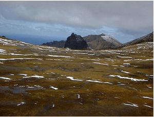 |
| Inaccessible Island | Tristan da Cunha 37°18′S 12°41′W / 37.300°S 12.683°W |
1265.24 | 20 November 2008 | An extinct volcano that is part of the archipelago of Tristan da Cunha, Inaccessible Island is an important breeding site for seabirds and endemic landbirds. | |
See also
References
This article is issued from Wikipedia - version of the 10/28/2015. The text is available under the Creative Commons Attribution/Share Alike but additional terms may apply for the media files.