List of Monuments of National Importance in Mumbai circle
This is a list of Monuments of National Importance as officially recognized by the Archaeological Survey of India (ASI) in the Indian state of Maharashtra falling under the jurisdiction of its Mumbai (ASI circle).[1]
| SL. No. | Description | Location | Address | District | Coordinates | Image |
|---|---|---|---|---|---|---|
| N-MH-M1 | Ancient site at Brahamapuri | Kolhapur | Kolhapur | |||
| N-MH-M2 | Panhala Fort
i. Ambarkhana, ii. Andhra Vav iii.Dharma Kopthi, iv. Naikinicha Sajja v. Teen Darwaja, vi. Wagh Darwaja vii. Tatabani together with bastions |
Panhala | Kolhapur | 16°48′32″N 74°06′33″E / 16.8088889°N 74.1091667°E | 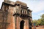
| |
| N-MH-M2-a | Panhala Fort: i. Ambarkhana | Panhala | Kolhapur | 16°48′32″N 74°06′33″E / 16.8088889°N 74.1091667°E | 
| |
| N-MH-M2-b | Panhala Fort: ii. Andhra Vav | Panhala | Kolhapur | 16°48′32″N 74°06′33″E / 16.8088889°N 74.1091667°E | ||
| N-MH-M2-c | Panhala Fort: iii.Dharma Kopthi | Panhala | Kolhapur | 16°48′32″N 74°06′33″E / 16.8088889°N 74.1091667°E | ||
| N-MH-M2-d | Panhala Fort: iv. Naikinicha Sajja | Panhala | Kolhapur | 16°48′32″N 74°06′33″E / 16.8088889°N 74.1091667°E | ||
| N-MH-M2-e | Panhala Fort: v. Teen Darwaja | Panhala | Kolhapur | 16°48′32″N 74°06′33″E / 16.8088889°N 74.1091667°E | 
| |
| N-MH-M2-f | Panhala Fort: vi. Wagh Darwaja | Panhala | Kolhapur | 16°48′32″N 74°06′33″E / 16.8088889°N 74.1091667°E | 
| |
| N-MH-M2-g | Panhala Fort: vii. Tatabani together with bastions | Panhala | Kolhapur | 16°48′32″N 74°06′33″E / 16.8088889°N 74.1091667°E | ||
| N-MH-M3 | Buddhist Caves | Panhala | Kolhapur | |||
| N-MH-M4 | Whole hill fort of Sion together with all ancient Portuguese remains of buildings situated to the north, east and south-east sides of the hill | Sion | Mumbai | 19°02′48″N 72°52′03″E / 19.046595°N 72.867498°E | 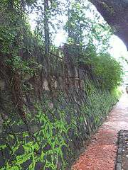
| |
| N-MH-M5 | Monolithic bass relief depicting Siva | Parel village | Mumbai | 19°00′03″N 72°50′43″E / 19.000939°N 72.845321°E | ||
| N-MH-M6 | Old Portuguese Churches, tower and caves | Mandapeshwar | Mumbai Suburban | 
| ||
| N-MH-M7 | Buddhist Caves | Kanheri | Mumbai Suburban |  More images More images
| ||
| N-MH-M8 | Jogeshwari Caves | Majas | Mumbai Suburban | 19°08′21″N 72°51′24″E / 19.1391°N 72.8568°E | 
| |
| N-MH-M9 | Kondivate Caves | Kondivate | Mumbai Suburban | 
| ||
| N-MH-M10 | Mandapeshwar Caves | Mandapeshwar | Mumbai Suburban | 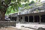
| ||
| N-MH-M11 | Portuguese Monastery over the cave & the large watch tower on the adjoining hill | Mandapeshwar | Mumbai Suburban | 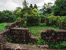
| ||
| N-MH-M12 | Songad | Achloli | Raigad | |||
| N-MH-M13 | Cathedral | Agarkot | Raigad | |||
| N-MH-M14 | Chouaburji-Castle or Factory of Cheul | Agarkot | Raigad | |||
| N-MH-M15 | Church & Convent of the Augustinians | Agarkot | Raigad | |||
| N-MH-M16 | One Dominican Church & Covent | Agarkot | Raigad | |||
| N-MH-M17 | Jusuit Monastery | Agarkot | Raigad | |||
| N-MH-M18 | Kothi | Agarkot | Raigad | 
| ||
| N-MH-M19 | Buruj | Agarkot | Raigad | 
| ||
| N-MH-M20 | St. Francis Xavier's Chapel | Agarkot | Raigad | |||
| N-MH-M21 | Satkhani St. Barbara's Tower | Agarkot | Raigad | |||
| N-MH-M22 | Two gates-Potra Da Mar & Pota da Terra | Agarkot | Raigad | |||
| N-MH-M23 | Hirakota old Fort | Agarkot | Raigad | |||
| N-MH-M24 | Kolaba Fort Containing
i) Manik Chawada, ii) Nanisahib's Palace iii) North Causeway, iv) Padmavati Shrine v) Reservoir Apsaras, vi) Sarja Kot vii) Shrine of Bhawani, viii) Shrine of Maruti ix) Shrine of Yashvantadari, xi) Talghar x) South causeway, xii) Temple of Bopdec xiii)Temple of anpati-pen-Chyaten xiv)Temple of Gulabai or Mahtshuri xv) Temple of Kanoba, xvi)Thorle wada, xvii)Temple of Mahadev xviii)Tomb of a Mahammadan saint |
Agarkot | Raigad | 18°38′04″N 72°51′51″E / 18.6344°N 72.8642°E | 
| |
| N-MH-M24-a | Kolaba Fort: i) Manik Chawada | Agarkot | Raigad | 18°38′04″N 72°51′51″E / 18.6344°N 72.8642°E | ||
| N-MH-M24-b | Kolaba Fort Containing: ii) Nanisahib's Palace | Agarkot | Raigad | 18°38′04″N 72°51′51″E / 18.6344°N 72.8642°E | ||
| N-MH-M24-c | Kolaba Fort: iii) North Causeway | Agarkot | Raigad | 18°38′04″N 72°51′51″E / 18.6344°N 72.8642°E | 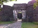
| |
| N-MH-M24-d | Kolaba Fort: iv) Padmavati Shrine | Agarkot | Raigad | 18°38′04″N 72°51′51″E / 18.6344°N 72.8642°E | ||
| N-MH-M24-e | Kolaba Fort: v) Reservoir Apsaras | Agarkot | Raigad | 18°38′04″N 72°51′51″E / 18.6344°N 72.8642°E | ||
| N-MH-M24-f | Kolaba Fort: vi) Sarja Kot | Agarkot | Raigad | 18°38′04″N 72°51′51″E / 18.6344°N 72.8642°E | 
| |
| N-MH-M24-g | Kolaba Fort: vii) Shrine of Bhawani | Agarkot | Raigad | 18°38′04″N 72°51′51″E / 18.6344°N 72.8642°E | ||
| N-MH-M24-h | Kolaba Fort: viii) Shrine of Maruti | Agarkot | Raigad | 18°38′04″N 72°51′51″E / 18.6344°N 72.8642°E | ||
| N-MH-M24-i | Kolaba Fort: ix) Shrine of Yashvantadari | Agarkot | Raigad | 18°38′04″N 72°51′51″E / 18.6344°N 72.8642°E | ||
| N-MH-M24-j | Kolaba Fort: x) South causeway | Agarkot | Raigad | 18°38′04″N 72°51′51″E / 18.6344°N 72.8642°E | 
| |
| N-MH-M24-k | Kolaba Fort: xi) Talghar | Agarkot | Raigad | 18°38′04″N 72°51′51″E / 18.6344°N 72.8642°E | ||
| N-MH-M24-l | Kolaba Fort: xii) Temple of Bopdec | Agarkot | Raigad | 18°38′04″N 72°51′51″E / 18.6344°N 72.8642°E | ||
| N-MH-M24-m | Kolaba Fort: xiii) Temple of anpati-pen-Chyaten | Agarkot | Raigad | 18°38′04″N 72°51′51″E / 18.6344°N 72.8642°E | ||
| N-MH-M24-n | Kolaba Fort: xiv)Temple of Gulabai or Mahtshuri | Agarkot | Raigad | 18°38′04″N 72°51′51″E / 18.6344°N 72.8642°E | ||
| N-MH-M24-o | Kolaba Fort: xv) Temple of Kanoba | Agarkot | Raigad | 18°38′04″N 72°51′51″E / 18.6344°N 72.8642°E | ||
| N-MH-M24-p | Kolaba Fort: xvi) Thorle wada | Agarkot | Raigad | 18°38′04″N 72°51′51″E / 18.6344°N 72.8642°E | ||
| N-MH-M24-q | Kolaba Fort: xvii) Temple of Mahadev | Agarkot | Raigad | 18°38′04″N 72°51′51″E / 18.6344°N 72.8642°E | ||
| N-MH-M24-r | Kolaba Fort: xviii) Tomb of a Mahammadan saint | Agarkot | Raigad | 18°38′04″N 72°51′51″E / 18.6344°N 72.8642°E | ||
| N-MH-M25 | Cave | Ambivli | Raigad | |||
| N-MH-M26 | Birwadi Fort | Birwadi | Raigad | |||
| N-MH-M27 | Barber's Mahel | Cheul | Raigad | |||
| N-MH-M28 | Dader (Stair Case) | Cheul | Raigad | |||
| N-MH-M29 | Kaman (Arch) | Cheul | Raigad | |||
| N-MH-M30 | Mosque | Cheul | Raigad | |||
| N-MH-M31 | Rajkot | Cheul | Raigad | |||
| N-MH-M32 | Tomb of Angre | Cheul | Raigad | |||
| N-MH-M33 | Wada of Dancing Girls | Cheul | Raigad | |||
| N-MH-M34 | Chandragad | Dhavala | Raigad | |||
| N-MH-M35 | Elephanta Caves | Gharapuri | Raigad | 18°57′30″N 72°55′50″E / 18.95833333°N 72.93055556°E |  More images More images
| |
| N-MH-M36 | Ghereagad or Surgad Fort | Ghera Surgad | Raigad | 
| ||
| N-MH-M37 | Ghosalgad Fort | Ghosale | Raigad | 
| ||
| N-MH-M38 | Old Fort containing a temple of the God Kangormel & Two tanks | Kadasari Kangori | Raigad | |||
| N-MH-M39 | Buddhist Caves | Gomashi | Raigad | |||
| N-MH-M40 | A precipitious hill near Raigad Fort Containing one rock-cut cistern of water. It was formerly used as a Jail for prisoners. | Kadasari Lingana | Raigad | |||
| N-MH-M41 | Caves | Kol | Raigad | |||
| N-MH-M42 | Caves in Survey No.49 & No. 50 | Kol | Raigad | |||
| N-MH-M43 | Kondhane Caves | Kondhane | Raigad | 
| ||
| N-MH-M44 | Old Fort | Korlai | Raigad | |||
| N-MH-M45 | Awchitgad | Medhe | Raigad | 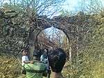
| ||
| N-MH-M46 | Caves | Kuda | Raigad | |||
| N-MH-M47 | Kasa (Kamsa) Fort also known as Murud Fort | Murud | Raigad | 
| ||
| N-MH-M48 | Thanala Caves | Nadsur | Raigad | |||
| N-MH-M49 | Nagothana Bridge | Nagothana | Raigad | |||
| N-MH-M50 | Khadsamla Caves | Nenawali | Raigad | |||
| N-MH-M51 | Jijamata's Samadhi consisting of four towers. | Pachad | Raigad | 
| ||
| N-MH-M52 | Jijamata's Wada comprising four dilapidated houses & three wells surrounded by a stone wall | Pachad | Raigad | |||
| N-MH-M53 | Caves | Pale | Raigad | |||
| N-MH-M54 | Caves Near the Kotali Fort | Peth | Raigad | 
| ||
| N-MH-M55 | Kotali Fort with two iron guns and one bronze gun | Peth | Raigad | 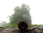
| ||
| N-MH-M56 | Janjira Fort | Rajapuri | Raigad |  More images More images
| ||
| N-MH-M57 | Tombs at Kholkar Najik Ghumaj (Khokeri Ghumaj) | Rajapuri | Raigad | 
| ||
| N-MH-M58 | Raigad Fort | Raigad | Raigad | 18°14′01″N 73°26′26″E / 18.2335°N 73.4406°E |  More images More images
| |
| N-MH-M59 | Tala Fort | Tala | Raigad | |||
| N-MH-M60 | Ancient Bricks stupa at Elephanta Island. | Gharapuri | Raigad | 18°57′36″N 72°56′06″E / 18.96°N 72.935°E | ||
| N-MH-M61 | Kondane caves | khapoli | Raigad | 
| ||
| N-MH-M62 | Aga Khan Palace Building | Pune | Pune | 18°33′08″N 73°54′05″E / 18.5523°N 73.9015°E |  More images More images
| |
| N-MH-M63 | Cave Temple of Bhamburada (known as Pataleshwar caves) | Poona | Pune | 
| ||
| N-MH-M64 | Old Citadel known as Shaniwar Wada | Poona | Pune | 18°31′09″N 73°51′20″E / 18.519075°N 73.85545°E | 
| |
| N-MH-M65 | Old European Tombs | Poona | Pune | |||
| N-MH-M66 | Fort of Rajmachi | Rajmachi | Pune | 18°50′N 73°24′E / 18.83°N 73.4°E | 
| |
| N-MH-M67 | Excavations & Inscriptions | Shelarwadi | Pune | |||
| N-MH-M68 | Visapur Fort | Visapur | Pune | 18°43′21″N 73°29′24″E / 18.7225°N 73.49°E | 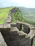 More images More images
| |
| N-MH-M69 | Small Dargah near Habsi Gumaz | Agar | Pune | |||
| N-MH-M70 | Cave Temple and Inscription (Bedse Caves) | Bedsa | Pune | 18°44′52″N 73°31′58″E / 18.74770833°N 73.53263889°E | 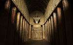
| |
| N-MH-M71 | Cave temple and Inscription | Bhaja | Pune | 
| ||
| N-MH-M72 | Caves and inscription at the Nana Pass (Naneghat) | Ghatghar | Pune | 19°18′23″N 73°40′48″E / 19.3064°N 73.6799°E | 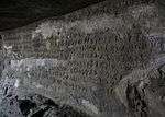
| |
| N-MH-M73 | Caves, Temple and Inscription (also known as Lenyadri) | Junnar | Pune | 19°14′34″N 73°53′08″E / 19.24277778°N 73.88555556°E | 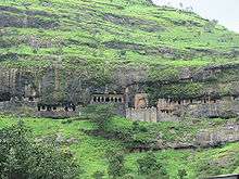 More images More images
| |
| N-MH-M74 | Shivneri Fort | Junnar | Pune |  More images More images
| ||
| N-MH-M75 | Habsi Gumbaz | Junnar | Pune | |||
| N-MH-M76 | Caves, Temple and inscription (Karla Caves) | Karla | Pune | 18°47′00″N 73°28′14″E / 18.78333333°N 73.47055556°E | 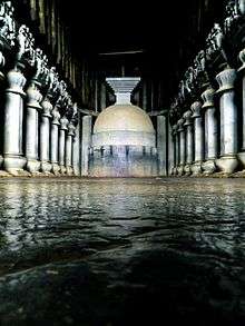
| |
| N-MH-M77 | Ancient dam with lock and sluice gates | Khed | Pune | |||
| N-MH-M78 | Dilawar Khan's Masjid | Khed | Pune | |||
| N-MH-M79 | Dilawar Khan's Tomb | Khed | Pune | |||
| N-MH-M80 | Lohagad Fort | Lohagad | Pune | 
| ||
| N-MH-M81 | Bhuleshwar Temple | Malsiras | Pune | 18°26′09″N 74°14′28″E / 18.435874°N 74.241081°E | 
| |
| N-MH-M82 | Mohammed Tughlak's Mosque | Khanapur | Sangli | |||
| N-MH-M83 | Mosque | Dabhol | Ratnagiri | |||
| N-MH-M84 | Rock cut Caves (Ganesh lena group) | Dapoli | Ratnagiri | 
| ||
| N-MH-M85 | Suvarnadurg | Harnai | Ratnagiri | 17°49′01″N 73°05′06″E / 17.817°N 73.085°E | 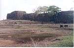
| |
| N-MH-M86 | Jaigad Fort | Jaydgad | Ratnagiri | 17°18′03″N 73°13′17″E / 17.3007°N 73.2215°E | 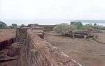
| |
| N-MH-M87 | Vijaydurg Fort | Vijaydurg | Ratnagiri | 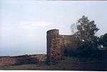
| ||
| N-MH-M88 | Panta's Kot or Got open space | Karad | Satara | 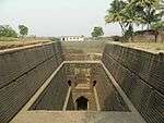
| ||
| N-MH-M89 | Old Temple of the River Krishna | Old Mahabaleshwar | Satara | 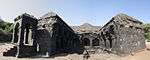
| ||
| N-MH-M90 | Jhabreshwar Mahadev Temple | Phaltan | Satara | |||
| N-MH-M91 | Buddhist caves | Jakhinwadi | Satara | |||
| N-MH-M92 | Tomb of Begami | Ghodeshwar | Sholapur | |||
| N-MH-M93 | Aurangazeb's Fort | Machnur | Sholapur | |||
| N-MH-M94 | Old Temple of Sri Siddeshwar (enclosed in a paved court) | Machnur | Sholapur | |||
| N-MH-M95 | Covered colonnade (to the south of the well) | Mahalung | Sholapur | |||
| N-MH-M96 | Hemadpanthi Temple of Mahadev | Mahalung | Sholapur | |||
| N-MH-M97 | Hemadpanthi Temple of Vithoba | Mahalung | Sholapur | |||
| N-MH-M98 | Hemadpanthi Well | Mahalung | Sholapur | |||
| N-MH-M99 | Mahadev Stones | Mahalung | Sholapur | |||
| N-MH-M100 | Temple of Devi (Yamai) | Mahalung | Sholapur | |||
| N-MH-M101 | Old Fort | Sholapur | Sholapur | | ||
| N-MH-M102 | Gateway and old Maruti temple with Viragal stones on either side. | Velapur | Sholapur | |||
| N-MH-M103 | Old doubled shrined temple | Velapur | Sholapur | |||
| N-MH-M104 | Old Temple & Viragals or sculptural memorial stones | Velapur | Sholapur | |||
| N-MH-M105 | Old Temple of Sarkarvada locally known as Parasnath temple | Velapur | Sholapur | |||
| N-MH-M106 | Temple of Haranareshwar & Ardhanarinateshwar, one Hemadpanthi tank (small square kunda) & Vinagal stone kept in the comound. | Velapur | Sholapur | |||
| N-MH-M107 | Sindhdurg fort | Malvan | Sindhdurg | 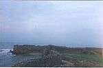
| ||
| N-MH-M108 | Temple of Ambarnath | Ambarnath | Thane |  More images More images
| ||
| N-MH-M109 | Fort | Arnala | Thane | |||
| N-MH-M110 | Fort and Portuguese remains - Bassein Fort also known as Vasai Fort | Bassein | Thane | 19°19′49″N 72°48′54″E / 19.33027778°N 72.815°E |  More images More images
| |
| N-MH-M111 | Tank by the west side of the road from Umarale village to Bolinj | Bolinj | Thane | |||
| N-MH-M112 | Mound locally known as "Sonar Bhat" | Gas | Thane | |||
| N-MH-M113 | Caves on Burud Hill | Khunwada | Thane | |||
| N-MH-M114 | Mahuli Fort | Mahuli | Thane | 
| ||
| N-MH-M115 | Mound locally known as " Burud kot" Mardes | Mardes | Thane | |||
| N-MH-M116 | Brahmanical Caves | Polu Sonala | Thane | |||
| N-MH-M117 | Carved Stones | Vada | Thane |
See also
- List of State Protected Monuments in Maharashtra
- List of Monuments of National Importance in India
- Heritage structures in Mumbai
References
External links
| Wikimedia Commons has media related to Cultural heritage monuments in Maharashtra. |