List of Midland Metro stations

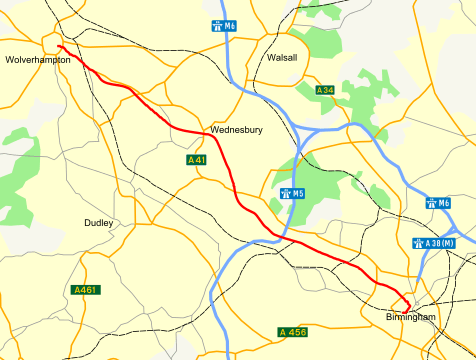
The route of Line One, shown in red

The Midland Metro is a light-rail/tram line in the West Midlands of England operating between Birmingham and Wolverhampton via West Bromwich and Wednesbury. It is owned and promoted by Centro, and operated by National Express Midland Metro,[1] a subsidiary of National Express.

It opened on 30 May 1999, mostly using the former disused Birmingham Snow Hill to Wolverhampton Low Level Line. An extension into Birmingham City Centre was approved in 2012, and is now partially operational.

Stations

Station Photo Co-ordinates
(Links to map resources)
Notes Usage
Birmingham Snow Hill 52°29′04″N 1°54′01″W / 52.48450°N 1.90032°W / 52.48450; -1.90032 Terminus. Connection with National Rail 8581
Bull Street 52°28′55″N 1°53′47″W / 52.481995°N 1.896472°W / 52.481995; -1.896472
St Paul's 52°29′14″N 1°54′17″W / 52.48716°N 1.90470°W / 52.48716; -1.90470
Jewellery Quarter 52°29′24″N 1°54′51″W / 52.48990°N 1.91421°W / 52.48990; -1.91421 Connection with National Rail
Soho Benson Road 52°29′49″N 1°55′51″W / 52.49697°N 1.93092°W / 52.49697; -1.93092
Winson Green Outer Circle 52°29′56″N 1°56′21″W / 52.49894°N 1.93927°W / 52.49894; -1.93927
Handsworth Booth Street 52°30′08″N 1°57′08″W / 52.50210°N 1.95229°W / 52.50210; -1.95229
The Hawthorns 52°30′21″N 1°57′54″W / 52.50582°N 1.96506°W / 52.50582; -1.96506 Connection with National Rail
Kenrick Park 52°30′31″N 1°58′57″W / 52.50868°N 1.98251°W / 52.50868; -1.98251
Trinity Way 52°30′43″N 1°59′18″W / 52.51187°N 1.98823°W / 52.51187; -1.98823
West Bromwich Central 52°30′59″N 1°59′41″W / 52.51652°N 1.99466°W / 52.51652; -1.99466
Lodge Road West Bromwich Town Hall 52°31′07″N 2°00′00″W / 52.51865°N 1.99987°W / 52.51865; -1.99987 439
Dartmouth Street 52°31′14″N 2°00′16″W / 52.52046°N 2.00450°W / 52.52046; -2.00450
Dudley Street Guns Village 52°31′30″N 2°00′31″W / 52.52512°N 2.00851°W / 52.52512; -2.00851
Black Lake 52°31′51″N 2°00′40″W / 52.53096°N 2.01114°W / 52.53096; -2.01114
Wednesbury Great Western Street 52°32′56″N 2°01′32″W / 52.54892°N 2.02563°W / 52.54892; -2.02563
Wednesbury Parkway 52°32′59″N 2°01′55″W / 52.54968°N 2.03202°W / 52.54968; -2.03202
Bradley Lane 52°33′22″N 2°03′28″W / 52.55603°N 2.05784°W / 52.55603; -2.05784
Loxdale 52°33′36″N 2°03′57″W / 52.56007°N 2.06589°W / 52.56007; -2.06589
Bilston Central 52°33′56″N 2°04′29″W / 52.56546°N 2.07470°W / 52.56546; -2.07470
The Crescent 52°34′05″N 2°04′51″W / 52.56795°N 2.08086°W / 52.56795; -2.08086
Priestfield 52°34′19″N 2°05′53″W / 52.57191°N 2.09798°W / 52.57191; -2.09798
The Royal 52°34′52″N 2°07′02″W / 52.58107°N 2.11711°W / 52.58107; -2.11711
Wolverhampton St George's 52°35′02″N 2°07′28″W / 52.58401°N 2.12451°W / 52.58401; -2.12451 Terminus 6167

References

  1. Home The Metro
This article is issued from Wikipedia - version of the 7/3/2016. The text is available under the Creative Commons Attribution/Share Alike but additional terms may apply for the media files.