Grade I listed buildings in Warwickshire
Warwickshire shown within England
There are over 9,000 Grade I listed buildings in England. This page is a list of these buildings in the county of Warwickshire, by district.
North Warwickshire
| Name | Location | Type | Completed [note 1] | Date designated | Grid ref.[note 2] Geo-coordinates |
Entry number [note 3] | Image |
|---|---|---|---|---|---|---|---|
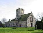
| Church of St Mary the Virgin | Astley, North Warwickshire | Church | 17th century | 8 September 1961 | SP3110389429 52°30′07″N 1°32′36″W / 52.50188°N 1.543237°W |
1184853 |  |
| Church of St Peter and St Paul | Coleshill, North Warwickshire | Church | 14th century | 8 September 1961 | SP2012089059 52°29′57″N 1°42′18″W / 52.499068°N 1.705052°W |
1034697 |  |
| Church of St James | Packington Park, Great Packington, North Warwickshire | Church | 1789 | 8 September 1961 | SP2299584074 52°27′15″N 1°39′47″W / 52.45414°N 1.663045°W |
1034813 |  |
| Church of St Peter | Mancetter, North Warwickshire | Church | 12th century | 25 March 1968 | SP3203696694 52°34′02″N 1°31′44″W / 52.567136°N 1.528795°W |
1365169 | 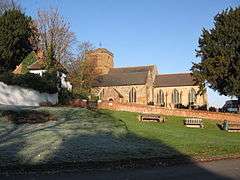 |
| Maxstoke Castle | Castle Park, Maxstoke, North Warwickshire | Castle | 1345 | 11 November 1952 | SP2241589105 52°29′58″N 1°40′16″W / 52.499392°N 1.671243°W |
1116166 |  |
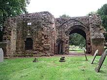
| Church of Our Lady | Merevale, North Warwickshire | Abbey | 13th and 14th centuries | 25 March 1968 | SP2904897724 52°34′36″N 1°34′22″W / 52.576562°N 1.572787°W |
1365174 |  |
| Blyth Hall | Blyth Hall, Shustoke, North Warwickshire | Country House | 1530 | 11 November 1952 | SP2094590159 52°30′32″N 1°41′34″W / 52.508925°N 1.692831°W |
1087100 |  |
Nuneaton and Bedworth
| Name | Location | Type | Completed [note 1] | Date designated | Grid ref.[note 2] Geo-coordinates |
Entry number [note 3] | Image |
|---|---|---|---|---|---|---|---|
| Arbury Hall | Arbury Park, Nuneaton and Bedworth | Country House | Late 16th century | 6 December 1947 | SP3352989275 52°30′01″N 1°30′27″W / 52.500353°N 1.507516°W |
1185222 |  |
| Stables at Arbury Hall and attached wall and gate pier to left | Arbury Park, Nuneaton and Bedworth | Stables | c. 1675 | 1 January 1956 | SP3346589328 52°30′03″N 1°30′30″W / 52.500833°N 1.508453°W |
1299708 |  |
| Church of St Nicholas | Nuneaton | Church | c. 1340 | 6 December 1947 | SP3655891653 52°31′18″N 1°27′45″W / 52.521536°N 1.462637°W |
1299514 |  |
Rugby
| Name | Location | Type | Completed [note 1] | Date designated | Grid ref.[note 2] Geo-coordinates |
Entry number [note 3] | Image |
|---|---|---|---|---|---|---|---|
| Combe Abbey and bridge over moat attached to south | Combe Abbey, Combe Fields, Rugby | Country house | Late 16th century | 6 October 1960 | SP4032779758 52°24′52″N 1°24′31″W / 52.414341°N 1.408527°W |
1233485 | 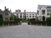 |
| Church of St Edith | Monks Kirby, Rugby | Church | 13th century | 6 October 1960 | SP4632783143 52°26′39″N 1°19′11″W / 52.444296°N 1.319851°W |
1034855 | 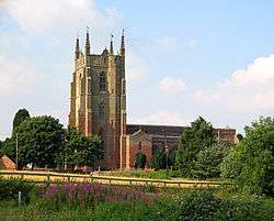 |
| Screen, Gates and Gatepiers | Newnham Paddox Park, Monks Kirby, Rugby | Gate | Early/mid 18th century | 6 October 1960 | SP4799483483 52°26′50″N 1°17′43″W / 52.447209°N 1.295279°W |
1186169 | 
|
| Church of St Margaret | Wolston, Rugby | Church | 14th century | 6 October 1960 | SP4095875755 52°22′42″N 1°23′59″W / 52.378308°N 1.399739°W |
1185682 |  |
| Bilton Hall | Bilton, Rugby | Hall House | 1623 | 11 October 1949 | SP4872273756 52°21′35″N 1°17′10″W / 52.359705°N 1.285981°W |
1035049 | 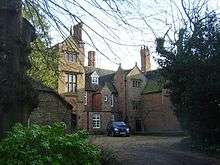 |
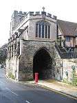
| Chapel at Rugby School | Rugby | Chapel | 1872 | 11 October 1949 | SP5021474957 52°22′13″N 1°15′50″W / 52.370367°N 1.263895°W |
1183714 | .jpg) |
| Church of St Botolph | Newbold on Avon, Rugby | Parish Church | 15th century | 11 October 1949 | SP4867477111 52°23′24″N 1°17′10″W / 52.389868°N 1.2862°W |
1183970 |  |
Stratford-on-Avon
| Name | Location | Type | Completed [note 1] | Date designated | Grid ref.[note 2] Geo-coordinates |
Entry number [note 3] | Image |
|---|---|---|---|---|---|---|---|
| Malt House | Alcester, Stratford-on-Avon | c. 1500 | 19th century | 11 December 1969 | SP0907857432 52°12′54″N 1°52′07″W / 52.21503°N 1.86855°W |
1024638 | .jpg) |
| Town Hall | Alcester, Stratford-on-Avon | Town hall | c. 1618 | 10 February 1956 | SP0908257521 52°12′57″N 1°52′07″W / 52.21583°N 1.868489°W |
1024606 |  |
| Ragley Hall | Arrow with Weethley, Stratford-on-Avon | Country House | 1680-83 | 1 February 1967 | SP0719755538 52°11′53″N 1°53′46″W / 52.19803°N 1.89612°W |
1355348 | 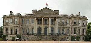 |
| Church of St John the Baptist | Aston Cantlow, Stratford-on-Avon | Church | Late 13th century | 1 February 1967 | SP1376559868 52°14′13″N 1°47′59″W / 52.236834°N 1.799851°W |
1024581 |  |
| Church of St Nicholas | Beaudesert, Stratford-on-Avon | Church | Mid 12th century | 5 April 1967 | SP1529566041 52°17′32″N 1°46′38″W / 52.292291°N 1.777169°W |
1382266 | 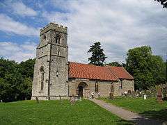 |
| Bidford Bridge | Bidford-on-Avon, Stratford-on-Avon | Bridge | Early 15th century | 1 February 1967 | SP0990451761 52°09′51″N 1°51′24″W / 52.164032°N 1.856624°W |
1355318 |  |
| Church of All Saints | Billesley, Stratford-on-Avon | Church | 12th century | 5 April 1967 | SP1476256816 52°12′34″N 1°47′07″W / 52.20937°N 1.785384°W |
1382704 | 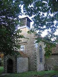 |
| Church of St George | Lower Brailes, Brailes, Stratford-on-Avon | Church | 13th century | 13 October 1966 | SP3153239303 52°03′04″N 1°32′30″W / 52.051224°N 1.541588°W |
1024382 |  |
| Church of All Saints | Burton Dassett, Stratford-on-Avon | Church | 12th century | 30 May 1967 | SP3984851441 52°09′35″N 1°25′08″W / 52.159812°N 1.418908°W |
1035653 | 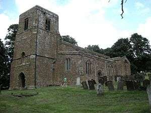 |
| Charlecote Park | Charlecote, Stratford-on-Avon | Country House | 1558 | 6 February 1952 | SP2590656425 52°12′20″N 1°37′20″W / 52.205446°N 1.62233°W |
1381799 | 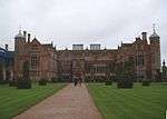 |
| Church of St Leonard | Charlecote, Charlecote, Stratford-on-Avon | Church | 1851-3 | 5 April 1967 | SP2624956552 52°12′24″N 1°37′02″W / 52.206572°N 1.617301°W |
1381830 |  |
| Gatehouse to Charlecote Park | Charlecote, Stratford-on-Avon | Gatehouse | c. 1560 | 5 April 1967 | SP2599356411 52°12′19″N 1°37′16″W / 52.205316°N 1.621058°W |
1381800 | .jpg) |
| Laundry and brewhouse and stables and coach house immediately south of Charlecote Park | Charlecote, Stratford-on-Avon | Estate Laundry | 16th century | 5 April 1967 | SP2596256368 52°12′18″N 1°37′17″W / 52.204931°N 1.621515°W |
1381808 |
|
| Church of St John the Baptist | Cherington, Stratford-on-Avon | Church | 13th century | 13 October 1966 | SP2916836585 52°01′37″N 1°34′35″W / 52.026917°N 1.576292°W |
1355498 | 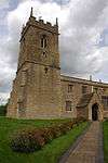 |
| Chesterton Windmill | Chesterton and Kingston, Stratford-on-Avon | Windmill | 1632 | 7 January 1952 | SP3486459349 52°13′52″N 1°29′27″W / 52.231241°N 1.490951°W |
1300056 |  |
| Compton Verney House and attached screen wall | Compton Verney, Stratford-on-Avon | Country House | c. 1714 | 6 February 1952 | SP3106552830 52°10′22″N 1°32′50″W / 52.172861°N 1.547168°W |
1381862 | .jpg) |
| Chapel immediately north-west of Compton Verney House | Compton Verney, Stratford-on-Avon | Chapel | 1772 | 6 February 1952 | SP3101652875 52°10′24″N 1°32′52″W / 52.173269°N 1.547881°W |
1381863 |
|
| Compton Wynyates | Compton Wynyates, Stratford-on-Avon | House | c. 1500 | 2 September 1952 | SP3306141829 52°04′26″N 1°31′09″W / 52.073845°N 1.519048°W |
1024349 |  |
| Parish Church (dedication unknown) | Compton Wynyates, Stratford-on-Avon | Church | c. 1665 | 22 September 1981 | SP3300841926 52°04′29″N 1°31′11″W / 52.07472°N 1.519812°W |
1024351 |
|
| Church of St Peter | Coughton, Stratford-on-Avon | Church | c. 1530 | 1 February 1967 | SP0834560561 52°14′35″N 1°52′45″W / 52.243172°N 1.879202°W |
1024600 | .JPG) |
| Coughton Court | Coughton, Stratford-on-Avon | Country House | Early 16th century | 10 February 1956 | SP0829960605 52°14′37″N 1°52′48″W / 52.243569°N 1.879875°W |
1183632 | 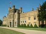 |
| Ettington Park Hotel | Alderminster, Ettington, Stratford-on-Avon | Country House | Mid 17th century | 5 April 1967 | SP2474247314 52°07′25″N 1°38′24″W / 52.123589°N 1.640024°W |
1382586 |  |
| Former Church of Holy Trinity Approximately 70 Metres East of Ettington Park Hotel | Ettington, Stratford-on-Avon | Church | c1200 additions | 5 April 1967 | SP2481147310 52°07′25″N 1°38′20″W / 52.12355°N 1.639017°W |
1382588 |  |
| Farnborough Hall | Farnborough, Stratford-on-Avon | Country House | Late 17th century | 7 January 1952 | SP4307349413 52°08′29″N 1°22′19″W / 52.141339°N 1.372023°W |
1374964 | 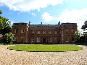 |
| Church of St Peter ad Vincula | Hampton Lucy, Stratford-on-Avon | Church | 1822-6 | 5 April 1967 | SP2564757013 52°12′39″N 1°37′34″W / 52.210745°N 1.626076°W |
1382119 |  |
| Church of St John the Baptist Including Wall to Guildhall | Henley-in-Arden, Stratford-on-Avon | Church | c. 1450 | 5 April 1967 | SP1511266015 52°17′31″N 1°46′47″W / 52.292062°N 1.779854°W |
1382379 |  |
| Church of All Saints | Honington, Stratford-on-Avon | Church | c1275-1300 | 13 October 1966 | SP2613542667 52°04′54″N 1°37′12″W / 52.081747°N 1.620033°W |
1355483 | 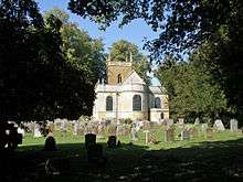 |
| Honington Hall and attached gateways, walls and temple | Honington, Stratford-on-Avon | Country House | c. 1685 | 2 September 1952 | SP2608442687 52°04′55″N 1°37′15″W / 52.08193°N 1.620775°W |
1024327 | 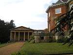 |
| Church of St Mary | Ilmington, Stratford-on-Avon | Church | Mid 12th century | 13 October 1966 | SP2096143470 52°05′21″N 1°41′44″W / 52.089186°N 1.695485°W |
1024126 |  |
| Church of St Mary the Virgin dovecote approximately 105 metres north east | Kinwarton, Stratford-on-Avon | Dovecote | Early/mid 14th century | 1 February 1967 | SP1058958459 52°13′27″N 1°50′47″W / 52.224237°N 1.846403°W |
1365691 |  |
| Church of All Saints | Ladbroke, Stratford-on-Avon | Church | 1616 | 30 May 1967 | SP4134658896 52°13′36″N 1°23′46″W / 52.226722°N 1.396104°W |
1035567 |  |
| Church of St Peter and St Paul | Long Compton, Stratford-on-Avon | Church | Early 13th century | 13 October 1966 | SP2874733033 51°59′42″N 1°34′58″W / 51.995005°N 1.582724°W |
1355491 | 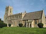 |
| Church of St James | Long Marston, Stratford-on-Avon | Church | 16th century | 5 April 1967 | SP1527548120 52°07′52″N 1°46′42″W / 52.131176°N 1.778265°W |
1382595 |  |
| Church of St Nicholas | Loxley, Stratford-on-Avon | Church | 1845 | 5 April 1967 | SP2585653052 52°10′30″N 1°37′24″W / 52.175125°N 1.623318°W |
1382620 |  |
| Church of St Lawrence | Oxhill, Stratford-on-Avon | Church | 12th century | 13 October 1966 | SP3169145514 52°06′25″N 1°32′19″W / 52.107054°N 1.538694°W |
1364748 | .jpg) |
| Alscot Park | Alscot Park, Preston on Stour, Stratford-on-Avon | Country House | 17th century | 6 February 1952 | SP2080550471 52°09′08″N 1°41′50″W / 52.152133°N 1.697336°W |
1382655 |  |
| Church of St Mary | Preston on Stour, Stratford-on-Avon | Church | 15th century | 5 April 1967 | SP2033749935 52°08′50″N 1°42′15″W / 52.147332°N 1.704208°W |
1382639 |  |
| Church of St Swithin | Quinton, Stratford-on-Avon | Church | 12th century | 5 April 1967 | SP1835147029 52°07′17″N 1°44′00″W / 52.121275°N 1.733387°W |
1382665 |  |
| Church of St Matthew | Salford Priors, Stratford-on-Avon | Church | 12th century | 1 February 1967 | SP0773250997 52°09′26″N 1°53′18″W / 52.157197°N 1.888395°W |
1355366 |  |
| Salford Hall | Abbots Salford, Salford Priors, Stratford-on-Avon | Country House | Late 15th century | 1 February 1967 | SP0677350060 52°08′56″N 1°54′09″W / 52.148786°N 1.902431°W |
1300427 |  |
| Church of St James the Great | Snitterfield, Stratford-on-Avon | Church | c. 1300 | 5 April 1967 | SP2184460095 52°14′19″N 1°40′54″W / 52.238616°N 1.681534°W |
1382171 |  |
| Church of St James | Southam, Stratford-on-Avon | Church | 14th century | 30 May 1967 | SP4179261768 52°15′09″N 1°23′21″W / 52.252507°N 1.38922°W |
1185823 | 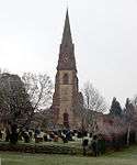 |
| Anne Hathaway's Cottage | Shottery, Stratford-upon-Avon | Farmhouse | 16th century | 25 October 1951 | SP1844954745 52°11′26″N 1°43′54″W / 52.190641°N 1.73154°W |
1298551 | .jpg) |
| Church of Holy Trinity | Stratford-upon-Avon | Church | Early 13th century | 25 October 1951 | SP2010154284 52°11′11″N 1°42′27″W / 52.186439°N 1.707401°W |
1187824 | 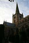 |
| Clopton Bridge and attached Former Toll House | Stratford-upon-Avon | Toll House | 1814 | 25 October 1951 | SP2058654852 52°11′30″N 1°42′01″W / 52.191528°N 1.700273°W |
1204167 | 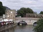 |
| Guild Chapel of the Holy Cross | Stratford-upon-Avon | Guild Chapel | 13th century | 25 October 1951 | SP2007554738 52°11′26″N 1°42′28″W / 52.190522°N 1.707755°W |
1204554 | 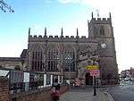 |
| Guildhall, King Edward VI Grammar School | Stratford-upon-Avon, Stratford-on-Avon | Guildhall | c. 1417 | 25 October 1951 | SP2005554723 52°11′25″N 1°42′29″W / 52.190388°N 1.708048°W |
1187780 | 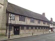 |
| Hall's Croft and attached Garden Wall | Stratford-upon-Avon | Timber Framed House | Early 16th century | 25 October 1951 | SP2001454525 52°11′19″N 1°42′31″W / 52.188609°N 1.708659°W |
1187827 | 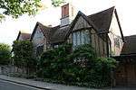 |
| Harvard House | Stratford-upon-Avon | House | After 1595 | 25 October 1951 | SP2011354880 52°11′30″N 1°42′26″W / 52.191797°N 1.70719°W |
1298524 |  |
| Nash's House (new Place Museum) | Stratford-upon-Avon | Timber Framed House | c. 1600 | 25 October 1951 | SP2009254771 52°11′27″N 1°42′27″W / 52.190818°N 1.707504°W |
1204376 |  |
| Shakespeare's Birthplace | Stratford-upon-Avon | Timber Framed House | Late 15th century | 25 October 1951 | SP2005555113 52°11′38″N 1°42′29″W / 52.193894°N 1.708025°W |
1187807 |  |
| The Almshouses | Stratford-upon-Avon | Almshouse | Built 1427-1428 | 25 October 1951 | 49°46′01″N 7°33′26″W / 49.766806°N 7.55716°W | 1298549 |  |
| The Pedagogue's House, King Edward VI Grammar School | Stratford-upon-Avon | Teachers House | c. 1553 | 25 October 1951 | SP2007154714 52°11′25″N 1°42′28″W / 52.190306°N 1.707814°W |
1298548 |  |
| Church of St Mary Magdalene | Tanworth-in-Arden, Stratford-on-Avon | Church | 1330-1340 | 5 April 1967 | SP1134870513 52°19′57″N 1°50′06″W / 52.33259°N 1.83489°W |
1382445 | 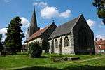 |
| Church of St Gregory | Tredington, Stratford-on-Avon | Church | c1000 Anglo-Danish | 13 October 1966 | SP2591743569 52°05′24″N 1°37′23″W / 52.089867°N 1.623146°W |
1024028 |  |
| Church of the Assumption of the Blessed Virgin Mary | Middle Tysoe, Tysoe, Stratford-on-Avon | Church | Late 11th century | 13 October 1966 | SP3409644369 52°05′48″N 1°30′13″W / 52.096617°N 1.503695°W |
1186160 | .jpg) |
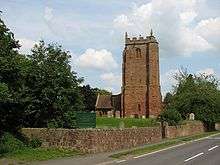
| Church of St Michael | Warmington, Stratford-on-Avon | Church | 12th century | 30 May 1967 | SP4097647483 52°07′27″N 1°24′10″W / 52.124147°N 1.402895°W |
1355583 |  |
| Church of St Peter | Welford-on-Avon, Stratford-on-Avon | Church | Early 13th century middle stage | 5 April 1967 | SP1458152223 52°10′05″N 1°47′18″W / 52.168083°N 1.788229°W |
1382823 |  |
| Church of All Saints | Weston-on-Avon, Stratford-on-Avon | Church | Late 15th century | 5 April 1967 | SP1586851917 52°09′55″N 1°46′10″W / 52.165296°N 1.769426°W |
1382865 | 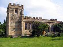 |
| Church of St Michael | Whichford, Stratford-on-Avon | Church | 15th century | 13 October 1966 | SP3120534659 52°00′34″N 1°32′48″W / 52.009491°N 1.546778°W |
1355543 | 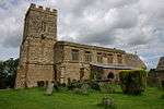 |
| Dovecote Approximately 4 Metres East of Palmers Farmhouse | Wilmcote, Wilmcote, Stratford-on-Avon | Dovecote | Pre-C16 | 1 February 1967 | SP1644458141 52°13′16″N 1°45′39″W / 52.221235°N 1.760705°W |
1024558 |  |
| Mary Arden's House and Attached Dairy | Wilmcote, Wilmcote, Stratford-on-Avon | Farmhouse | 16th century | 11 December 1969 | SP1637658090 52°13′15″N 1°45′42″W / 52.220779°N 1.761703°W |
1024575 |  |
| Palmers Farmhouse | Wilmcote, Wilmcote, Stratford-on-Avon | Farmhouse | Late 16th century | 1 February 1967 | SP1643358134 52°13′16″N 1°45′39″W / 52.221173°N 1.760867°W |
1184729 | 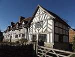 |
| Church of St Peter | Wootton Wawen, Stratford-on-Avon | Church | 1035-1040 | 5 April 1967 | SP1531063276 52°16′03″N 1°46′37″W / 52.267433°N 1.777074°W |
1382227 | .jpg) |
| Church of St Peter | Wormleighton Stratford-on-Avon | Church | Early 12th century | 30 May 1967 | SP4477053914 52°10′54″N 1°20′48″W / 52.181667°N 1.346636°W |
1299347 |  |
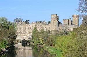
Warwick

.jpg)
_-_geograph.org.uk_-_481242.jpg)


.jpg)


See also
Notes
- 1 2 3 4 5 The date given is the date used by Historic England as significant for the initial building or that of an important part in the structure's description.
- 1 2 3 4 5 Sometimes known as OSGB36, the grid reference is based on the British national grid reference system used by the Ordnance Survey.
- 1 2 3 4 5 The "List Entry Number" is a unique number assigned to each listed building and scheduled monument by Historic England.
References
English Heritage Images of England
External links
![]() Media related to Grade I listed buildings in Warwickshire at Wikimedia Commons
Media related to Grade I listed buildings in Warwickshire at Wikimedia Commons
This article is issued from Wikipedia - version of the 12/2/2016. The text is available under the Creative Commons Attribution/Share Alike but additional terms may apply for the media files.