List of Grade I listed buildings in Salisbury
There are 36 buildings and constructions listed as Grade I by English Heritage in the City of Salisbury. The list on this page is ordered in the following way, buildings within the Cathedral Close and the others with respect to their original function.
- 21 buildings in the Cathedral Close.
- 3 churches.
- 2 residences.
- 2 inns.
- 5 buildings that had an institutional or community use when constructed.
- 2 river bridges.
- an ancient ruin.
| Name | Place | Map ref | Date | Notes | Image |
|---|---|---|---|---|---|
| Cathedral Church of St. Mary | North Walk, The Close, Salisbury | 51°03′54″N 1°47′51″W / 51.064944°N 1.79738°W | 1220 | Foundations laid April 25, 1220. Consecrated 1225, 1258 and when completed in 1266. |  |
| Salisbury Cathedral School | The Close, Salisbury. SP1 2EQ | 51°03′50″N 1°47′46″W / 51.063886°N 1.796082°W | 13/15th century | Initially residential, now a private school. | 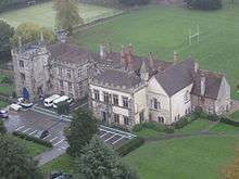 |
| Malmesbury House | North Walk, The Close, Salisbury | 51°03′58″N 1°47′38″W / 51.066054°N 1.793979°W | 1416 | Original known as Copt Hall demolished in 1399, still residential. | 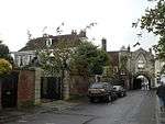 |
| The Theological College | North Walk, The Close, Salisbury. SP1 2EG | 51°03′58″N 1°47′43″W / 51.0662°N 1.7954°W | Late 17th century | Now called Sarum College, an ecumenical study centre. |  |
| The Close Wall, Rosemary Lane | Rosemary Lane, North Walk, The Close, Salisbury, also Exeter St. Salisbury | 51°03′54″N 1°47′38″W / 51.0650°N 1.7939°W | 1331 | The ancient wall surrounding the Cathedral close on north, east and south sides. Remnants of Old Sarum Cathedral visible. | no image |
| The Matron's College | 39-46 The High Street, Salisbury. SP1 2EL | 51°04′00″N 1°47′52″W / 51.066659°N 1.797729°W | 1682 | Accommodation for clergy widows. Established by Bishop Seth Ward and probably designed by Christopher Wren, still functions with original intent. |  |
| North Gate | High St. Salisbury. SP1 2EG | 51°04′01″N 1°47′52″W / 51.066957°N 1.797729°W | 14/15th century | Two-storey building over and around north entrance to the Cathedral Close. | .jpg) |
| Mompesson House | Choristers' Green, The Close Salisbury. SP1 2EG | 51°40′01″N 1°47′55″W / 51.66687°N 1.798486°W | 1704 | Town house built for Sir Thomas Mompesson, 17/18th century MP, now a historical exhibit. |  |
| Screen, Walls, Piers, Gates and Overthrow of Mompesson House | Choristers' Green, The Close Salisbury. SP1 2EG | 51°40′01″N 1°47′55″W / 51.66687°N 1.798486°W | 1704 | Frontage of house, low wall, iron gate and railings,18th century iron lamps. |  |
| Wren Hall | Choristers' Green, The Close, Salisbury. SP1 2EL | 51°04′00″N 1°47′57″W / 51.0666°N 1.7993°W | 14/15th century wing of Braybrook House rebuilt in 1714 | Originally a cathedral choristers' school, now used as a cathedral education centre. |  |
| Braybrooke House | Choristers' Green, The Close. SP1 2EG | 51°03′59″N 1°47′59″W / 51.0664°N 1.7996°W | 14/15th century | Initially residential, now a resource centre. | .jpg) |
| Hemingsby House | Choristers' Green, The Close, Salisbury. SP1 2EL | 51°04′00″N 1°47′57″W / 51.066754°N 1.799119°W | 14/15th century | Former canonry, has appearance of two houses. | .jpg) |
| The King's House | West Walk, The Close, Salisbury. SP1 2EG | 51°03′52″N 1°48′00″W / 51.064547°N 1.800004°W | 13/14th century, altered in 16/17th century | Originally the residence of the Abbot of Sherborne, now a museum. |  |- |- |
| 68 West Walk | The Close, Salisbury. SP1 2EN | 51°03′50″N 1°48′00″W / 51.0639°N 1.7999°W | 1594 | Residential to the present day[12] |  |
| Retaining Wall, Screen Railing, Piers and Gates of No. 68 West Walk | 68 West Walk, The Close, Salisbury. SP1 2EN | 51°03′50″N 1°47′59″W / 51.0638°N 1.7996°W | circa 1720 | Iron decorative screen with gate and low wall. | no image |
| The Walton Canonry | No. 96 West Walk, The Close, Salisbury. SP1 2EN | 51°03′47″N 1°47′58″W / 51.062989°N 1.799505°W | 1720 | A private residence, named from earlier resident, Canon Walton, son of the angler, still residential. | 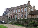 |
| Leaden Hall | West Walk, The Close, Salisbury. SP1 2EP | 51°03′47″N 1°48′00″E / 51.06305°N 1.79987°E | 1717 | Original site of canonical house of Elias of Dereham, now part of a private school. | no image |
| South Gate or Harnham Gate and Gatehouse | 1 de Vaux Place, Salisbury. SP1 2ES | 51°03′45″N 1°47′52″W / 51.062364°N 1.797729°W | 14th Century | Archway, gate and gatehouse. Southern gate into Cathedral Close. |  |
| Bishop's Gate | Exeter Street, Salisbury. SP1 2EG | 51°03′51″N 1°47′39″W / 51.064054°N 1.79415°W | 13/14th century | The eastern gateway into Cathedral Close | no image |
| St Annes Gate | 2 St John's St, Salisbury. SP1 2EG | 51°03′57″N 1°47′37″W / 51.065895°N 1.79368°W | circa 1331 | Originally a residence and gateway, now only partly residential but still a gateway. |  |
| Church of St. Lawrence | Stratford-sub-Castle, Salisbury | 51°05′34″N 1°48′55″W / 51.092782°N 1.815276°W | Early C13 chancel but consecration recorded for 1326. | Parish Church of the village of Stratford sub Castle |  |
| Church of St Martin | St Martin's Church St., Salisbury. SP1 2HY | 51°03′56″N 1°47′14″W / 51.065548°N 1.787188°W | 13/14th century | Originally a Saxon church, several restorations. |  |
| Church of St Thomas and St Edmund | St Thomas' Square., Salisbury. SP1 1BA | 51°04′08″N 1°47′50″W / 51.068986°N 1.797134°W | Probably 1220 | Parish church of New Sarum. | 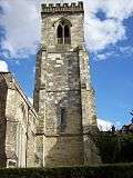 |
| John Halle's Hall | The New Canal, Salisbury. SP1 2AD | 51°05′13″N 1°47′42″W / 51.086845°N 1.794902°W | 15th century with late 19th century frontage. | Originally residential, now entrance to Odeon cinema. | no image |
| 91 Crane Street | Salisbury SP1 2PU. | 51°04′03″N 1°47′54″W / 51.067415°N 1.79822°W | mid 14th century | Residential.
Previously called 'Le Crane' in 1455 [22] |
 |
| The King's Arms | St John's Street, Salisbury. SP1 2SB | 51°03′58″N 1°47′24″W / 51.066134°N 1.79012°W | 15th century | Probably residential initially, later and now, an inn. |  |
| The Old George Inn | 15-17 The High Street, Salisbury. SP1 2NT | 51°04′04″N 1°47′51″E / 51.067839°N 1.797405°E | 14th century | This old inn has a number of literary and historical connections, now, with ground floor removed, entrance to shopping mall. No longer an inn. | .jpg) |
| Church House | 99/101 Crane St, Salisbury. SP1 2QE | 51°04′03″N 1°47′57″W / 51.067378°N 1.799258°W | 15/18th century | Originally donated by the Audley family as a workhouse, now diocesan administrative offices. |  |
| Joiners' Hall | St Ann's Street, Salisbury. SP1 2DX | 51°03′58″N 1°47′24″W / 51.066188°N 1.79012°W | Early 17th century | Initially a guild meeting hall, now residential |  |
| Mill House and Old Mill | Town Path, Harnham, Salisbury | 51°03′50″N 1°48′30″W / 51.063839°N 1.808217°W | 14/15th century | Mill house, restored early 19th century, now with hotel attached. |  |
| School of Arts Annexe | 4 New Street, Salisbury. SP1 2PH | 51°04′02″N 1°47′40″E / 51.067093°N 1.794379°E | 18th century | Originally part of Salisbury School of Art, now offices. |  |
| The Poultry Cross | Silver Street/Minster Street, Salisbury. SP1 2NG | 51°04′08″N 1°47′46″E / 51.068759°N 1.79616°E | 14th century | Originally to mark the site of a market. Still used as a market site twice weekly. | 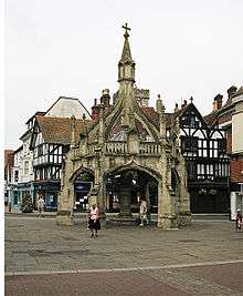 |
| Trinity Street Almshouses | Nos. 1-13 Trinity Street Salisbury. SP1 2BD | 51°04′01″N 1°47′31″W / 51.066881°N 1.79185°W | 1379 | 2 storied medieval hospital and accommodation rebuilt in 1702, now accommodation for elderly people. | 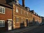 |
| Crane Bridge | Cranebridge Road, Salisbury. SP1 2QE | 51°04′04″N 1°47′50″W / 51.067721°N 1.797134°W | 15th century | 4-span bridge over River Avon. |  |
| Harnham Bridge or Ayleswade Bridge | St Nicholas Road, Salisbury. SP1 2SN | 51°03′38″N 1°47′47″W / 51.060616°N 1.796501°W | 1244 | The oldest bridge in Salisbury. Built by Bishop Bingham over the River Avon | 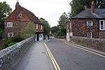 |
| Remains of Old Sarum Castle and Cathedral | Castle Road, Salisbury. SP1 3YS | 51°05′34″N 1°48′17″W / 51.092904°N 1.804762°W | 12th century | Originally an important town and citadel, now a historical site. |  |
References
- ↑ "Cathedral School". British Listed Buildings. Retrieved 19 May 2013.
- ↑ "Leaden Hall". British Listed Buildings. Retrieved 19 May 2013.
- ↑ "The Theological College". British Listed Buildings. Retrieved 19 May 2013.
- ↑ "The Close Wall". British Listed Buildings. Retrieved 19 May 2013.
- ↑ "The Matrons' College". British Listed Buildings. Retrieved 19 May 2013.
- ↑ "North Gate". British Listed Buildings. Retrieved 19 May 2013.
- ↑ "Frontage of Mompesson House". British Listed Buildings. Retrieved 19 May 2013.
- ↑ "Wren Hall". British Listed Buildings. Retrieved 19 May 2013.
- ↑ "Braybrooke House". British Listed Buildings. Retrieved 19 May 2013.
- ↑ "Hemingsby House". British Listed Buildings. Retrieved 19 May 2013.
- ↑ "The King's House". British Listed Buildings. Retrieved 19 May 2013.
- ↑ "68 The Close". British Listed Buildings. Retrieved 19 May 2013.
- ↑ "Retaining wall etc. 68 The Close". British Listed Buildings. Retrieved 19 May 2013.
- ↑ "The Walton Canonry". British Listed Buildings.
- ↑ "Leaden Hall". British Listed Buildings. Retrieved 19 May 2013.
- ↑ "Harnham Gate". British Listed Buildings. Retrieved 19 May 2013.
- ↑ "Bishop's Gate". British Listed Buildings. Retrieved 19 May 2013.
- ↑ "St Annes Gate". British Listed Buildings. Retrieved 19 May 2013.
- ↑ "Church of St. Martin". British Listed Buildings. Retrieved 19 May 2013.
- ↑ "Church of St. Thomas". British Listed Buildings. Retrieved 19 May 2013.
- ↑ "The Hall of John Halle". British Listed Buildings. Retrieved 19 May 2013.
- ↑ "91 Crane St.". British Listed Buildings. Retrieved 19 May 2013.
- ↑ "The Kings Arms". British Listed Buildings. Retrieved 19 May 2013.
- ↑ "The Old George Inn". British Listed Buildings. Retrieved 19 May 2013.
- ↑ "Church House". British Listed Buildings. Retrieved 19 May 2013.
- ↑ "Joiners Hall". British Listed Buildings. Retrieved 19 May 2013.
- ↑ "Leaden Hall". British Listed Buildings. Retrieved 19 May 2013.
- ↑ "School of Arts Annexe". British Listed Buildings. Retrieved 19 May 2013.
- ↑ "The Poultry Cross". British Listed Buildings. Retrieved 19 May 2013.
- ↑ "The Poultry Cross". British Listed Buildings. Retrieved 19 May 2013.
- ↑ "Crane Bridge". British Listed Buildings. Retrieved 19 May 2013.
- ↑ "Ayleswade Bridge". British Listed Buildings. Retrieved 19 May 2013.
This article is issued from Wikipedia - version of the 5/17/2016. The text is available under the Creative Commons Attribution/Share Alike but additional terms may apply for the media files.