List of Birmingham board schools
This is a list of the Birmingham board schools, built between the Elementary Education Act 1870 which established board schools, and the Education Act 1902, which replaced school boards with Local Education Authorities. Most of the board schools were designed by the firm Martin & Chamberlain (M&C).
List of board schools
From these sources:[1][2][3][4][5][6][7]
| Name | Picture | Address, Notes | Architect | Grid reference | Coordinates (links to map & photo sources) | Grade | Images of England or other link |
|---|---|---|---|---|---|---|---|
| Name | Picture | Memorial Stone: "The first state school built in Birmingham stood on this site Bloomsbury 1873 - 1968" | 1873–1968 | SP0888788356 | 52.493046, -1.870536 | ||
| Allcock St School | †Demolished. Other names: Deritend or Bordesley, now listed as The Bridge Centre and Community Industry. | 1875–80 M&C [2] | SP081864 | 52°28′31″N 1°52′48″W / 52.4754°N 1.8800°W | Grade II listed | Historic England. "The Bridge Centre (216727)". Images of England., Historic England. "Community Industry (216728)". Images of England. | |
| Bristol Street Board School | †Demolished 1960s for widening of the Horsefair road. At junction of Irving Street and Bristol Street. Was used as a meeting place for the Christian Society from 1877 until 1892. | [5][6] | SP068861 | 52°28′23″N 1°54′00″W / 52.4731°N 1.9001°W[7] | Picture of school before demolition from Birmingham Images | ||
| Icknield Street School | 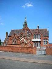 |
near the Hockley Flyover, north of the Jewellery Quarter. | 1883 M&C [1] | SP057882 | 52°29′38″N 1°54′57″W / 52.4940°N 1.9158°W | Grade II* listed | Historic England. "School (217324)". Images of England., Historic England. "Master's house (217323)". Images of England. |
| Stratford Road Primary School |  |
Now Ladypool Junior & Infant School, Sparkbrook. First M&C school built after Chamberlain's death.[5] The school was extensively damaged in the Birmingham Tornado on 28 July 2005 and lost its distinctive Martin & Chamberlain tower. For damage see and . | 1885 M&C [1][2] | SP086848 | 52°27′41″N 1°52′27″W / 52.4613°N 1.8741°W | Grade II* listed | Historic England. "Details from image database (217657)". Images of England. |
| Harborne School |  |
106 High Street, now the Clock Tower Community Education Centre. Built by Harborne School Board (Staffordshire) and acquired by the expansion of Birmingham.[8] | 1885, M&C [2] or 1881 J. P. Sharp & Co[9] | SP035845 | 52°27′34″N 1°56′48″W / 52.4594°N 1.9466°W | Grade II listed | Historic England. "Details from image database (217294)". Images of England. = Historic England. "Clock Harborne (Grade II) (1343074)". National Heritage List for England. Retrieved 11 February 2013. |
| Oozells Street Board School |  |
Listed as Furniture Stores of City of Birmingham Education Department; College of Food and Domestic Arts; now the Ikon Gallery. | 1878 M&C [1][5] | SP060866 | 52°28′40″N 1°54′45″W / 52.4777°N 1.9124°W | Grade II listed | Historic England. "Details from image database (217477)". Images of England. |
| Floodgate School |  |
Floodgate Street and Milk Street, Deritend, now South Birmingham College Arts and Media Campus, formerly Hall Green College annexe. | 1890 [2][10] | SP078864 | 52°28′32″N 1°53′09″W / 52.4756°N 1.8859°W | Grade II listed | Historic England. "Details from image database (217398)". Images of England. |
| Waverley Road |  |
Waverley Road, Byron Road, also known as County Grammar School, Small Heath; Hall Green Technical College;[5] Small Heath School | 1880–85 or 1892 M&C [1][2] | SP097852 | 52°27′53″N 1°51′28″W / 52.4647°N 1.8577°W | Grade II* listed | Historic England. "School (217752)". Images of England., Historic England. "Headmaster's house (216831)". Images of England. |
| Somerville Road |  |
omerville School, Somerville Road, Small Heath, B10 9EN (modernised). | 1892-4 M&C [11] | SP099859 | 52°28′15″N 1°51′19″W / 52.4709°N 1.8553°W | ||
| Tilton Girls School |  |
Tilton Road, B9. Now Darul Barakaat Mosque and Community Centre. | 1890 [3] | SP092866 | 52°28′37″N 1°51′54″W / 52.4769°N 1.8651°W | Grade II listed | Historic England. "Details from image database (217673)". Images of England. |
| Dixon Road County Primary School |  |
Dixon Road, Small Heath, B10 0BP. Also fronts Cooksey Road. Was Newlands Centre and Regents Park Annexe & 48 Cooksey Road, Bordesley. Also BCC furniture recycling and Birmingham Community Transport. Now Shah Poran Islamic Jami Mosque And Community Trust. | 1880–90 [1][3] | SP088857 | 52°28′12″N 1°52′11″W / 52.4701°N 1.8698°W | Grade II listed | Historic England. "Newlands Centre (217002)". Images of England., Historic England. "Regent's Park Annex (217003)". Images of England. |
| Garrison Lane Nursery School | 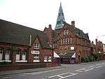 |
Garrison Lane, Bordesley, B3 4BS. Now Kownayn Primary School and Garrison Lane Centre. | c1885 M&C [3] | SP086869 | 52°28′49″N 1°52′24″W / 52.4804°N 1.8733°W | Grade II listed | Historic England. "School (217092)". Images of England., Historic England. "Headmaster's house, No 106 (217093)". Images of England. |
| Dudley Road School |  |
Now Summerfield Centre; was Summerfield Junior and Infants School, Dudley Road, Winson Green; listed as Main Block to Handsworth Technical College | 1878 M&C [5] | SP042876 | 52°29′13″N 1°56′19″W / 52.4869°N 1.9385°W | Grade II listed | Historic England. "Details from image database (217025)". Images of England. |
| Barford Road School |  |
Now Barford Road Primary School, Barford Road, Winson Green | 1887 M&C [5] | SP044873 | 52°29′04″N 1°56′06″W / 52.4845°N 1.9351°W | ||
| Hutton Street, renamed to Eliot Street |  |
Opened for over 1000 pupuils[12] Now Nechells Junior and Infant School, Eliot Street, Nechells. Originally Nechells County Primary School | 1879 | SP094896 | 52°30′14″N 1°51′47″W / 52.5040°N 1.8631°W | Grade A locally listed building | |
| The Broadway Comprehensive School, Aston | Whitehead Road, Aston, Birmingham, England.[3] | 1900, Crouch & Butler | SP072896 | 52°30′14″N 1°53′35″W / 52.5040°N 1.8931°W[7] | Grade II listed | Historic England. "School (217806)". Images of England., Historic England. "Master's House (217807)". Images of England., Historic England. "Railings and Gate Posts (217808)". Images of England. | |
| Dennis Road School |  |
Now Anderton Park School. Originally called Dennis Road School, Balsall Heath.[5] | 1896 M&C | SP084837 | 52°27′05″N 1°52′30″W / 52.4513°N 1.8750°W | Grade II listed | Historic England. "Dennis Road School (Grade II) (1396414)". National Heritage List for England. Retrieved 12 September 2011. |
| Cromwell Street School | 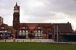 |
Opened for over 1000 pupils.[12] Now Cromwell Street Junior School, Nechells.[12] | 1889 J. A. Cossins | SP084886 | 52°29′43″N 1°52′30″W / 52.4953°N 1.8749°W | Grade II listed | Historic England. "Cromwell Junior and Infant School (Grade II) (1407723)". National Heritage List for England. Retrieved 2 February 2015. |
Other board schools
- Cotteridge School, 1900[13]
Using source:[3]
- Soho Road (Benson Road). Benson Junior School, Benson Road, Winson Road, 1888,[9] Grade II listed, Historic England. "Details from image database (216775)". Images of England.
- Grove Junior School, Grove Lane, Handsworth, late 19th century, Grade II listed, Historic England. "Details from image database (217185)". Images of England.
Using source:[5]
- Constitution Hill 1883 (demolished 1967)
- Upper Highgate Street (demolished)
- Moseley Road
- Marlborough Road School 1896
Other board schools acquired in 1891 when Birmingham was expanded
| Birmingham Board Schools | |||||||
|---|---|---|---|---|---|---|---|
| Name | Picture | Address, Notes | Architect | Grid reference | Coordinates | Grade | Images of England link |
| Clifton Road School | 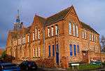 | Clifton Road School, Balsall Heath. 1878 by Kings Norton School Board. Now used by St Paul's Trust.[14] | 1878 M&C (or George Ingall[9]) | SP081842 | 52°27′22″N 1°52′51″W / 52.4560°N 1.8809°W | ||
| Tindal Street School | 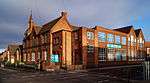 | Tindal Street School, Balsall Heath, 1880 by Kings Norton School Board.[15] | 1879–80 M&C (or George Ingall[9]) | SP075841 | 52°27′18″N 1°53′19″W / 52.4551°N 1.8886°W | ||
- Kings Norton Village Board School, 1878 by Kings Norton School Board.[16]
- Mary Street School, Balsall Heath, 1878 by Kings Norton School Board. Demolished.[17]
- Stirchley Street School, 1879 by Kings Norton School Board.[18]
Other schools from the board school era
| Birmingham Board Schools | |||||||
|---|---|---|---|---|---|---|---|
| Name | Picture | Address, Notes | Architect | Grid reference | Coordinates | Grade | Images of England link |
| Camp Hill Circus School |  | Listed as City of Birmingham Polytechnic. Built as the original King Edward VI Camp Hill School for Boys (so not run by the School Board) (used until 1956), and extended with a school for girls. Tower and roof damaged by fire in 1901.[4] Now the Bordesley Centre, run by Muath Welfare Trust. | 1883 M&C [2] | SP083856 | 52°28′05″N 1°52′41″W / 52.468°N 1.878°W | Grade II listed | Historic England. "Details from image database (217655)". Images of England. |
See also
- Birmingham board schools – history
- List of former board schools in Brighton and Hove
- London School Board
References
- 1 2 3 4 5 6 Buildings of England – Warwickshire, Nikolaus Pevsner and Alexandra Wedgwood, 1966, 1974, ISBN 0-14-071031-0
- 1 2 3 4 5 6 7
- Victorian Architecture in Britain – Blue Guide, Julian Orbach, 1987, ISBN 0-393-30070-6
- 1 2 3 4 5 6 Images of England
- 1 2 King Edward VI Camp Hill School for Boys 1813–1983, D I Thomas
- 1 2 3 4 5 6 7 8 9 The Best Building in the Neighbourhood?, Martin and Chamberlain and the Birmingham Board Schools, The Victorian Society, West Midlands Group, May 1968, F. W. Greenacre, Birmingham Central Library, Birmingham Collection B.Col 48.33
- 1 2 Digital Ladywood (photographs of Birmingham)
- 1 2 3 Ordnance Survey Maps 1890
- ↑ Victorian Society Newsletter, September 2010, p11.
- 1 2 3 4 Thornton, Roy (2006). Victorian Buildings of Birmingham. Sutton Publishing Ltd. ISBN 0-7509-3857-9.
- ↑ University of Birmingham Domus – Floodgate School PDF 24Kb
- ↑ University of Birmingham Domus – Somerville School – PDF 37 Kb
- 1 2 3 "Nechells". William Dargue - A History of Birmingham Places and Names. Retrieved 2 February 2015.
- ↑ The National Archives, Cotteridge School
- ↑ Digital Balsall Heath, Clifton Road
- ↑ Digital Balsall Heath, Tindal Street
- ↑ A History of Birmingham Placenames, Kings Norton School
- ↑ Digital Balsall Heath, Mary Street
- ↑ A History of Birmingham Placenames, Stirchley School
Further reading
- John Ruskin and Victorian Architecture, Michael W Brooks, 1989
This article is issued from Wikipedia - version of the 8/13/2016. The text is available under the Creative Commons Attribution/Share Alike but additional terms may apply for the media files.