List of ancient woods in England
This list of ancient woods in England contains areas of ancient woodland in England larger than ten hectares. The list is arranged alphabetically by ceremonial county.
B
Bedfordshire
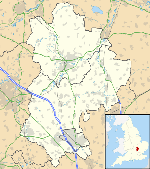
The woodlands of Bedfordshire cover 6.2% of the county.[1] Some two thirds of this (4,990ha) is broadleaved woodland, principally oak and ash.[2] A woodland Trust estimate of all ancient woodland in Bedfordshire (dating back to at least the year 1600), including woods of 0.1ha and upward suggests an area of 1468ha.[3] This list of Bedfordshire's ancient woodland shows only those woods of over 10ha, all of which have SSSI status, and cover a total of 628ha. Of the eight woods shown, five fall roughly on the line of heavily wooded sandstone that runs diagonally across the county south of Bedford.[4]
| Northants. | Northants. Cambs. | Cambs. |
| Bucks. | Bedfordshire. | Cambs. Herts. |
| Bucks. | Herts. | Herts. |
| No. | Name | Public Access | Location | Area | References | |
|---|---|---|---|---|---|---|
| Ha | Acres | |||||
| 1 | Hanger Wood | | 52°08′02″N 0°32′52″W / 52.1339°N 0.5477°W SP 995494 |
24 | 59 | SSSI[5] |
| 2 | King's and Baker's Woods | | 51°57′23″N 0°39′30″W / 51.9563°N 0.6582°W SP 923295 |
212 | 524 | SSSI[6] NNR[7] BNCPWT[8] |
| 3 | Kingswood, Houghton Conquest | | 52°03′01″N 0°28′39″W / 52.0503°N 0.4775°W TL 045402 |
26 | 64 | SSSI[9] Local Gov[10] |
| 4 | Maulden Wood | | 52°02′14″N 0°17′45″W / 52.0371°N 0.2957°W TL 170390 |
149 | 368 | SSSI[11] FC[12] |
| 5 | Odell Great Wood | | 52°13′15″N 0°35′56″W / 52.2209°N 0.599°W SP 958590 |
86 | 212 | SSSI[13] Local Gov[14] |
| 6 | Potton Wood | | 52°08′09″N 0°10′20″W / 52.1359°N 0.1721°W TL 252502 |
85 | 210 | SSSI[15] FC[16] |
| 7 | Southill Lake And Woods | | 52°04′18″N 0°20′12″W / 52.0718°N 0.3367°W TL 141428 |
25 | 62 | SSSI[17] |
| 8 | Swineshead Wood | | 52°17′21″N 0°26′45″W / 52.2891°N 0.4459°W TL 061668 |
21 | 52 | SSSI[18] WT[19] |
Berkshire


Berkshire has woodland covering 18,304ha, which is 14.5% of its land area.[20] The woodlands listed below are all ancient woods of 10ha or more, and these cover some 2,403ha. A major proportion of the area is the area of woodland along the Surrey and Buckinghamshire borders. This is Windsor Great Park and Forest, and as well as the woodland area listed here, it has vast tracts of heath and parkland.[21] Also in the east of the county are woodlands on the southern end of the Chiltern Hills. The great majority of the woods listed are in West Berkshire and follow the line of the chalk hills across the county.[22]
| Wilts. | Oxen. Bucks. | Bucks. |
| Wilts. | Berkshire. | London. |
| Wilts. | Hants. | Surrey |
City of Bristol
| Estuary | Glocs. | Glocs. |
| Somerset | City of Bristol | Glocs. |
| Somerset | Somerset | Somerset |
There is only one sizeable area of Ancient Woodland within Bristol. The Avon Gorge SSSI is partly within the city boundary,[41] but the woodland is mainly in Somerset, so is covered under that county.
Buckinghamshire


9.4% of the land area of Buckinghamshire is Woodland.[42]
C
Cambridgeshire

The ancient woods listed here are those over 10 ha. With one exception, these are all SSSIs.[43] The woods are distributed very unevenly. Large areas of the fenland in the north-eastern side of the county have none. There are significant numbers in the south, toward Suffolk. More of the woods are found in the western half of the county, with three near Peterborough.
Cheshire

Cheshire has some 4% of its area under woodland - around half the national average.[77] Since 1994 the Mersey Community Forest has been promoting new woodland planting within the Merseyside and Cheshire region to alleviate this deficit, and also better manage the existing woodland to secure its future.[78] Cheshire has less ancient woodland, and in smaller units than most counties. Many of the ancient woodlands survive in steep valleys or cloughs, of small extent.[79] Taylor's Rough, Wellmeadow Wood, Warburton's Wood And Well Wood are examples of clough woodland too small for inclusion in this list. Most of the ancient woodland in the county is in units smaller than 10 ha and 65% of the area is in woods smaller than 5 ha.[80] The list below is of ancient woodland larger than 10 ha.
| No. | Woodland | Public access | Grid ref. & map link | Area (ha) | Citation website |
|---|---|---|---|---|---|
| 1 | Peckforton Woods | Yes | SJ 523577 | 54 ha | SSSI |
| 2 | Roe Park Woods | Yes | SJ 860585 | 34.6 ha | SSSI Wildlife Trust |
| 3 | Wettenhall and Darnhall Woods | SJ 640624 | 52.6 ha | SSSI | |
| 4 | Wimboldsley Wood | SJ 675642 | 19 ha | SSSI |
City of London
No Ancient Woodland remains in the City of London although the City of London Corporation are directly responsible for large areas of woodland elsewhere, notably Epping Forest (Essex), Highgate Wood (Greater London) and Burnham Beeches (Bucks)
Cornwall

The county of Cornwall has woodland representing 7.5% of the Land Area.[81]
Cumbria

9.5% of the land area of Cumbria is woodland.[82]
D
Devon
Dorset
- Duncliffe Wood[83]
- Holt Heath
- Powerstock Common[84][85]
- Thorncombe woods[86]
Durham
- Brignall Banks SSSI
- Castle Eden Dene NNR
- Hawthorn Dene SSSI
- Hesleden Dene
- Deepdale Wood
- Pontburn Wood
- Derwent Gorge NNR
E
East Sussex
16.7% of the land area of East Sussex is woodland.[87]
Essex
- Epping Forest
- Hadleigh Woods[88]
- Hockley Woods[89]
- Hatfield Forest
- Nevendon Bushes
G
Gloucestershire
11.2% of the land area of Gloucestershire is woodland.[90]
Greater London
- Bluebell Wood
- Cherry Tree Wood
- Coldfall Wood
- Highgate Wood
- Oxleas Wood
- Queen's Wood
- Great North Wood
- Scratchwood
Greater Manchester
Kersal Landslide
H
Hampshire
17.7% of the Land Area of Hampshire is woodland.[91]
Hertfordshire
9.5% of Hertfordshire's land area is woodland.[92] Birchanger Wood, near Bishop's Stortford Whippendell Wood, 160 acres, Watford
I
Isle of Wight
- Brading Wood, part of the Brading Marshes RSPB reserve
- Parkhurst Forest
K
Kent
10.6% of Kent's land area is wooded.[93]
- Bedgebury Forest
- Barrows Wood, Trundle Wood and High Wood around Wormshill
L
Lancashire
- Boilton, Nab, Red Scar & Tun Brook woods, Preston
Leicestershire

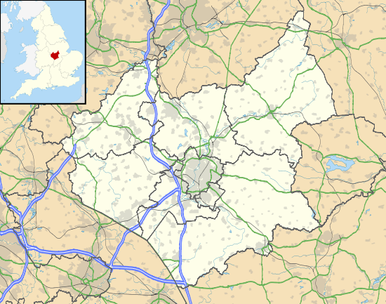
It is estimated that 2% of Leicestershire's land area is ancient woodland, of which half has been replaced by new plantings in recent times.[94] There are over 100 woods in Leicestershire believed to be ancient.[95] The sites listed below are those over 10ha in size, and with one exception, all have SSSI status.[96] With one group of woods near Hinckley, in the south-west, the remainder fall into three broad areas. In East Leicestershire, close to the border with Rutland, are the woods near Leighfield Forest, an extensive Royal Forest which straddled the two counties.[97] North west of Leicester are the woods of Charnwood Forest. Further west are the woods of the coal measures toward the border with Derbyshire.
| Derbys. | Notts. | Lincs. |
| Staffs. Warks. |
Leicestershire. | Rutland |
| Warks. | Northants. | Northants. |

Lincolnshire
- Bradley Woods, Grimsby
- Stapleford Woods, Stapleford, North Kesteven
- Reddings Woods, Kirkby on Bain, Lincolnshire, East Lindsey
M
Middlesex
N
Norfolk
North Yorkshire
- [[Grass Wood, Wharfedale
Nidd gorge Knaresborough ]]
Northamptonshire

The ancient woods of Northants are concentrated towards the south and west of the county, to that region bordering Bucks, Oxford and Beds. Many are managed by the Forestry Commission, although others are in private hands. They tend to occur on limestone soils in elevated country, and exhibit a diversity of habitats.
- Hazleborough Wood, part of Whittlewood Forest
- Royal Forest of Rockingham
- Salcey Forest
- Whittlewood Forest
- Yardley Chase
Northumberland
Whittle Dene
Nottinghamshire
O
Oxfordshire

The ancient woods of Oxfordshire are concentrated in three distinct areas. In the south are woods of the Chiltern Hills. A second cluster lies to the east of Oxford. The Cotswolds woods on the western side of the county include those in the Royal Forest of Wychwood. Oxfordshire has nearly 18,000 ha of woodland in total (6.9% of its area), two-thirds of which are in woods of over 10 ha. 1,839 ha of woodland is represented in the 17 ancient woods listed below. Some 6,000 ha of woodland is split among the 3,390 woods smaller than 10 ha.[119] Many of these smaller woods may be ancient, but are not covered by this list. The list here covers woods of over 10 ha with SSSI status.[120]


R
Rutland
- Burley Wood[140]
- Prior's Coppice[141]
S
Shropshire
- Wyre Forest bordering Worcestershire
Somerset
Somerset is a rural county of rolling hills such as the Blackdown Hills, Mendip Hills, Quantock Hills and Exmoor National Park, and large flat expanses of land including the Somerset Levels. Many of the woodland areas have been designated as SSSIs with some being managed by the Avon Wildlife Trust or Somerset Wildlife Trust. Woodland covers seven per cent of the land area of the county.[142]
South Yorkshire
Staffordshire
Suffolk
- Arger Fen and Spouses Grove
- Assington Thicks
- Bradfield Woods
- Bull's Wood
- Snakes Wood
- Staverton Park-Butley
- Wolves Wood
Surrey
22.4% of the Land Area of Surrey is woodland [169] this makes it the most wooded county in England.[170]
Tyne and Wear
- Thornley Wood SSSI
- Derwent Walk Country Park woods
- Stanley Burn Wood
- Snipes Dene Wood, part of Gibside SSSI
- Lands Wood, Winlaton Mill
W
Warwickshire
West Midlands
West Sussex
18.9% of West Sussex's land area is woodland.[171]
West Yorkshire
- Batty's Wood
Wiltshire
Worcestershire
- Grafton Wood
- Laight Rough,
- Pepper Wood[172]
- Shrawley Wood
- Wyre Forest bordering Shropshire
See also
Notes
- ↑ Forestry Commission: National Inventory of Woodland and Trees County Report for Bedfordshire 2002, p.2
- ↑ Forestry Commission: National Inventory of Woodland and Trees County Report for Bedfordshire 2002, p.11
- ↑ "Bedfordshire and Luton Habitat Action Plan: Lowland Mixed Deciduous Woodland" (PDF). 2008. Retrieved 20 September 2011.
- ↑ "Geology map of Bedfordshire". Retrieved 20 September 2011.
- ↑ "SSSI:Hanger Wood, Beds." (PDF). Natural England. Retrieved 25 November 2011.
- ↑ "SSSI:King's and Baker's Woods, Beds." (PDF). Natural England. Retrieved 25 November 2011.
- ↑ King's and Baker's Woods NNR
- ↑ King's and Baker's Woods, BCNP Wildlife Trust
- ↑ "SSSI:Kingswood, Houghton Conquest, Beds." (PDF). Natural England. Retrieved 25 November 2011.
- ↑ Central Bedfordshire Council – Kingswood
- ↑ "SSSI:Maulden Wood, Beds." (PDF). Natural England. Retrieved 25 November 2011.
- ↑ Maulden Wood - Forestry Commission
- ↑ "SSSI:Odell Great Wood, Beds." (PDF). Natural England. Retrieved 25 November 2011.
- ↑ Odell Country Park: Bedord Borough Counci
- ↑ "SSSI:Potton Wood, Beds." (PDF). Natural England. Retrieved 25 November 2011.
- ↑ Potton Wood, Beds.:Forestry Commission
- ↑ "SSSI:Southill Lake And Woods, Beds." (PDF). Natural England. Retrieved 25 November 2011.
- ↑ "SSSI:Swineshead Wood, Beds." (PDF). Natural England. Retrieved 25 November 2011.
- ↑ Archived 29 March 2012 at the Wayback Machine.
- ↑ "Forestry Commission: National Inventory of Woodland and Trees County Report for Berkshire" (PDF). 2002. Retrieved 8 October 2011.
- ↑ "Woodland Trust: Focus on Berkshire". Retrieved 8 October 2011.
- ↑ "Berkshire Geoconservation Group: Geology of Berkshire". Retrieved 8 October 2011.
- ↑ "SSSI: Ashridge Wood, Berks." (PDF). Natural England. Retrieved 5 February 2012.
- ↑ "SSSI: Bisham Woods, Berks." (PDF). Natural England. Retrieved 5 February 2012.
- ↑ Bisham Woods: Woodland Trust
- ↑ "SSSI: Bowdown and Chamberhouse Woods, Berks." (PDF). Natural England. Retrieved 5 February 2012.
- ↑ Bowdown & Chamberhouse Woods: Berks Bucks & Oxon Wildlife Trust
- ↑ "SSSI: Catmore And Winterly Copses , Berks." (PDF). Natural England. Retrieved 5 February 2012.
- ↑ "SSSI: Combe Wood And Linkenholt Hanging, Berks." (PDF). Natural England. Retrieved 5 February 2012.
- ↑ "SSSI: Coombe Wood, Frilsham, Berks." (PDF). Natural England. Retrieved 5 February 2012.
- ↑ "SSSI: Enborne Copse, Berks." (PDF). Natural England. Retrieved 5 February 2012.
- ↑ "SSSI: Great Thrift Wood, Berks." (PDF). Natural England. Retrieved 5 February 2012.
- ↑ "SSSI: Irish Hill Copse, Berks." (PDF). Natural England. Retrieved 5 February 2012.
- ↑ "SSSI: Kennet Valley Alderwoods, Berks." (PDF). Natural England. Retrieved 5 February 2012.
- ↑ "SSSI: King's Copse, Berks." (PDF). Natural England. Retrieved 5 February 2012.
- ↑ "SSSI: Redhill Wood, Berks." (PDF). Natural England. Retrieved 5 February 2012.
- ↑ "SSSI: Snelsmore Common, Berks." (PDF). Natural England. Retrieved 5 February 2012.
- ↑ Archived 27 September 2011 at the Wayback Machine.
- ↑ "SSSI: Windsor Great Park, Berks." (PDF). Natural England. Retrieved 5 February 2012.
- ↑ "Windsor Great Park". The Crown Estate. Retrieved 23 February 2014.
- ↑ Avon Gorge SSSI Citation
- ↑ "National Inventory of Woodland and Trees : Buckinghamshire" (PDF). Forestry.gov.uk. Retrieved 23 February 2014.
- ↑ Natural England SSSI search for Cambridgeshire
- ↑ "SSSI: Aversley Wood, Cambs." (PDF). Natural England. Retrieved 5 February 2012.
- ↑ Woodland Trust Aversley Wood, Cambs
- ↑ "SSSI: Balsham Wood, Cambs." (PDF). Natural England. Retrieved 5 February 2012.
- ↑ "SSSI: Bedford Purlieus NNR, Cambs." (PDF). Natural England. Retrieved 5 February 2012.
- ↑ NNR
- ↑ Bedford Purlieus, Cambs. Forestry Commission
- ↑ "SSSI: Brampton Wood, Cambs." (PDF). Natural England. Retrieved 5 February 2012.
- ↑ BCPN Wildlife Trust, Brampton Wood
- ↑ "SSSI: Buff Wood, Cambs." (PDF). Natural England. Retrieved 5 February 2012.
- ↑ BCPN Wildlife Trust, Buff Wood
- ↑ "SSSI: Carlton Wood, Cambs." (PDF). Natural England. Retrieved 5 February 2012.
- ↑ "SSSI: Gamlingay Wood, Cambs." (PDF). Natural England. Retrieved 5 February 2012.
- ↑ BCPN Wildlife Trust Carlton Wood
- ↑ "SSSI: Hardwick Wood, Cambs." (PDF). Natural England. Retrieved 5 February 2012.
- ↑ BCPN Wildlife Trust, Carlton Wood
- ↑ "SSSI: Hayley Wood, Cambs." (PDF). Natural England. Retrieved 5 February 2012.
- ↑ BCPN Wildlife Trust, Hayley Wood
- ↑ "SSSI: Kingston Wood and Outliers, Cambs." (PDF). Natural England. Retrieved 5 February 2012.
- ↑ "SSSI: Langley Wood, Cambs." (PDF). Natural England. Retrieved 5 February 2012.
- ↑ "SSSI: Little Paxton Wood, Cambs." (PDF). Natural England. Retrieved 5 February 2012.
- ↑ "SSSI: Madingley Wood, Cambs." (PDF). Natural England. Retrieved 5 February 2012.
- ↑ "SSSI: Monks Wood NNR, Cambs." (PDF). Natural England. Retrieved 5 February 2012.
- ↑ Natural England NNR, Monks Wood
- ↑ "SSSI: Out and Plunder Woods, Cambs." (PDF). Natural England. Retrieved 5 February 2012.
- ↑ "SSSI: Over and Lawn Woods, Cambs." (PDF). Natural England. Retrieved 5 February 2012.
- ↑ "SSSI: Perry Woods, Cambs." (PDF). Natural England. Retrieved 5 February 2012.
- ↑ "SSSI: Ten Wood, Cambs." (PDF). Natural England. Retrieved 5 February 2012.
- ↑ "SSSI: Thorpe Wood, Cambs." (PDF). Natural England. Retrieved 5 February 2012.
- ↑ BCNP Wildlife Trust, Thorpe Wood
- ↑ "SSSI: Warboy's And Wistow Woods, Cambs." (PDF). Natural England. Retrieved 5 February 2012.
- ↑ "SSSI: Waresley Wood, Cambs." (PDF). Natural England. Retrieved 5 February 2012.
- ↑ "SSSI: Weaveley and Sand Woods, Cambs." (PDF). Natural England. Retrieved 5 February 2012.
- ↑ "SSSI: West, Abbot's and Lound Woods, Cambs." (PDF). Natural England. Retrieved 5 February 2012.
- ↑ http://www2.halton.gov.uk/pdfs/environment/ancientwoodlands
- ↑ Mersey Community Forest
- ↑ "Cheshire : Taylor's Rough & Wellmeadow Wood" (PDF). Sssi.naturalengland.org.uk. Retrieved 23 February 2014.
- ↑ Archived 21 November 2010 at the Wayback Machine.
- ↑ "Cornwall.Pdf" (PDF). Retrieved 21 February 2014.
- ↑ "National Inventory of Woodland and Trees : Cumbria" (PDF). Forestry.gov.uk. Retrieved 23 February 2014.
- ↑ "Duncliffe Wood | Visiting woods | The Duncliffe Woodland Trust". Woodlandtrust.org.uk. Retrieved 23 February 2014.
- ↑ "Powerstock Common - Dorset AONB Partnership". Dorsetaonb.org.uk. Retrieved 23 February 2014.
- ↑ "Powerstock Common: a Dorset Wildlife Trust nature reserve". Dorsetwildlifetrust.org.uk. Retrieved 23 February 2014.
- ↑ "Thorncombe Woods". dorsetforyou.com. Retrieved 23 February 2014.
- ↑ "National Inventory of Woodland and Trees : East Sussex" (PDF). Forestry.gov.uk. Retrieved 23 February 2014.
- ↑ Rackham 1992, p. 82.
- ↑ Rackham 1992, p. 62.
- ↑ "National Inventory of Woodland and Trees : Gloucestershire" (PDF). Forestry.gov.uk. Retrieved 23 February 2014.
- ↑ "National Inventory of Woodland and Trees : Hampshire" (PDF). Forestry.gov.uk. Retrieved 23 February 2014.
- ↑ "National Inventory of Woodland and Trees : Hertfordshire" (PDF). Forestry.gov.uk. Retrieved 23 February 2014.
- ↑ "National Inventory of Woodland and Trees : Kent" (PDF). Forestry.gov.uk. Retrieved 23 February 2014.
- ↑ Wooded Wonders, exploring the natural heritage of ancient woodlands Leicestershire County Council, 2000. p.3
- ↑ Squires 1994, p. 140.
- ↑ "Leicestershire SSSIs". Sssi.naturalengland.org.uk. Retrieved 23 February 2014.
- ↑ Squires 1994, p. 49.
- ↑ "SSSI:Allexton Wood, Leicestershire" (PDF). Natural England. Retrieved 25 November 2011.
- ↑ "SSSI:Buddon Wood, Quorn, Leicestershire" (PDF). Natural England. Retrieved 25 November 2011.
- ↑ "SSSI:Burbage and Sheepy Woods, Leicestershire" (PDF). Natural England. Retrieved 25 November 2011.
- ↑ "Burbage Common and Woods Visitor Centre" (PDF). Hinckley and Bosworth Council. Retrieved 10 September 2011.
- ↑ "SSSI:Cloud Wood, Breedon, Leicestershire" (PDF). Natural England. Retrieved 25 November 2011.
- ↑ "Cloud Wood". LRWT. Retrieved 10 September 2011.
- ↑ "SSSI:Dimminsdale, Leicestershire" (PDF). Natural England. Retrieved 25 November 2011.
- ↑ "Dimminsdale". LRWT. Retrieved 10 September 2011.
- ↑ "SSSI:Eye Brook Valley Woods, Leicestershire" (PDF). Natural England. Retrieved 25 November 2011.
- ↑ "Great Merrible Wood". LRWT. Retrieved 10 September 2011.
- ↑ "SSSI:Grace Dieu Wood, Leicestershire" (PDF). Natural England. Retrieved 25 November 2011.
- ↑ "SSSI:Outwoods, Leicestershire" (PDF). Natural England. Retrieved 25 November 2011.
- ↑ "The Outwoods" (PDF). Charnwood Council. Retrieved 10 September 2011.
- ↑ "SSSI:Launde Big Wood and Launde Park Wood, Leicestershire" (PDF). Natural England. Retrieved 25 November 2011.
- ↑ "/Launde Woods". LRWT. Retrieved 10 September 2011.
- ↑ "/Martinshaw Woods". Woodland Trust. Retrieved 10 September 2011.
- ↑ "SSSI:Owston Woods, Leicestershire" (PDF). Natural England. Retrieved 25 November 2011.
- ↑ "SSSI:Pasture and Asplin Woods, Breedon, Leicestershire" (PDF). Natural England. Retrieved 25 November 2011.
- ↑ "SSSI:Skeffington and Tilton Woods, Leicestershire" (PDF). Natural England. Retrieved 25 November 2011.
- ↑ "SSSI:Swithland Wood, Leicestershire" (PDF). Natural England. Retrieved 25 November 2011.
- ↑ Woodward, Stephen, 1992, Swithland Wood: A study of its History and Vegetation, LMARS
- ↑ Data on Oxfordshire Woodlands, Oxfordshire County Council, 2002 figures.
- ↑ "Oxfordshire SSSIs". Sssi.naturalengland.org.uk. Retrieved 23 February 2014.
- ↑ "SSSI:Aston Rowant Woods, Oxfordshire" (PDF). Natural England. Retrieved 25 November 2011.
- ↑ "SSSI:Bear, Oveys and Great Bottom Woods, Oxfordshire" (PDF). Natural England. Retrieved 25 November 2011.
- ↑ "SSSI:Bould Wood, Oxfordshire" (PDF). Natural England. Retrieved 25 November 2011.
- ↑ "SSSI:Harpsden Wood, Oxfordshire" (PDF). Natural England. Retrieved 25 November 2011.
- ↑ Woodland Trust page for Harpsden Woods, Oxon
- ↑ "SSSI:Holly Wood, Leicestershire" (PDF). Natural England. Retrieved 25 November 2011.
- ↑ "SSSI:Holton Wood, Oxfordshire" (PDF). Natural England. Retrieved 25 November 2011.
- ↑ "SSSI:Lambridge Wood, Oxfordshire" (PDF). Natural England. Retrieved 25 November 2011.
- ↑ "SSSI:Out Wood, Oxfordshire" (PDF). Natural England. Retrieved 25 November 2011.
- ↑ "SSSI:Pishill Woods, Oxfordshire" (PDF). Natural England. Retrieved 25 November 2011.
- ↑ "SSSI:Sarsgrove Wood , Oxfordshire" (PDF). Natural England. Retrieved 25 November 2011.
- ↑ "SSSI:Stanton Great Wood , Oxfordshire" (PDF). Natural England. Retrieved 25 November 2011.
- ↑ "SSSI:Sturt Copse , Oxfordshire" (PDF). Natural England. Retrieved 25 November 2011.
- ↑ "SSSI:Waterperry Wood , Oxfordshire" (PDF). Natural England. Retrieved 25 November 2011.
- ↑ "SSSI:Whitecross Green and Oriel Woods, Oxfordshire" (PDF). Natural England. Retrieved 25 November 2011.
- ↑ Wildlife Trust page for Oriel Woods, Oxon
- ↑ "SSSI:Woodeaton Wood, Oxfordshire" (PDF). Natural England. Retrieved 25 November 2011.
- ↑ "SSSI:Wychwood , Oxfordshire" (PDF). Natural England. Retrieved 25 November 2011.
- ↑ "Foxholes | Berks, Bucks & Oxon Wildlife Trust". Bbowt.org.uk. Retrieved 23 February 2014.
- ↑ Squires 1994, p. 133.
- ↑ Squires 1994, p. 117.
- ↑ "National inventory of woodland and trees: Somerset" (PDF). Forestry Commission. Retrieved 25 November 2011.
- ↑ "Aller and Beer Woods" (PDF). Natural England. Retrieved 25 November 2011.
- ↑ "Aller and Beer Woods". Wildlife Trusts. Retrieved 25 November 2011.
- ↑ "Asham Woods" (PDF). Natural England. Retrieved 25 November 2011.
- ↑ "Cheddar Wood" (PDF). Natural England. Retrieved 25 November 2011.
- ↑ "Cogley Wood" (PDF). Natural England. Retrieved 25 November 2011.
- ↑ "Dunkery & Horner Woods NNR". Special Sites. Natural England. Retrieved 25 November 2011.
- ↑ "Edford Woods and Meadows" (PDF). Natural England. Retrieved 25 November 2011.
- ↑ "Great Breach and Copley Woods" (PDF). Natural England. Retrieved 25 November 2011.
- ↑ "Harridge Woods". Somerset Wildlife Trust. Retrieved 25 November 2011.
- ↑ "Hawkcombe Woods NNR". Natural England. Retrieved 25 November 2011.
- ↑ "North Exmoor" (PDF). Natural England. Retrieved 25 November 2011.
- ↑ "Avon Gorge SSSI" (PDF). Natural England. Retrieved 25 November 2011.
- ↑ "Leigh Woods NNR". Natural England. Retrieved 25 November 2011.
- ↑ "Leigh Woods". Avon Gorge and Downs Wildlife project. Retrieved 25 November 2011.
- ↑ "Leigh Woods". National Trust. Retrieved 25 November 2011.
- ↑ "Longleat Woods" (PDF). Natural England. Retrieved 25 November 2011.
- ↑ "Long Dole Wood and Meadows" (PDF). Natural England. Retrieved 4 December 2011.
- ↑ "Neroche Scheme". Neroche. Retrieved 25 November 2011.
- ↑ "Postlebury Wood" (PDF). Natural England. Retrieved 25 November 2011.
- ↑ "Prior's Park & Adcombe Wood" (PDF). Natural England. Retrieved 25 November 2011.
- ↑ "Sparkford Wood" (PDF). Natural England. Retrieved 25 November 2011.
- ↑ "Thurlbear Wood and Quarrylands" (PDF). Natural England. Retrieved 25 November 2011.
- ↑ "Towerhouse Wood". Woodland Trust. Retrieved 25 November 2011.
- ↑ "Twinhills Woods and Meadows" (PDF). Natural England. Retrieved 25 November 2011.
- ↑ "Weston Big Wood" (PDF). Natural England. Retrieved 25 November 2011.
- ↑ "Weston Big Wood". Reserves. Avon Wildlife Trust. Retrieved 25 November 2011.
- ↑ "Surrey.Pdf" (PDF). Retrieved 21 February 2014.
- ↑ "inventory.pub" (PDF). Retrieved 21 February 2014.
- ↑ "National Inventory of Woodland and Trees : West Sussex" (PDF). Forestry.gov.uk. Retrieved 23 February 2014.
- ↑ "Pepper Wood". Woodland Trust. Retrieved 18 October 2014.
References
- Rackham, Oliver (1992). The Woods of South-East Essex. Rochford District Council. ISBN 0-9511863-0-2.
- Squires, Anthony; Jeeves, Michael (1994). Leicestershire and Rutland Woodlands Past and Present. Kairos Press. ISBN 1-871344-03-4.