Lintgen
| Lintgen Lëntgen | ||
|---|---|---|
| Commune | ||
|
The church | ||
| ||
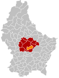 Map of Luxembourg with Lintgen highlighted in orange, and the canton in dark red | ||
| Coordinates: 49°43′00″N 6°08′00″E / 49.7167°N 6.1333°ECoordinates: 49°43′00″N 6°08′00″E / 49.7167°N 6.1333°E | ||
| Country |
| |
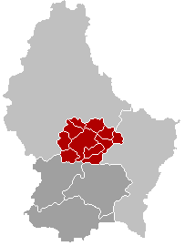
| Canton | Mersch | |
| Government | ||
| • Mayor | Henri Wurth | |
| Area | ||
| • Total | 15.25 km2 (5.89 sq mi) | |
| Area rank | 77 of 105 | |
| Highest elevation | 414 m (1,358 ft) | |
| • Rank | 39th of 105 | |
| Lowest elevation | 216 m (709 ft) | |
| • Rank | 34th of 105 | |
| Population (2014) | ||
| • Total | 2,770 | |
| • Rank | 49th of 105 | |
| • Density | 180/km2 (470/sq mi) | |
| • Density rank | 38th of 105 | |
| Time zone | CET (UTC+1) | |
| • Summer (DST) | CEST (UTC+2) | |
| LAU 2 | LU00012007 | |
| Website | lintgen.lu | |


Lintgen (Luxembourgish: Lëntgen) is a commune and small town in central Luxembourg, in the canton of Mersch. It is situated on the river Alzette.
As of 2005, the town of Lintgen, which lies in the west of the commune, has a population of 1,686. The number of inhabitants keeps on increasing, therefore ten years later, in 2015 there is approximately 2,798 persons living in Lintgen. Another town within the commune is Gosseldange.
External links
-
 Media related to Lintgen at Wikimedia Commons
 |
Mersch | | ||
| Mersch | |
Fischbach | ||
| ||||
| | ||||
| Lorentzweiler |
 | ||
This article is issued from Wikipedia - version of the 12/1/2016. The text is available under the Creative Commons Attribution/Share Alike but additional terms may apply for the media files.