Limpopo
| Limpopo | ||
|---|---|---|
| Province of South Africa | ||
| ||
| Motto: Peace, Unity and Prosperity | ||
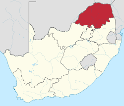 Location of Limpopo in South Africa | ||
| Country | South Africa | |
| Established | 27 April 1994 | |
| Capital | Polokwane | |
| Districts | ||
| Government | ||
| • Type | Parliamentary system | |
| • Premier | Stanley Mathabatha (ANC) | |
| Area[1]:9 | ||
| • Total | 125,754 km2 (48,554 sq mi) | |
| Area rank | 5th in South Africa | |
| Highest elevation | 2,126 m (6,975 ft) | |
| Population (2011)[1]:18[2] | ||
| • Total | 5,404,868 | |
| • Estimate (2015) | 5,726,800 | |
| • Rank | 5th in South Africa | |
| • Density | 43/km2 (110/sq mi) | |
| • Density rank | 5th in South Africa | |
| Population groups[1]:21 | ||
| • Black African | 96.7% | |
| • White | 2.6% | |
| • Indian or Asian | 0.3% | |
| • Coloured | 0.3% | |
| Languages[1]:25 | ||
| • Northern Sotho | 52.9% | |
| • Tsonga | 17.0% | |
| • Venda | 16.7% | |
| • Afrikaans | 2.6% | |
| Time zone | SAST (UTC+2) | |
| ISO 3166 code | ZA-LP | |
| Website | www.limpopo.gov.za | |

Limpopo (UK: /lɪmˈpəʊpəʊ/) is the northernmost province of South Africa. It is named after the Limpopo River, which forms the province's western and northern borders. The name "Limpopo" has its etymological origin in the Northern Sotho language word diphororo tša meetse, meaning "strong gushing waterfalls". The capital is Polokwane, formerly called Pietersburg.
The province was formed from the northern region of Transvaal Province in 1994, and was initially named Northern Transvaal. The following year, it was renamed Northern Province, which remained the name until 2003, when it was formally changed to Limpopo after deliberation by the provincial government and amendment of the South African Constitution. An alternate name considered for the province was Mapungubwe, the area where its most ancient gold-using civilization had been discovered a few years earlier.
Limpopo has the highest level of poverty of any South African province, with 78.9% of the population living below the national poverty line.[3] In 2011, 74.4% of local dwellings were located in a tribal or traditional area, compared to a national average of 27.1%.[4] The Northern Sotho language is spoken by more than half of Limpopo's population.
Geography
Limpopo Province shares international borders with districts and provinces of three countries: Botswana's Central and Kgatleng districts to the west and northwest respectively, Zimbabwe's Matabeleland South and Masvingo provinces to the north and northeast respectively, and Mozambique's Gaza Province to the east.[5] Limpopo is the link between South Africa and countries further afield in sub-Saharan Africa. On its southern edge, from east to west, it shares borders with the South African provinces of Mpumalanga, Gauteng, and North West. Its border with Gauteng includes that province's Johannesburg-Pretoria axis, the most industrialized metropole on the continent. The province is at the centre of regional, national, and international developing markets.
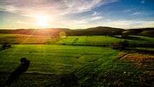
Limpopo contains much of the Waterberg Biosphere, a massif of approximately 15,000 km2 (5,800 sq mi) which is the first region in the northern part of South Africa to be named a UNESCO Biosphere Reserve. The massif was shaped by hundreds of millions of years of riverine erosion yielding diverse bluff and butte landforms.[6] The Waterberg ecosystem can be characterized as a dry deciduous forest or Bushveld. Within the Waterberg, archaeological finds date to the Stone Age. Nearby are early evolutionary finds related to the origin of humans.
Law and government
The current premier of Limpopo Province is Stanley Mathabatha, representing the African National Congress.
Municipalities
Limpopo Province is divided into five municipal districts, which themselves are subdivided into 25 local municipalities:
Economy
The province is a typical developing area, exporting primary products and importing manufactured goods and services. It is also one of the poorest regions of South Africa with a big gap between poor and rich residents, especially in rural areas.[7] However, Limpopo's economy and standard of living have shown great improvement. A recent border shift with Limpopo's wealthier neighbour, Mpumalanga, was effected to try and bring some wealth into the province.
Agriculture
The bushveld is beef cattle country, where extensive ranching operations are often supplemented by controlled hunting. About 80% of South Africa's game hunting industry is found in Limpopo.
Sunflowers, cotton, maize and peanuts are cultivated in the Bela-Bela and Modimolle areas. Modimolle is also known for its table grapes. Tropical fruit, such as bananas, litchis, pineapples, mangoes and pawpaws, as well as a variety of nuts, are grown in the Tzaneen and Louis Trichardt areas. Tzaneen is also at the centre of extensive citrus, tea and coffee plantations, and a major forestry industry.
Mining
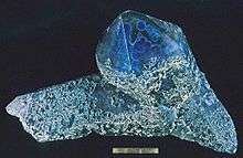
Limpopo's rich mineral deposits include the platinum group metals, iron ore, chromium, high- and middle-grade coking coal, diamonds, antimony, phosphate, and copper, as well as mineral reserves like gold, emeralds, scheelite, magnetite, vermiculite, silicon, and mica. Commodities such as black granite, corundum, and feldspar are also found. Mining contributes to over a fifth of the provincial economy.
Limpopo has the largest platinum deposit in South Africa. The Waterberg Coalfield, the eastern extension of Botswana's Mmamabula coalfields, is estimated to contain 40% of South Africa's coal reserves.[8]
Tourism
Tourism is one of the three pillars of the Limpopo economy along with mining and agribusiness.[9] In 2008, the Province accounted for 5% of all foreign tourist bed nights in South Africa, numbers which are showing strong annual growth. The R 93 million Provincial tourism budget for 2010/11 represents 11% of Limpopo's total budget.[9][10]
Near Modjadjiskloof, at Sunland Baobab farms, there is a large Baobab tree which has been fashioned into a rather spacious pub.[11]
The Limpopo Department of Economic Development, Environment and Tourism has targeted the province as a preferred eco-tourism destination. Its Environment and Tourism Programme encompasses tourism, protected areas and community environment development to achieve sustainable economic growth.[10]
While Limpopo is one of South Africa's poorest provinces, it is rich in wildlife, which gives it an edge in attracting tourists. Both the private and public sectors are investing in tourism development.
Transportation and communications
The province has excellent road, rail, and air links. The N1 route from Johannesburg, which extends the length of the province, is the busiest overland route in Africa in terms of cross-border trade in raw materials and beneficiated goods. The port of Durban, South Africa’s busiest, is served directly by the province, as are the ports of Richards Bay and Maputo. Polokwane International Airport is situated just north of Polokwane.
Education
The Department of Education is charged with the responsibility of effecting quality education and training for all. The Department has to coordinate all professional development and support. Policies, systems, and procedures had to be developed.
Educational institutions
- University of Limpopo (Polokwane, Ga-Rankuwa)
- Comprehensive University of Venda (Thohoyandou)
Sports
- Association football: Polokwane was one of South Africa's host cities for the 2010 FIFA World Cup, with matches being played at the Peter Mokaba Stadium.
- Rugby union: Limpopo has no provincial rugby team of its own; it is represented in the domestic Currie Cup by the Pretoria-based Blue Bulls. The Blue Bulls also operate a Super Rugby franchise, known simply as the Bulls. Limpopo nonetheless produces its share of top players. Most notably, the two most-capped forwards in the history of the country's national team, John Smit and Victor Matfield, are both natives of Polokwane.
Demographics
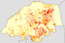
|
<1 /km²
1–3 /km²
3–10 /km²
10–30 /km²
30–100 /km² |
100–300 /km²
300–1000 /km²
1000–3000 /km²
>3000 /km² |

The population of Limpopo consists of several ethnic groups distinguished by culture, language and race. 97.3% of the population is Black, 2.4% is White, 0.2% is Coloured, and 0.1% is Indian/Asian. The province has the smallest percentage and second smallest total number of white South Africans in the country. It also has the highest Black percentage out of all the provinces.
The Northern Sotho people (of which the Bapedi are a part) make up the largest percentage of the black population, being 52% of the province. The Tsonga people comprise about 17.0% of the province; the Tsonga also comprise about 11.5% of Mpumalanga province since the southern part of their homeland, Gazankulu, was cut off from Limpopo and allocated to Mpumalanga. The Venda make up about 16.7%. Afrikaners make up the majority of Limpopo's white population, about 95,000 people; English-speaking whites number just over 20,000. Vhembe district has the smallest share of white people in Limpopo, about 5,000 total, while the Waterberg district has the largest share of whites, with more than 60,000 whites residing there. Coloureds and Asians/Indians make up a very small percentage of the province's total population.
HIV / Aids
At 18.5% (2007), Limpopo has a fairly high incidence of HIV compared to other South African provinces. Cases rose from 14.5% to 21.5% between 2001 and 2005, with a slight fall between 2005 and 2007.[12]
See also
References
- 1 2 3 4 Census 2011: Census in brief (PDF). Pretoria: Statistics South Africa. 2012. ISBN 9780621413885.
- ↑ Mid-year population estimates, 2015 (PDF) (Report). Statistics South Africa. 31 July 2015. p. 3. Retrieved 11 August 2015.
- ↑ "Living condition". Statistics South Africa. Retrieved 24 August 2013.
- ↑ "Community profiles > Census 2011 > Dwellings > Geo type". Statistics South Africa SuperWEB. Retrieved 24 August 2013.
- ↑ "http://www.limpopo.gov.za/index.php?option=com_content&view=article&id=1&Itemid=3". External link in
|title=(help) - ↑ C.Michael Hogan, Mark L. Cooke and Helen Murray, The Waterberg Biosphere, Lumina Technologies, 22 May 2006.
- ↑ http://muse.jhu.edu/login?uri=/journals/eastern_africa_social_science_research_review/v019/19.2gyekye.pdf
- ↑ CIC Energy (February 2012). "Mmamabula Coalfield". Retrieved 2012-09-21.
- 1 2 Budget speech of Limpopo Department of Economic Development and Environment and Tourism 12 March 2010, retrieved 9 July 2010
- 1 2 DEPARTMENT OF ECONOMIC DEVELOPMENT, ENVIRONMENT & TOURISM Budget Speech 2009/2010, retrieved 9 July 2010
- ↑ "The Big Baobab Limpopo South Africa | The Largest Baobab in the World". Bigbaobab.co.za. 2011-03-24. Retrieved 2014-08-02.
- ↑ http://www.avert.org/safricastats.htm -HIV rates in South Africa
External links
| Wikivoyage has a travel guide for Limpopo. |
| Wikimedia Commons has media related to Limpopo. |
| |||||||||||
| Provinces | |||||||||||
| Municipalities |
| ||||||||||
| Settlements |
| ||||||||||
Coordinates: 24°S 29°E / 24°S 29°E