Marsala
| Marsala | ||
|---|---|---|
| Comune | ||
| City of Marsala | ||
|
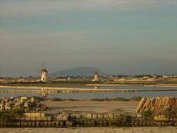
Salt evaporation ponds at Marsala | ||
| ||
 Marsala Location of Marsala in Italy | ||
| Coordinates: 37°48′N 12°26′E / 37.800°N 12.433°E | ||
| Country | Italy | |
| Region | Sicily | |
| Province / Metropolitan city | Trapani (TP) | |
| Government | ||
| • Mayor | Alberto Di Girolamo (PD) | |
| Area | ||
| • Total | 241.6 km2 (93.3 sq mi) | |
| Elevation | 3 m (10 ft) | |
| Population (30 November 2010) | ||
| • Total | 82,765 | |
| • Density | 340/km2 (890/sq mi) | |
| Demonym(s) | Marsalesi or Lilibetani | |
| Time zone | CET (UTC+1) | |
| • Summer (DST) | CEST (UTC+2) | |
| Postal code | 91025 | |
| Dialing code | 0923 | |
| Patron saint | Our Lady of the Cave (Madonna della Cava) and Saint John the Baptist | |
| Saint day | respectively 19 January and 24 June | |
| Website | Official website | |
-Stemma.png)
Marsala (Maissala in Sicilian; Lilybaeum in Latin) is an Italian town located in the Province of Trapani in the westernmost part of Sicily. Marsala is the most populated town in Trapani District and the fifth in Sicily.
The town is famous for the docking of Garibaldi on 11 May 1860 (the Expedition of the Thousand) and for its Marsala wine. A feature of the area is the Natural Reserve called Stagnone Lagoon — a marine area with salt ponds.
Marsala is built on the ruins of the ancient Carthaginian city of Lilybaion, and includes in its territory the archaeological site of Motya island, an ancient Phoenician town.
Geography
Situated at the extreme western point of Sicily, the town was founded on Lilibeo Cape from where the Aegadian Islands and the Stagnone Lagoon can be seen.
Territory
The territory of Marsala, 241 square kilometres (93 sq mi), has a rich cultural and landscape heritage; its area includes the Stagnone Lagoon, a Natural Reserve in which is located the island of Mozia.
The city of Marsala had a population of about 86,000 until the end of 1970, when Petrosino, a village formerly part of Marsala, decided to become a self-governing town after a local referendum.
The area of Marsala is classified as a seismic zone 2 (medium). In the last 200 years three earthquakes of medium-high intensity were recorded:
- 18 May 1828 – magnitude 5.17 (about VI Mercalli scale)
- 15 January 1968 – Belice earthquake which in Marsala reached VII Mercalli scale (although its intensity was as high as X in other locations).
- 7 June 1981 – magnitude 4.60 (IV–V scala Mercalli scale) with epicentre in Borgo Elefante in Mazara del Vallo, about 20 kilometres (12 mi) from the town-centre of Marsala.
Weather
The weather is warm in summer with a maximum of 39 °C (102 °F). Winters are rainy with temperatures between 10 °C (50 °F) and 17 °C (63 °F).
History

In 397 BCE the Phoenician colony of Motya on the southwestern coast of Sicily was invaded and destroyed by the Syracusan tyrant Dionysius I. The survivors founded a town on the mainland nearby that they called Lilybaion (Lilybaeum in Latin), "The town that looks at Libya", on the site of modern-day Marsala.
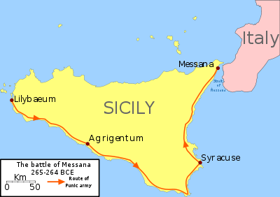
The First Punic War began here when the Punic army landed at Lilybaion in 265/264 BCE, then marched across Sicily to Messina, where the opening clash of the war took place.[1]
Lilybaion was conquered by the Romans in 241 BCE and became one of the most important towns in Sicily. The commercial centre was enriched with mansions and public buildings and dubbed splendidissima urbs by Cicero, who served as quaestor in the region between 76 and 75 BC.
Ravaged by Vandals during the 5th century CE, the town was annexed in the 6th century to Justinian's Byzantine Empire. In this period the town was struck by dysentery, raided by pirates, and neglected by Constantinople. The arrival of Arabic Berbers at the nearby Granitola mount in the 8th century entailed the resumption of commerce and the start of the rebirth of the town. The town was renamed Marsa ʿAlī "ʿAlī's harbour" or maybe, Marsa ʿāliyy, "Big harbour", for the width of the ancient harbour, placed near Punta d'Alga. Another possible derivation is Marsa Allāh, "God's harbour". Another theory is that Marsala comes from mare salis, "salt pans by the sea" from the presence of salt pans along the whole northern coast, although mention of this theory cannot be found in contemporary references and the installation of the bigger salt ponds on the group of islands composing the contemporary single island "Isola Lunga" was made just during 19th century.
Since the end of the 11th century, the area has been conquered by Swedish, Norman, Angevin and Aragonese troops. During this time, Marsala became wealthy, primarily through trade. However the blocking up of the harbour of Punta Alga, decreed by Emperor Charles V so as to stop Saracen forays, brought an end to this period of prosperity.
The development of Marsala wine at the end of the 18th century, headed by English merchants settled in Sicily, considerably improved local trade. This triggered an economic expansion in Marsala, including the funding of infrastructure projects such as the current harbour of Margitello.
On 11 May 1860 Giuseppe Garibaldi landed at Marsala, beginning the process of Italian unification.
On 11 May 1943, in the lead-up to the World War II Allied invasion of Sicily, an Allied bombardment of the town permanently damaged its Baroque centre and claimed many victims: "Marsala Wiped Off the Map" titled the New York Times on 13 May 1943.[2]
Notable people
- Michele Genna
- Angelo "Bloody Angelo" Genna
- Vincenzo Genna
- Antonio Genna Jr.
- Salvatore "Sam" Genna
- Pietro "Peter" Genna
- Alberto Anselmi
- Alborosie
- Joe Masseria
- Ignazio Boschetto, tenor of the Italian operatic pop group Il Volo
Monuments and interesting places
Religious architecture
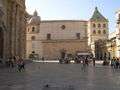
- Marsala Cathedral (17th century) dedicated to Saint Thomas of Canterbury and built on a Norman implant dated to 1176. There is an organ with 4,317 pipes.
- Church of Purgatorio.
- Church of Addolorata.
- Church of Itriella.
- Convent, church and belfry of the Carmine.
- Church of Saint Matthew.
- Church and monastery of Saint Peter.
- Church of Saint John the Baptist.
Civil architecture
- Spanish Quarters (Town Hall)
- VII April Palace (16th-17th century), built on the site of the Lodge of Pisani.
- Fici Palace.
- Grignani Palace.
- Spanò-Burgio Palace.
- Communal theatre, built in 19th Century consists in 300 seats, reopened during the 1994 and dedicated to Eliodoro Sollima.
- Cine Teatro Impero, built during Fascism.
- Agricultural Technical Institute With Specialized School Wine "Abele Damiani" Marsala - Aggregate IPSAA Strasatti With Hospitality Section (State Public top School. - (This school 13 March 2013 at Celebrated its 140th anniversary of his birth / foundation. Once l 'Institute was a monastery of the Benedictine Friars
Military architecture
- Villa Araba, Carabinieri (military police, and public security), Command Company and Operative Centre
- Castle of Marsala (formerly a State Prison up to a few years ago)
- Ancient Gates and walls of Marsala
Other
Enological establishments
Large-scale wine production started in 1773, encouraged by English trader John Woodhouse. Important winemaking establishments include Ingham-Whitaker, le Cantine Florio, Martinez, Pellegrino, Rallo, Mineo, Bianchi, Baglio Hopps, Donnafugata, Alagna, Caruso e Minini. Marsala cellars are famous not just for the production of dessert wine, but also for red and white wines. They produce modern cellar wine, such as Alcesti, De Bartoli, Fina, Vinci, Birgi, Mothia, Paolini e Baglio Oro.
Gallery
 The Main Square - "Piazza della Repubblica", still called by inhabitants "Piazza Loggia"
 Porta Garibaldi, one of the two remaining ancient gates to the old town
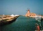 The Natural Reserve of Stagnone: salt pans and one of the wind mills close to the wharf to Mothia
 Il Cassaro (Via XI Maggio), the Main Street
 Mozia seen from coast of Marsala
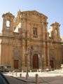 The Church of the Purgatory
References
- ↑ Diodorus Siculus, Biblioteca Historica, 23.1.2
- ↑ The New York Times, New York, Thursday, 13 May 1943
External links
| Wikimedia Commons has media related to Marsala. |
- (Italian) Official website
- Marsala 2013 - European capital of wine page (English)
- About Marsala production