Lilongwe
| Lilongwe | |
|---|---|
|
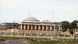
Parliament of Malawi, King's African Rifles War Memorial, Old Town | |
 Lilongwe Location of Lilongwe | |
| Coordinates: 13°59′S 33°47′E / 13.983°S 33.783°ECoordinates: 13°59′S 33°47′E / 13.983°S 33.783°E | |
| Country |
|
| Region | Central Region |
| District | Lilongwe |
| Government | |
| • Mayor | Willie Chipondera[1] |
| Elevation | 1,050 m (3,440 ft) |
| Population (2015)National Statistical Office of Malawi | |
| • Total | 1,077,116 |
| • Density | 1,479/km2 (3,830/sq mi) |
| Time zone | CAT (UTC+2) |
| Climate | Cwa |
| Website | www.llcitycouncil.org/ |

Lilongwe is the largest and capital city of Malawi with an estimated population of 1,077,116 for 2015. The city is located in the central region of Malawi, near the borders with Mozambique and Zambia, and it is an important economic and transportation hub for central Malawi.[2] It is named after the Lilongwe River.
History
Lilongwe had existed for centuries as a small fishing village on the banks of the Lilongwe River. During British Colonial Rule, the settlement became an administrative centre due to its strategic location. Formally founded in 1906[3] as a trading post, Lilongwe was officially recognised as a town in 1947.[4] After gaining independence, it increasingly developed into an important trading centre in Malawi's central region. Its growth was encouraged when the country's former head of state, Hastings Kamuzu Banda, established it as Malawi's new capital city in 1975.[5] The last government offices were relocated to Lilongwe in 2005.[6] The city's population is increasing rapidly, with an annual growth rate of 4.3%.[2]
Politics
Local Government
Lilongwe is governed by Lilongwe City Council, which is dominated by governing DPP.[1]
Demographics
| Year | Population[2][7] |
|---|---|
| 1966 | 19,425 |
| 1977 | 98,718 |
| 1987 | 223,318 |
| 1998 | 440,471 |
| 2008 | 674,448 |
| 2015 | 1,077,116 |
| 2020 (projected) | 1,324,314 |
Geography
Topography
Lilongwe is located on a plateau in Central Malawi, forming part of the East African Rift Valley situated at an altitude of 1,050 m (3,440 ft) above sea level, along Lilongwe River.
Climate
Lilongwe features a humid subtropical climate that borders on a subtropical highland climate (Köppen: Cwa), with pleasantly warm summers and mild winters. Due to the altitude, temperatures are lower than would be expected for a city located in the tropics. Lilongwe features a short wet season that runs from December to March and a lengthy dry season that covers much of the remainder of the year, particularly June and July which are cooler than the rest of the year. However, the city sees heavy downpours during its rainy season, seeing around 200 millimetres (7.9 in) of rain in a month during the wettest months.
| Climate data for Lilongwe (extremes 1981–present) | |||||||||||||
|---|---|---|---|---|---|---|---|---|---|---|---|---|---|
| Month | Jan | Feb | Mar | Apr | May | Jun | Jul | Aug | Sep | Oct | Nov | Dec | Year |
| Record high °C (°F) | 32.5 (90.5) |
31.2 (88.2) |
30.2 (86.4) |
30.5 (86.9) |
31.5 (88.7) |
28.0 (82.4) |
29.2 (84.6) |
29.5 (85.1) |
33.1 (91.6) |
34.5 (94.1) |
34.2 (93.6) |
32.4 (90.3) |
34.5 (94.1) |
| Average high °C (°F) | 24.8 (76.6) |
24.9 (76.8) |
24.7 (76.5) |
24.7 (76.5) |
23.2 (73.8) |
22.0 (71.6) |
21.4 (70.5) |
22.6 (72.7) |
25.9 (78.6) |
27.4 (81.3) |
27.3 (81.1) |
25.6 (78.1) |
24.6 (76.3) |
| Daily mean °C (°F) | 21.2 (70.2) |
21.1 (70) |
21.1 (70) |
20.2 (68.4) |
18.3 (64.9) |
16.2 (61.2) |
16.1 (61) |
17.3 (63.1) |
20.6 (69.1) |
22.4 (72.3) |
22.9 (73.2) |
21.8 (71.2) |
19.8 (67.6) |
| Average low °C (°F) | 18.2 (64.8) |
17.7 (63.9) |
17.3 (63.1) |
15.8 (60.4) |
13.1 (55.6) |
10.1 (50.2) |
9.9 (49.8) |
11.1 (52) |
13.8 (56.8) |
16.8 (62.2) |
18.5 (65.3) |
18.3 (64.9) |
15.1 (59.2) |
| Record low °C (°F) | 11.8 (53.2) |
11.7 (53.1) |
11.3 (52.3) |
8.1 (46.6) |
3.0 (37.4) |
0.5 (32.9) |
0.1 (32.2) |
1.4 (34.5) |
5.1 (41.2) |
7.9 (46.2) |
10.0 (50) |
11.8 (53.2) |
0.1 (32.2) |
| Average precipitation mm (inches) | 223 (8.78) |
187 (7.36) |
128 (5.04) |
44 (1.73) |
12 (0.47) |
1 (0.04) |
0 (0) |
0 (0) |
1 (0.04) |
10 (0.39) |
63 (2.48) |
199 (7.83) |
869 (34.21) |
| Average precipitation days (≥ 0.1 mm) | 18 | 16 | 15 | 8 | 4 | 1 | 1 | 1 | 0 | 2 | 8 | 17 | 91 |
| Average relative humidity (%) | 83 | 83 | 82 | 78 | 74 | 69 | 65 | 60 | 52 | 53 | 62 | 78 | 69 |
| Mean monthly sunshine hours | 136.4 | 144.1 | 170.5 | 213.0 | 263.5 | 243.0 | 241.8 | 263.5 | 294.0 | 282.1 | 234.0 | 139.5 | 2,625.4 |
| Mean daily sunshine hours | 4.4 | 5.1 | 5.5 | 7.1 | 8.5 | 8.1 | 7.8 | 8.5 | 9.8 | 9.1 | 7.8 | 4.5 | 7.2 |
| Source #1: Deutscher Wetterdienst[8] | |||||||||||||
| Source #2: Meteo Climat (record highs and lows)[9] | |||||||||||||
Divisions

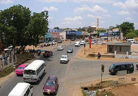
Lilongwe is divided into a New and Old City. The former hosts hotels, embassies, governmental institutions and offices while the latter has markets, bus stations, cafes and restaurants. The modern shops of the City are contrasted by the street and walled markets of Old Town.[5]
Economy
See also: Economy of Malawi
While Blantyre is the commercial Capital of Malawi, Lilongwe's economy is dominated by the government and public institutions. Kanengo District in the north of the city is the main industrial area, where food processing, tobacco storage and sales, maize storage and other light industries take place. Finance, banking, retail trade, construction, transport, public administration, tourism, and tobacco manufacturing are the main economic activities in the city. 76 percent of Lilongwe's population live in informal settlements, while poverty stands at 25 percent and unemployment at 16 percent.[6] The civil service employs about 27 percent of all formal workers, while 40 percent work in the private sector and 2 percent are self-employed.[2]
Society and culture
_-_crafts_market.JPG)
Leisure and Entertainment
A variety of bars and night clubs offer opportunities for live music and parties.[10]
Transportation

Airport
Lilongwe International Airport (LLW) is located to the north of the city.[11]
Buses
There are regular bus services from Lilongwe to Blantyre, Zomba, Kasungu and Mzuzu.[12]
Rail
There is a rail service to Lilongwe. To the west the line runs towards Zambia, and to the east to Salima.[13]
Education
There are 38 private and 66 public primary schools with a total of 103,602 pupils as well as 29 secondary schools with 30,795 students in Lilongwe.[2]
Sports
A new national stadium with a capacity of 40,000 is currently being constructed with the help of a $70 million loan from the Government of the People's Republic of China.[14]
Twin towns – Sister cities
Lilongwe is twinned with:
References
- 1 2 "DPP councillor elected Mayor of Lilongwe: Willie Chipondera, deputy Kwame Bandawe". Malawi Nyasa Times – Malawi breaking news in Malawi.
- 1 2 3 4 5 http://www.zaragoza.es/contenidos/medioambiente/onu//issue06/1136-eng.pdf
- ↑ "Lilongwe Malawi – Travel Guide – Tourist Information". wawamalawi.com.
- ↑ "Lilongwe". expertafrica.com.
- 1 2 "Lilongwe – Malawi Tourism – Malawi Safari – Malawi Attractions". malawitourism.com.
- 1 2 "Malawi Reports: Urban Profiles of Blantyre, Lilongwe, Mzuzu and Zomba". UrbanAfrica.Net.
- ↑ http://media.wix.com/ugd/672989_62cfa13ec4ba47788f78ad660489a2fa.pdf
- ↑ "Klimatafel von Lilongwe (Int. Flugh. Kamuzu) / Malawi" (PDF). Baseline climate means (1961-1990) from stations all over the world (in German). Deutscher Wetterdienst. Retrieved 10 August 2016.
- ↑ "Station Lilongwe" (in French). Météo Climat. Retrieved 14 October 2016.
- ↑ "Entertainment in Lilongwe". Lonely Planet. Retrieved 17 February 2015.
- ↑ "(LLW) Lilongwe International Airport". flightstats.com.
- ↑ "Getting there & away". Lilongwe. Lonely Planet. Retrieved 7 May 2013.
- ↑ "(Malawi Rail Map)" (PDF). Railroad Development Corporation. Retrieved 24 September 2014.
- ↑ "Malawi, China sign loan agreement to construct new stadium". Malawi Nyasa Times – Malawi breaking news in Malawi.
- ↑ "Taipei City Council". tcc.gov.tw.
- ↑ http://allafrica.com/stories/200408200493.html
- Gerke, W.J.C. & Viljoen, Charl J. Master Plan for Lilongwe the Capital City of Malawi (Johannesburg: Swan Publishing, 1968)
External links
| Wikimedia Commons has media related to Lilongwe. |
![]() Lilongwe travel guide from Wikivoyage
Lilongwe travel guide from Wikivoyage