Libyan Desert
The Libyan Desert forms the northern and eastern part of the Sahara Desert. It describes that part of the Sahara that lies within the present-day state of Libya; it also historically describes the desert to the south of Ancient Libya, a territory which lay to the east of the present-day state. The Libyan Desert is one of the driest, harshest and most remote parts of the greater Sahara, the world's largest hot desert. This extended desert country is barren, bone dry and rainless.
Geography
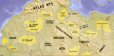
Modern Libya is divided into the regions of Cyrenaica, Tripolitania and the Fezzan. The country covers an area of 1,760,000 square kilometres (680,000 sq mi). most of which is desert save for a narrow coastal strip to the north on the shore of the Mediterranean, and the mountains of Cyrenaica (the Jebel Akhdar, or "Green Mountains").
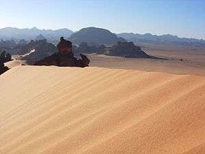
The desert covers an area of approximately 1,100,000 square kilometres (420,000 sq mi), and extends approximately 1,100 km from east to west, and 1,000 km from north to south, in about the shape of a rectangle slanting to the south-east. Like most of the Sahara, this desert is primarily sand and hamada or stony plain.
Sand plains, dunes, ridges, and some depressions (basins) typify the endorheic region, with no rivers draining into or out of the desert. The Gilf Kebir plateau reaches an altitude of just over 1,000 m, and along with the nearby massif of Jebel Uweinat is an exception to the uninterrupted territory of basement rocks covered by layers of horizontally bedded sediments, forming a massive sand plain, low plateaus, and dunes.[1]
The desert features a striking diversity of landscapes including mountains, oases, and sand seas.
To the south lie the main mountain ranges, from the Jebel Uweinat (1,980 m), on the Libya-Egypt-Sudan border, the Tibesti to the south, on the border with Chad, and the Acacus to the southwest. The main oases are Jaghbub and Jalo in east, in Cyrenaica, Kufra in the southeast, and Murzuk in the south, in Fezzan. The sand seas lie in a ring around the border of Libya. To the east lies the Calanshio Sand Sea, the western lobe of the Great Sand Sea straddling the Libya-Egypt border, and stretches 800 kilometres from Jaghbub and Jalo in the north to Kufra in the south. To the south-east lies the Rebiana Sand Sea, near the border with Sudan. To the south west is the Idehan Murzuq, bordering Chad, and to west lies the Idehan Ubari, bordering Algeria. The sand seas contain dunes up to 512 meters in height, and cover approximately one quarter of the total desert region.
Other features are the Aswad al Haruj (the "Black Desert"), a large circular region of black volcanic shield in the centre of the country, and the Hamada al Hamra (the "Red Desert") a rocky plateau to the west, on the Tunisian border, coloured by iron oxide deposits. To the southeast, between Kufra and the Libya-Egypt-Sudan border, lies the Jebel Arkenu, with the associated Arkenu structures, thought to be caused by meteorite strikes.[1] North of the Gilf Kebir plateau, among the shallow peripheral dunes of the southern Great Sand Sea, is a field of Libyan desert glass. This is thought to be associated with a meteorite impact, marked by the Kebira crater, on the Libya-Egypt border. A specimen of the desert glass was used in a piece of Tutankhamun's ancient jewellery.
The Libyan Desert is barely populated apart from the modern settlements at oases of the lower Cyrenaica region in southeastern Libya. The indigenous population are Bisharin tribe, Mahas, and Berber. Where the desert extends into Egypt and no longer in Libya, it is generally known as the "Western Desert". The term "Western Desert" contrasts with the Eastern Desert to the east of the Nile River, which lies between the Nile and the Red Sea.
Climate
The Libyan desert is said to be one of the least hospitable regions on Earth. Its climate is surprisingly variable, being hot in summer, with average daytime temperatures of 50 °C (122 °F) and above, though this drops rapidly at night. In winter days are cool, with temperastures averaging 27 °C (81 °F), but at night this can drop below freezing, with temperatures of −9 °C (16 °F) recorded. At these times the formation of hoar frost is not uncommon, and are known as "White Nights". Contrariwise, at 'Aziziya a daytime temperature of 58 °C (136 °F) was seen in 1922, the highest naturally-occurring temperature on record.[2]
In the north, along the Mediterranean shore, cool onshore winds blow inland, while further south, hot, dry winds, known as Ghibli, blow from the interior, creating blinding sand-storms.
History
Historical desert
_p_120.jpg)
Historically, "Libya" referred to an ill-defined area to the west of Ancient Egypt, whose boundary traditionally was the lake of Mareotis, outside Alexandria. The ancient Greeks, such as Herodotus, regarded the whole of the North African littoral, to Cape Spartel in Morocco, as “Libya”. Later, the Romans organized the region the provinces of Libya Inferior and Libya Superior, which covered western Egypt and Cyrenaica. Thus the "Libyan Desert" was the desert to the south of Ancient Libya. With the organization of the Italian colony of Libya in the 20th century the term "Libyan Desert" for this region became a misnomer,and the area of desert within Egypt became known as the "Western Desert" (ie west of the Nile, in contradistinction to the Eastern Desert, east of the Nile).[3]
World War I
Following the conquest of the territory by Italy during the Italo-Turkish War of 1911-12, the desert became the scene of a two-decade struggle between the Italians and the Senussi, who were centred on the Jebel Akhdar in Cyrenaica and on the Kufra oasis. It ended in 1931 with the conquest of Kufra by the Italians.
Modern exploration
During the 1930's the Libyan desert was the scene of exploration and mapping by the Italian Army and Air Force. Others, such as Ralph Bagnold and Laszlo Almasy also travelled in south-eastern Libya and southern Egypt, searching for the lost oasis of Zerzura. Bagnold also travelled into northern Chad, to the Mourdi Depression, recording his findings in his book Libyan Sands: Travel in a Dead World, which was published in 1935.
World War II
During the Second World War the north-eastern desert between El Agheila and the Egyptian border was the scene of heavy fighting between the Axis powers and the Western Allies, a period known as the Western Desert Campaign. In the deep desert saw operations by the Italian Auto-Saharan Companies, in combat with the Allied Long Range Desert Group (LRDG) and the Free French Régiment de Tirailleurs Sénégalais du Tchad (RTST). Other actions included the Siege of Giarabub (now Jaghbub), the battle of Kufra and the raid on Murzuk, all in 1941.[4]
The Calanshio Sand Sea is the site of the missing World War II aircraft "Lady Be Good". The wreck was discovered 200 km (120 mi) north of Kufra 15 years after it was reported missing in 1943.
See also
References
Further reading
- Marq de Villers, Sahara: The Life of the Great Desert (2002) ISBN 0 00 714820 8
- Pitt, Barrie: The Crucible of War: Western Desert 1941 (1980) Jonathan Cape ISBN 0 224 01771 3
External links
| Wikimedia Commons has media related to Libyan Desert. |
- The Libyan Desert at fjexpeditions.com
- Libyan Desert at African volunteer.net; retrieved 6 November 2016
- Tea in the Sahara: a road trip though the Libyan desert Sara Wheeler, The Guardian, 4 September 2013; retrieved 6 November 2016
- The complete text and photos of the discoveries of Ahmed Pasha Hassanein in the Libyan Desert, National Geographic Magazine, September 1924
Coordinates: 24°N 25°E / 24°N 25°E