Liberty Township, Trumbull County, Ohio
| Liberty Township, Trumbull County, Ohio | |
|---|---|
| Township | |
|
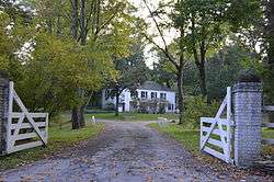
Richard Garlick House north of Youngstown | |
| Motto: "Preserving Our Heritage...Planning Our Future!" | |
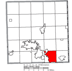 Location of Liberty Township in Trumbull County | |
| Coordinates: 41°9′25″N 80°40′40″W / 41.15694°N 80.67778°WCoordinates: 41°9′25″N 80°40′40″W / 41.15694°N 80.67778°W | |
| Country | United States |
| State | Ohio |
| County | Trumbull |
| Area | |
| • Total | 23.1 sq mi (59.9 km2) |
| • Land | 22.7 sq mi (58.9 km2) |
| • Water | 0.4 sq mi (1.0 km2) |
| Elevation[1] | 1,030 ft (314 m) |
| Population (2010) | |
| • Total | 21,982 |
| • Density | 951.6/sq mi (367.0/km2) |
| Time zone | Eastern (EST) (UTC-5) |
| • Summer (DST) | EDT (UTC-4) |
| FIPS code | 39-43344[2] |
| GNIS feature ID | 1087037[1] |
Liberty Township is one of the twenty-four townships of Trumbull County, Ohio, United States. The 2010 census found 21,982 people within the geographical area of the township, 12,034 of whom lived in the unincorporated portions of the township.[3]
Geography
Located at 41°9′25″N 80°40′40″W / 41.15694°N 80.67778°W (41.156944, -80.677778) in the southeastern part of Trumbull County, Liberty Township borders the following townships and city:
- Vienna Township, Trumbull County on the north
- Brookfield Township, Trumbull County on the northeast corner
- Hubbard Township, Trumbull County on the east
- Youngstown on the south
- Austintown Township, Mahoning County on the southwest corner
- Weathersfield Township, Trumbull County on the west
- Howland Township, Trumbull County on the northwest corner
Liberty Township is one of two urban townships in Trumbull County, along with Howland Township. It is located on the southern edge of the county.
Most of the city of Girard is located in western Liberty Township, and the census-designated place of Churchill is located in the township's center.
Demographics
According to the 2010 Census numbers, Liberty Township (the unincorporated areas, excluding the city of Girard) has 5,029 households and 3,337 families.[4]
The racial makeup of the unincorporated areas of the township is roughly 78.4% White, 17.7% Black or African American, 1.0% Asian, 0.26% American Indian or Alaska Native, 2.2% of two or more races. 2.2% identify themselves as Hispanic or Latino of any race.
Records suggest that in the township (excluding Girard), 26.1% of the households have children under the age of 18. Of households with children under the age of 18, 59.8% are married couples living together, 30.1% have a female householder with no husband present, and 2.1% are non-families. Meanwhile, 28.1% of all households comprise a single person, and 12.3% of households comprise a person over 65 years of age living alone. For every 100 females, there are 92.7 males. The median age is 46 years. The average household size is 2.35 and the average family size is 2.86.
Name and history

It is one of twenty-five Liberty Townships statewide.[5]
Liberty Township was formed from the Connecticut Western Reserve. It was established as a township in 1806. The first settler in the township was thought to be Henry Swager in 1798. Four villages grew within its borders: Girard, Churchill, Sodom, and Seceders Corners. In 1860, coal was discovered on Alexander McCleery's farm becoming a major industry in the area for the next forty years.[6]
Government
The township is governed by a three-member board of trustees, who are elected in November of odd-numbered years to a four-year term beginning on the following January 1. Two are elected in the year after the presidential election and one is elected in the year before it. There is also an elected township fiscal officer,[7] who serves a four-year term beginning on April 1 of the year after the election, which is held in November of the year before the presidential election. Vacancies in the fiscal officership or on the board of trustees are filled by the remaining trustees.
Education
Public education in the township (excluding the city of Girard) is managed by the Liberty Local School District. The school district mascot is the leopard.[8] The Liberty Township school district comprises three schools:
Average district daily enrollment during the 2010-2011 school year was 1427 pupils. 59.2% of pupils are white (non-Hispanic), 31.7% are black (non-Hispanic), 2.9% are Hispanic, and 5.3% are multiracial. 60.2% of pupils come from economically disadvantaged households. 12.2% of pupils are students with disabilities.[9]
Transportation
State Route 193 is a significant transportation artery in Liberty Township.
Notable people
- Marc Dann, former attorney general of Ohio
- Jerry DePizzo, saxophonist and guitaristist
- Bob DiPiero, songwriter
- John Q. Emery, Wisconsin Superintendent of Public Instruction
- Dave Malkoff, National Correspondent for The Weather Channel
See also
- Youngstown, Ohio is the main metropolitan area bordering Liberty Township.
References
- 1 2 "US Board on Geographic Names". United States Geological Survey. 2007-10-25. Retrieved 2008-01-31.
- ↑ "American FactFinder". United States Census Bureau. Archived from the original on September 11, 2013. Retrieved 2008-01-31.
- ↑ "2010 Census". U.S. Census Bureau. Archived from the original on September 11, 2013. Retrieved 6 January 2012.
- ↑ "2010 Census". U.S. Census Bureau. Archived from the original on September 11, 2013. Retrieved 6 January 2012.
- ↑ "Detailed map of Ohio" (PDF). United States Census Bureau. 2000. Retrieved 2007-02-16.
- ↑ "13". History of Trumbull and Mahoning Counties Vol. II. Cleveland: H.Z.Williams & Bro. 1882. p. 430.
- ↑ §503.24, §505.01, and §507.01 of the Ohio Revised Code. Accessed 4/30/2009.
- ↑ "Liberty Local Schools". Retrieved 6 January 2012.
- ↑ "Liberty Local School District". Ohio Department of Education District Report. Ohio Department of Education. Retrieved 6 January 2012.
External links
Municipalities and communities of Trumbull County, Ohio, United States | ||
|---|---|---|
| Cities | 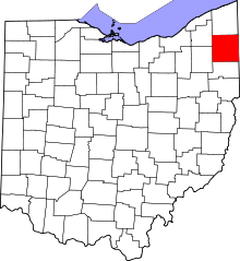 | |
| Villages | ||
| Townships | ||
| CDPs |
| |
| Unincorporated communities | ||
| Footnotes | ‡This populated place also has portions in an adjacent county or counties | |