Lhotse
| Lhotse | |
|---|---|
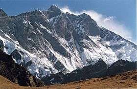 The South Face of Lhotse as seen from the climb up to Chukhung Ri. | |
| Highest point | |
| Elevation |
8,516 m (27,940 ft) [1] Ranked 4th |
| Prominence | 610 m (2,000 ft) [2] |
| Isolation | 2.66 kilometres (1.65 mi) |
| Listing | Eight-thousander |
| Coordinates | 27°57′42″N 86°56′00″E / 27.96167°N 86.93333°ECoordinates: 27°57′42″N 86°56′00″E / 27.96167°N 86.93333°E [2] |
| Geography | |
 Lhotse Location in China and Nepal border | |
| Location |
China (Tibet Autonomous Region) Nepal (Khumbu) |
| Parent range | Mahalangur Himal |
| Climbing | |
| First ascent |
May 18, 1956 Fritz Luchsinger, Ernst Reiss (First winter ascent 31 December 1988 Krzysztof Wielicki) |
| Easiest route | glacier/snow/ice climb |
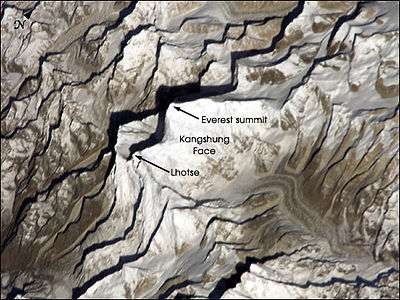
Lhotse (Nepali: ल्होत्से; Tibetan: ལྷོ་རྩེ ) is the fourth highest mountain in the world at 8,516 metres (27,940 ft), after Mount Everest, K2, and Kangchenjunga. Part of the Everest massif, Lhotse is connected to the latter peak via the South Col. Lhotse means “South Peak” in Tibetan. In addition to the main summit at 8,516 metres (27,940 ft) above sea level, the mountain comprises the smaller peaks Lhotse Middle (East) at 8,414 m (27,605 ft), and Lhotse Shar at 8,383 m (27,503 ft). The summit is on the border between China, Tibet and the Khumbu region of Nepal.
Climbing
An early attempt on Lhotse was by the 1955 International Himalayan Expedition, headed by Norman Dyhrenfurth. It also included two Austrians (cartographer Erwin Schneider and Ernst Senn) and two Swiss (Bruno Spirig and Arthur Spöhel), and was the first expedition in the Everest area to include Americans (Fred Beckey, George Bell, and Richard McGowan). The Nepalese liaison officer was Gaya Nanda Vaidya. They were accompanied by 200 local porters and several climbing Sherpas. After a brief look at the dangerous southern approaches of Lhotse Shar, they turned their attention, during September and October, to the Western Cwm and the northwest face of Lhotse, on which they achieved an altitude of about 8,100 metres (26,600 ft). They were beaten back by unexpectedly strong wind and cold temperatures. Under Schneider's direction they completed the first map of the Everest area (1:50,000 photogrammetric). The expedition also made several short films covering local cultural topics, and made a number of first ascents of smaller peaks in the Khumbu region. [3]
The main summit of Lhotse was first climbed on May 18, 1956 by the Swiss team of Ernst Reiss and Fritz Luchsinger from the Swiss Mount Everest/Lhotse Expedition.[4][5] On May 12, 1970, Sepp Mayerl and Rolf Walter of Austria made the first ascent of Lhotse Shar.[6] Lhotse Middle remained, for a long time, the highest unclimbed named point on Earth; on May 23, 2001, its first ascent was made by Eugeny Vinogradsky, Sergei Timofeev, Alexei Bolotov and Petr Kuznetsov of a Russian expedition.[7]
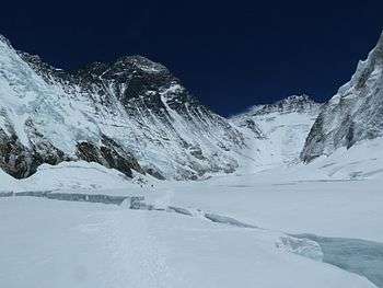
The Lhotse standard climbing route follows the same path as Everest's South Col route up to the Yellow Band beyond Camp 3. After the Yellow Band the routes diverge with climbers bound for Everest taking a left over the Geneva Spur up to the South Col, while Lhotse climbers take a right further up the Lhotse face. The last part to the summit leads through the narrow "Reiss couloir" until the Lhotse main peak is reached.
As of December 2008, 371 climbers have summitted Lhotse and 20 have died.[8]

Timeline
- 1955 Attempt by the International Himalayan Expedition.
- 1956 May 18 First ascent of the main summit: Fritz Luchsinger and Ernst Reiss.[9]
- 1965 First attempt on Lhotse Shar by a Japanese expedition - reached 8,100 m (26,570 ft).[10]
- 1970 May 12 First ascent of Lhotse Shar by an Austrian expedition, Sepp Mayerl, Rolf Walter.
- 1973 First attempt on the South Face by a Japanese expedition led by Royei Uchida.
- 1975 Attempt on the South Face by Reinhold Messner.[11]
- 1977 Second ascent of the main summit by a German expedition led by Dr. G. Schmatz.
- 1979 Ascent of the main summit by Jerzy Kukuczka without the use of supplemental oxygen.[12] His first eight-thousander, and eventually the last one to climb 20 years later.
- 1980 April 27 Attempt on Lhotse Shar by the French climber Nicolas Jaeger, last seen at 8,200 metres (26,900 ft).
- 1981 Attempt on the South Face by an Yugoslavian expedition led by Aleš Kunaver. Vanja Matijevec and Franček Knez reach the top of the Face but not the summit.[13]
- 1981 April 30 First solo ascent without the use of supplement oxygen of the main summit by Hristo Prodanov,[14][15]as part of the first Bulgarian Himalayan expedition.
- 1981 October 16 Second ascent of Lhotse Shar Switzerland, Colin Molines
- 1984 May 20/21 Members of the Czechoslovak expedition led by Ivan Galfy climb the South Face of Lhotse Shar for the first time (third overall ascent of Lhotse Shar).[13][15]
- 1986 October 16 Ascent by Reinhold Messner, thus becoming the first person to climb all of the fourteen eight-thousanders.
- 1987 May 21 the Brazilian Otto William Gerstenberger Junior and the Swiss Haans Singera reach the summit.
- 1988 December 31 Krzysztof Wielicki, a Polish climber, completed the first winter ascent of Lhotse.[16]
- 1989 October 24 Jerzy Kukuczka perishes while climbing the South Face, when his secondhand rope breaks.[17] International expedition by Reinhold Messner who turned back earlier.[11]
- 1990 April 24 Tomo Česen from Slovenia, makes first solo ascent of South Face of Lhotse.[18][19] Controversy of his climb is later raised by the USSR Himalayan expedition, claiming that his ascent would be impossible. Reinhold Messner would also raise his doubts.
- 1990 October 16 First ascent of South Face by the USSR Himalayan expedition members Sergey Bershov and Gennadiy Karataev.
- 1994 May 13 Carlos Carsolio got mountaintop solo, introducing a world speed record at 23 h 50 min rise from Base Camp to the summit.
- 1996 Chantal Mauduit becomes the first woman to reach the summit of Lhotse.
- 1997 Attempt to climb Lhotse Middle via the ridge between the main summit and Lhotse Shar by a Russian expedition, led by Vladimir Bashkirov who died in the attempt, just below the main summit.
- 1999 Attempt to climb Lhotse Middle and traverse the three summits by a Russian team, failed due to bad weather.[15]
- 2001 May 23 First ascent of Lhotse Middle by a Russian expedition.[7][15][20]
- 2007 Pemba Doma Sherpa, Nepali mountaineer and two-time summiter of Mt. Everest, falls to her death from Lhotse at 8000 m[21]
- 2011 May 14–15, Michael Horst, American guide, summits Mount Everest and Lhotse without descending below Camp IV (South Col) with less than 21 hours elapsing between the two summits.[22]
- 2011 On May 20, Indian mountaineer Arjun Vajpai became the youngest climber ever to summit Lhotse, aged 17 years, 11 months and 16 days.[23]
Lhotse Face
The western flank of Lhotse is known as the Lhotse Face. Any climber bound for the South Col on Everest must climb this 1,125 m (3,690 ft) wall of glacial blue ice. This face rises at 40 and 50 degree pitches with the occasional 80 degree bulges. High-altitude climbing Sherpas and the lead climbers will set fixed ropes up this wall of ice. Climbers and porters need to establish a good rhythm of foot placement and pulling themselves up the ropes using their jumars. Two rocky sections called the Yellow Band and the Geneva Spur interrupt the icy ascent on the upper part of the face.
On May 19, 2016 the high-altitude mountain worker Ang Furba Sherpa died when he slipped and fell down Lhotse face.[24]
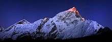
From Gokyo Ri

See also
References
- ↑ A height of 8,501 m is sometimes given but official Nepalese and Chinese mapping agree on 8,516 m.
- 1 2 "General Info". 8000ers.com. Retrieved 20 December 2009.
- ↑ Dyhrenfurth, Norman G. (1956). "Lhotse, 1955". American Alpine Journal. 10 (1): 7. Retrieved 10 April 2016.
- ↑ "The Swiss Mount Everest/Lhotse Expedition 1956". Swiss Foundation for Alpine Research. Retrieved 20 December 2009.
- ↑ Marmet, JÜRG (1957). Translated from the German by H. Adams Carter. "Everest — Lhotse, 1956". American Alpine Journal. 10 (2): 121. Retrieved 10 April 2016.
- ↑ "Lhotse Shar". old.risk.ru. Retrieved 17 January 2011.
- 1 2 Koshelenko, Yuri (2002). "Unraveling the Mystery of Lhotse Middle". American Alpine Journal. American Alpine Club. 44 (76): 166. Retrieved 10 April 2016.
- ↑ "Lhotse statistics". 8000ers.com. Retrieved 20 December 2009.
- ↑ Aargauer Zeitung, 25 April 2006
- ↑ "Asia, Nepal, Lhotse Shar: Climbs and Expeditions". American Alpine Journal. American Alpine Club. 17 (2): 434. 1971. Retrieved 8 May 2014.
- 1 2 "Ascents of Lhotse". peakbagger.com. Retrieved 28 September 2016.
- ↑ "Jerzy "Jurek" Kukuczka". everesthistory.com. Retrieved 19 August 2013.
- 1 2 Morgan, Ed (2016). Lhotse South Face- The Wall of Legends. Bee Different Books. p. 73. ISBN 978-0-9935148-0-7.
- ↑ "Christo Prodanov". everesthistory.com. Retrieved 19 August 2013.
- 1 2 3 4 "Lhotse - Historical Timeline". summitpost.org. Retrieved 28 September 2016.
- ↑ "Krzysztof Wielicki sounds off on Shisha winter climb!". mounteverest.net. Retrieved 8 May 2014.
- ↑ "Jerzy "Jurek" Kukuczka". everesthistory.com. Retrieved 8 May 2014.
- ↑ Cesen, Tomo (1991). "South Face of Lhotse, 1990". 47. The Himalayan Journal. Retrieved 8 May 2014.
- ↑ Cesen, Tomo (1991). Translated by Maja Košak. "A Look into the Future, Lhotse's South Face". American Alpine Journal. American Alpine Club. 33 (65): 1. Retrieved 10 April 2016.
- ↑ "Lhotse Middle (8414 m)". russianclimb.com. Retrieved 28 September 2016.
- ↑ "Famous female Nepal climber dead". BBC News. May 23, 2007. Retrieved 2009-12-20.
- ↑ "Everest and Lhotse in Less Than 21 Hours". Climbing.com. Archived from the original on 2011-09-20. Retrieved 16 October 2011.
- ↑ "Young Indian mountaineer scales Mt Lhotse". The Times of India. 20 May 2011. Retrieved 19 August 2013.
- ↑ Over 200 summitting Mount Everest today; a Sherpa guide dies Published: May 19, 2016 12:50 pm
Further reading
- Reiss, Ernst (1959). Mein Weg als Bergsteiger (in German). Frauenfeld, Huber. OCLC 52217934.
- A. Arnette : Lhotse gaining attention (2014)
- E. Morgan: Lhotse South Face - The Wall of Legends (2016)
External links
| Wikimedia Commons has media related to Lhotse. |
- Lhotse page on Himalaya-Info.org (German)
- Lhotse page on Summitpost
- Lhotse on Peakware
- gonomad.com, Hiking by Lhotse and Everest, feature article
- Ascents and fatalities statistics