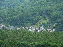
Lez, Haute-Garonne
For other uses, see LEZ.
| Lez | |
|---|---|
 | |
 Lez | |
|
Location within Occitanie region  Lez | |
| Coordinates: 42°54′36″N 0°42′06″E / 42.91°N 0.7017°ECoordinates: 42°54′36″N 0°42′06″E / 42.91°N 0.7017°E | |
| Country | France |
| Region | Occitanie |
| Department | Haute-Garonne |
| Arrondissement | Saint-Gaudens |
| Canton | Saint-Béat |
| Intercommunality | Canton de Saint-Béat |
| Government | |
| • Mayor (2008–2014) | Marie Crouzet |
| Area1 | 2.6 km2 (1.0 sq mi) |
| Population (2008)2 | 60 |
| • Density | 23/km2 (60/sq mi) |
| Time zone | CET (UTC+1) |
| • Summer (DST) | CEST (UTC+2) |
| INSEE/Postal code | 31298 / 31440 |
| Elevation |
499–1,180 m (1,637–3,871 ft) (avg. 505 m or 1,657 ft) |
|
1 French Land Register data, which excludes lakes, ponds, glaciers > 1 km² (0.386 sq mi or 247 acres) and river estuaries. 2 Population without double counting: residents of multiple communes (e.g., students and military personnel) only counted once. | |
Lez is a commune in the Haute-Garonne department in southwestern France.
Population
| Historical population | ||
|---|---|---|
| Year | Pop. | ±% |
| 1962 | 135 | — |
| 1968 | 154 | +14.1% |
| 1975 | 110 | −28.6% |
| 1982 | 75 | −31.8% |
| 1990 | 72 | −4.0% |
| 1999 | 67 | −6.9% |
| 2008 | 60 | −10.4% |
See also
References
| Wikimedia Commons has media related to Lez (Haute-Garonne). |
This article is issued from Wikipedia - version of the 3/21/2014. The text is available under the Creative Commons Attribution/Share Alike but additional terms may apply for the media files.