Lexington Battle Green
|
Lexington Green | |
|
The Revolutionary Monument 1799 | |
| Location | Massachusetts Avenue and Harrington Road, Lexington, Massachusetts |
|---|---|
| Coordinates | 42°26′58″N 71°13′53″W / 42.44944°N 71.23139°WCoordinates: 42°26′58″N 71°13′53″W / 42.44944°N 71.23139°W |
| Built | 1711 |
| NRHP Reference # | 66000767[1] |
| Significant dates | |
| Added to NRHP | October 15, 1966 |
| Designated NHL | January 20, 1961 |

The Lexington Battle Green, properly known as Lexington Common, is the historic town common of Lexington, Massachusetts. It was at this site that the opening shots of the Battles of Lexington and Concord were fired on April 19, 1775, starting the American Revolutionary War. Now a public park, the common is a National Historic Landmark.
History
Unlike many other towns, Lexington did not set aside a separate common area when the town was laid out. In 1711, the townspeople raised funds by subscription, and purchased 1.5 acres (0.61 ha) of land as a militia training ground. This was enlarged by one more acre in 1722. The common is a triangular parcel of land, bounded by Massachusetts Avenue, Bedford Street, and Harrington Road, and is located just northwest of Lexington's commercial center. The Buckman Tavern, one of the area's busiest local taverns, stands across Bedford Street; it is also a National Historic Landmark.
On April 19, 1775, local militiamen emerged from Buckman Tavern adjacent to the common and formed two rows on the common to face arriving British troops. The militiamen suffered the first casualties of the American Revolution when the two sides exchanged fire.
Description
The battle green, now a public park, is a grassy expanse with a few mature trees. There are several memorials on the fringes of the common, the most iconic being the statue representing Captain John Parker, the leader of the Lexington militia, which stands at its eastern corner. It was erected in 1900 at the bequest of Francis Brown Hayes, and was sculpted by well-known Massachusetts artist Henry Hudson Kitson. A bronze plaque, placed in 1910 by the Daughters of the American Revolution, marks the original location of the Old Belfry. The Belfry was moved several times before being destroyed by a gale in 1909. It was rebuilt the following year and is now located on a hill just south of the park. Near the western corner of the park stands what is considered the oldest memorial to the Revolution: the Revolutionary War Monument, a granite obelisk erected in 1799. In 1835, the remains of seven of the eight miltiamen killed in the battle were exhumed from the nearby Old Burying Ground and reburied within the monument's iron fence. The monument also marks the approximate western end of the Patriot line. The line's eastern end is marked with an inscribed boulder.[2]
The battle green is one of only eight locations in the United States[3] where the U.S. flag is specifically authorized by law to fly twenty-four hours a day,[4] though the U.S. Flag Code (4 U.S.C. §4-10) allows for the flag to be displayed anywhere "24 hours a day if properly illuminated during the hours of darkness."[5]
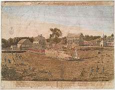 Amos Doolittle's engraving of the Skirmish at Lexington; the Buckman Tavern is building # 6 left of the tree at center
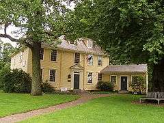 Buckman Tavern
.jpg) The Green in modern times
The Green in modern times Inscription on the Revolutionary monument
_-_Lexington%2C_MA.JPG) Lexington Minutemen relief by Bashka Paeff
Lexington Minutemen relief by Bashka Paeff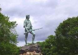 The Minuteman Statue, 1900
See also
- List of National Historic Landmarks in Massachusetts
- National Register of Historic Places listings in Middlesex County, Massachusetts
- Hancock-Clarke House, another nearby National Historic Landmark
References
- ↑ National Park Service (2007-01-23). "National Register Information System". National Register of Historic Places. National Park Service.
- ↑ "NHL nomination for Lexington Green" (PDF). National Park Service. Retrieved 2014-04-07.
- ↑ Luckey, John R. "The United States Flag: Federal Law Relating to Display and Associated Questions". United States Senate. Congressional Research Service. Retrieved 8 April 2015.
- ↑ "U.S. Public Law 89-335--Nov. 8, 1965 79 Stat. 1294" (PDF).
- ↑ "United States Code (2011)" (PDF). U.S. Government Publishing Office. GPO. Retrieved 8 April 2015.
External links
-
 Media related to Lexington Battle Green at Wikimedia Commons
 - Battle Green
| Topics |  | ||||||||||||||||||||||||||||||
|---|---|---|---|---|---|---|---|---|---|---|---|---|---|---|---|---|---|---|---|---|---|---|---|---|---|---|---|---|---|---|---|
| Lists by county | |||||||||||||||||||||||||||||||
| Lists by city |
| ||||||||||||||||||||||||||||||
| Other lists | |||||||||||||||||||||||||||||||
| |||||||||||||||||||||||||||||||