Lexington Avenue
|
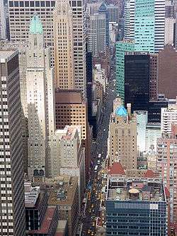
View northward from the top floors of the Chrysler Building | |
| Other name(s) | Irving Place |
|---|---|
| Maintained by | NYCDOT |
| Length | 5.8 mi[1][2] (9.3 km) |
| Location | Manhattan, New York City |
| South end | 14th Street in Gramercy Park |
| Major junctions | Third Avenue Bridge in East Harlem |
| North end | 131st Street in East Harlem |
| East | Third Avenue |
| West | Park Avenue |
| Construction | |
| Commissioned | 1832 |
| Completion | 1836 |
Lexington Avenue, often colloquially abbreviated as "Lex," is an avenue on the East Side of the borough of Manhattan in New York City that carries southbound one-way traffic from East 131st Street to Gramercy Park at East 21st Street. Along its 5.5-mile (8.9-kilometer), 110-block route, Lexington Avenue runs through Harlem, Carnegie Hill, the Upper East Side, Midtown, and Murray Hill to a point of origin that is centered on Gramercy Park. South of Gramercy Park, the axis continues as Irving Place from 20th Street to East 14th Street.
Lexington Avenue was not one of the streets included in the Commissioners' Plan of 1811 street grid, so the addresses for cross streets do not start at an even hundred number, as they do with avenues that were originally part of the plan.
The portion of Lexington Avenue between 14th and 20th Streets is known as Irving Place.
History
Both Lexington Avenue and Irving Place began in 1832 when Samuel Ruggles, a lawyer and real-estate developer, petitioned the New York State Legislature to approve the creation of a new north/south avenue between the existing Third and Fourth Avenues, between 14th and 30th Streets. Ruggles had purchased land in the area, and was developing it as a planned community of townhouses around a private park, which he called Gramercy Park. He was also developing property around the planned Union Square, and wanted the new road to improve the value of these tracts. The legislation approved, and, as the owner of most of the land along the route of the new street, Ruggles was assessed for the majority of its cost. Ruggles named the southern section, below 20th Street, which opened in 1833, after his friend Washington Irving. The northern section, which opened three years later, in 1836, was named after the Battle of Lexington in the Revolutionary War.[3][4]
In 1899, Lexington would see the first arrest in New York for speeding, when a bicycle patrolman overtook cabdriver Jacob German, who had been racing down the avenue at the "reckless" speed of 12 mph (19 km/h).[5] The portion of Lexington Avenue above East 42nd Street was reconstructed at the same time as the IRT Lexington Avenue Line of the New York City Subway. The widened street and the subway line both opened on July 17, 1918.[6]
Parallel to Lexington Avenue lies Park Avenue to its west and Third Avenue to its east. The avenue is largely commercial at ground level, with offices above. There are clusters of hotels in the 30s and 40s, roughly from the avenue's intersection with 30th Street through to its intersection with 49th Street, and apartment buildings farther north.
In 1955, portions of the avenue were widened, which required eminent domain takings of the facades of some structures along Lexington.[7]
Lexington Avenue has carried one-way (downtown) traffic since July 17, 1960.[8]
The July 18, 2007 New York City steam explosion sent a geyser of hot steam up from beneath the avenue at 41st Street resulting in one death and more than 40 injuries.
Irving Place
In contrast to Lexington Avenue, the five-block stretch of Irving Place, from 14th to 20th Street at Gramercy Park carries two-way traffic and is decidedly local in nature. After the opening of Union Square in 1839, the Irving Place area became one of the most sought-after residential neighborhoods in the city, a situation which was only enhanced by the development of Gramercy Park to the north and Stuyvesant Square to the east.[4]
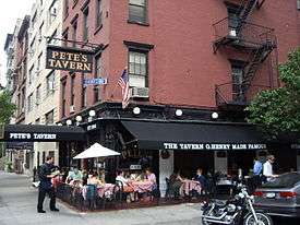
An assortment of restaurants and bars line Irving Place, including Pete's Tavern, New York's oldest surviving saloon, where O. Henry supposedly conceived of "The Gift of the Magi", and which survived Prohibition disguised as a flower shop. Irving Plaza, on East 15th Street and Irving, hosts numerous concerts for both well-known and indie bands and draws a crowd almost every night. Another component of the avenue are the large apartment buildings which line the street from Gramercy Park to 17th Street. Also at 17th, a small bed-and-breakfast, the Inn at Irving Place, occupies two Greek Revival architecture townhouses built in 1840–1841 and renovated in 1991–1995.
Historically and architecturally significant are 47 and 49 Irving Place – the latter where Washington Irving is said to have lived, but did not[4] – which are part of the East 17th Street/Irving Place Historic District, and 19 Gramercy Park on the corner of 20th Street, part of the Gramercy Park Historic District.
Offices located on Irving Place include those of The Nation magazine, the New York branch of the Rosicrucian Order and the Seafarers and International House mission.[9] There are also a number of clinics and official city buildings along the street, including Washington Irving High School and the headquarters of the New York City Human Resources Administration.[9] The bottom of the street is anchored by the rear of the Zeckendorf Towers condominium apartment complex on the west side, and the Consolidated Edison Building on the east.[9]
Public transportation
Surface:
The following buses use Lexington Avenue between the following streets (northbound buses run along Third Avenue):
- M98: Between East 120th and East 67th Streets
- M101, M102, M103 (Third and Lexington Avenues Line): Between Harlem and East 24th Streets; turns east at East 24th Street. M101 and M103 run to 125th Street; M102 runs to 116th Street and turns west there.
- BxM1: Between East 106th and East 34th Streets
Subway:
The IRT Lexington Avenue Line (4 5 6 <6> trains) of the New York City Subway runs under Lexington Avenue north of 42nd Street (at Grand Central) to 125th Street; south of Grand Central, this subway line runs under Park Avenue, Park Avenue South, and Fourth Avenue until Astor Place.
In popular culture
Lexington Avenue became part of a classic American cinematic moment, in the 1955 movie The Seven Year Itch, the scene in which Marilyn Monroe shot what would become her most famous scene. Standing on a subway grating outside the Loew's Lexington theatre, her skirt billows up from the wind underneath. While the footage showing the theatre in the background appeared in the finished film, the footage featuring the subway grate shot on September 15, 1954, on the corner of Lexington Avenue and 51st Street was more of a publicity stunt, retakes were shot on a studio soundstage, and shots from both are seen in the film.[10]
See also
- Lexington Avenue bombing
- Indian Cuisine: in reference to the growing number of Asian Indian restaurants and spice shops along a stretch of Lexington Avenue between 25th and 30th Streets in the Rose Hill neighborhood which has become known as Curry Hill.[11]
References
Notes
- ↑ Google (September 10, 2015). "Lexington Avenue" (Map). Google Maps. Google. Retrieved September 10, 2015.
- ↑ Google (September 10, 2015). "Irving Place" (Map). Google Maps. Google. Retrieved September 10, 2015.
- ↑ Henry Moscow:The Street Book. New York: Fordham University Press 1978. p.69.
- 1 2 3 Harris, Gale and Shockley, Jay. "East 17th Street/Irving Place Historic District Designation Report" New York City Landmarks Preservation Commission (June 30, 1988)
- ↑ Lewis, Mary Beth. "Ten Best First Facts", in Car and Driver, 1/88, p. 92.
- ↑ Cunningham, Joseph and DeHart, Leonard: A History of the New York City Subway System, 1993. p. 51
- ↑ "Congregation Orach Chaim History".
- ↑ Spiegel, Irving (July 18, 1960). "2 One-Way Shifts Go Smoothly". The New York Times. Retrieved August 28, 2012.
- 1 2 3 "Lexington Avenue an Irving Place" on New York City Songlines
- ↑ "Marilyn" Essay by George S. Zimbel. Montreal, July 2000.
- ↑ Kris Ensminger (October 10, 2008). "Good Eating Curry Hill More Than Tandoori". The New York Times. Retrieved February 8, 2014.
Further reading
External links
| Wikimedia Commons has media related to |
- New York Songlines: Lexington Avenue with Irving Place, a virtual walking tour