Lewis and Clark Lake
| Lewis and Clark Lake | |
|---|---|
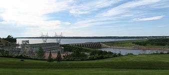 Lewis and Clark Lake behind Gavins Point Dam | |
| Location | South Dakota / Nebraska |
| Coordinates | 42°51′45″N 97°29′30″W / 42.8625°N 97.4917°WCoordinates: 42°51′45″N 97°29′30″W / 42.8625°N 97.4917°W |
| Type | reservoir |
| Primary inflows | Missouri River |
| Primary outflows | Missouri River |
| Basin countries | United States |
| Max. length | 25 miles (40 km) |
| Surface area | 31,000 acres (13,000 ha) |
| Max. depth | 45 ft (14 m) |
| Water volume | 492,000 acre·ft (0.607 km3)[1] |
Lewis and Clark Lake is an impoundment on the Missouri River above Gavins Point Dam, near Yankton, South Dakota. It is located on the border of South Dakota and Nebraska. The reservoir is approximately 25 miles (40 km) long, with a surface area of 31,000 acres (130 km²); it has a maximum depth of 45 feet (14 m). It is the smallest of the Pick-Sloan Plan impoundments, and has been plagued with siltation problems. Lewis and Clark Lake (with Gavins Point Dam) is a very popular for camping as a regional tourist destination, having hosted over one million visitors per year.
See also
External links
References
- ↑ "Gavins Point Dam & Power Plant". United States Army Corps of Engineers. Retrieved 2010-04-26.
This article is issued from Wikipedia - version of the 7/14/2016. The text is available under the Creative Commons Attribution/Share Alike but additional terms may apply for the media files.