Lewis County, Missouri
| Lewis County, Missouri | |
|---|---|
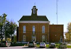 Lewis County Courthouse in Monticello | |
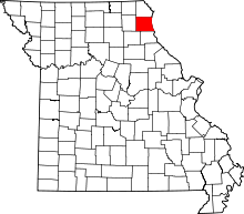 Location in the U.S. state of Missouri | |
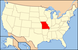 Missouri's location in the U.S. | |
| Founded | January 2, 1833 |
| Named for | Meriwether Lewis |
| Seat | Monticello |
| Largest city | Canton |
| Area | |
| • Total | 511 sq mi (1,323 km2) |
| • Land | 505 sq mi (1,308 km2) |
| • Water | 5.8 sq mi (15 km2), 1.1% |
| Population (est.) | |
| • (2015) | 10,207 |
| • Density | 20/sq mi (8/km²) |
| Congressional district | 6th |
| Time zone | Central: UTC-6/-5 |
| Website |
lewiscountymo |
Lewis County is a county located in the northeastern portion of the U.S. state of Missouri. As of the 2010 census, the population was 10,211.[1] Its county seat is Monticello.[2] The county was organized January 2, 1833 and named for Meriwether Lewis, the explorer and Governor of the Louisiana Territory.[3]
Lewis County is part of the Quincy, IL–MO Micropolitan Statistical Area.
Geography
According to the U.S. Census Bureau, the county has a total area of 511 square miles (1,320 km2), of which 505 square miles (1,310 km2) is land and 5.8 square miles (15 km2) (1.1%) is water.[4]
Adjacent counties
- Clark County (north)
- Hancock County, Illinois (northeast)
- Adams County, Illinois (southeast)
- Marion County (south)
- Shelby County (southwest)
- Knox County (west)
Major highways
Demographics
| Historical population | |||
|---|---|---|---|
| Census | Pop. | %± | |
| 1840 | 6,040 | — | |
| 1850 | 6,578 | 8.9% | |
| 1860 | 12,286 | 86.8% | |
| 1870 | 15,114 | 23.0% | |
| 1880 | 15,925 | 5.4% | |
| 1890 | 15,935 | 0.1% | |
| 1900 | 16,724 | 5.0% | |
| 1910 | 15,514 | −7.2% | |
| 1920 | 13,465 | −13.2% | |
| 1930 | 12,093 | −10.2% | |
| 1940 | 11,490 | −5.0% | |
| 1950 | 10,733 | −6.6% | |
| 1960 | 10,984 | 2.3% | |
| 1970 | 10,993 | 0.1% | |
| 1980 | 10,901 | −0.8% | |
| 1990 | 10,233 | −6.1% | |
| 2000 | 10,494 | 2.6% | |
| 2010 | 10,211 | −2.7% | |
| Est. 2015 | 10,207 | [5] | 0.0% |
| U.S. Decennial Census[6] 1790-1960[7] 1900-1990[8] 1990-2000[9] 2010-2015[1] | |||
As of the census[10] of 2010, there were 10,211 people, 3,956 households, and 2,709 families residing in the county. The population density was 21 people per square mile. The racial makeup of the county was 95.92% White, 2.53% Black or African American, 0.16% Native American, 0.20% Asian, 0.02% Pacific Islander, 0.44% from other races, and 0.73% from two or more races. Approximately 0.73% of the population were Hispanic or Latino of any race. 34.9% were of German, 18.3% American, 11.2% English and 10.8% Irish ancestry.
The average household size was 2.46 and the average family size was 3.00. In the county the population was spread out with 25.00% under the age of 18, 12.90% from 18 to 24, 24.60% from 25 to 44, 21.40% from 45 to 64, and 16.10% who are 65 years of age or older and 51% of female population. The median age is 36 years.
Median income for a household in the county is $30,651, and the median income for a family was $35,740. Males had a median income of $27,778 versus $19,679 for females. The per capita income for the county was $14,746. 16.10% of the population and 10.70% of families were below the poverty line.
Education
Public schools
- Canton R-V School District – Canton
- Canton Elementary School (PK-06)
- Canton High School (07-12)
- Lewis County C-1 School District – Ewing
- Highland Elementary School (K-06)
- Highland Junior-Senior High School (07-12)
Private schools
- Cedar Falls School – Canton (K-12) – Nonsectarian
Post-secondary
- Culver-Stockton College – Canton – A private, four-year Christian Church (Disciples of Christ) university.
Politics
Local
The Democratic Party predominantly controls politics at the local level in Lewis County. Democrats hold all but one of the elected positions in the county.
| Lewis County, Missouri | ||||
|---|---|---|---|---|
| Elected countywide officials | ||||
| Assessor | Craig Myers | Democratic | ||
| Circuit Clerk | Jan E. Geisendorfer | Democratic | ||
| County Clerk | Sharon Schlager | Democratic | ||
| Collector | Robert E. (Bob) Veatch | Democratic | ||
| Commissioner (Presiding) |
Wayne Murphy, Jr. | Republican | ||
| Commissioner (District 1) |
John Campen | Democratic | ||
| Commissioner (District 2) |
Jesse Roberts | Democratic | ||
| Coroner | Larry Arnold | Democratic | ||
| Prosecuting Attorney | Jules V. (Jake) DeCoster | Democratic | ||
| Public Administrator | Brett B. Bozarth | Democratic | ||
| Recorder | Brenda Gunlock | Democratic | ||
| Sheriff | David T. Parrish | Democratic | ||
| Surveyor | Jason D. Janes | Democratic | ||
| Treasurer | Kim Porter | Democratic | ||
State
| Year | Republican | Democratic | Third Parties |
|---|---|---|---|
| 2012 | 48.24% 2,046 | 49.54% 2,101 | 2.22% 94 |
| 2008 | 56.79% 2,533 | 41.05% 1,831 | 2.16% 96 |
| 2004 | 67.03% 3,084 | 31.32% 1,441 | 1.65% 76 |
| 2000 | 50.03% 2,224 | 48.46% 2,154 | 1.51% 67 |
| 1996 | 22.77% 948 | 75.23% 3,132 | 1.99% 83 |
All of Lewis County is included in Missouri’s 4th District in the Missouri House of Representatives and is represented by Craig Redmon (R-Canton).
| Party | Candidate | Votes | % | ± | |
|---|---|---|---|---|---|
| Republican | Craig Redmon | 2,450 | 100.00 | ||
| Party | Candidate | Votes | % | ± | |
|---|---|---|---|---|---|
| Republican | Craig Redmon | 3,869 | 100.00 | ||
All of Lewis County is a part of Missouri’s 18th District in the Missouri Senate and is currently represented by Brian Munzlinger (R-Williamstown).
| Party | Candidate | Votes | % | ± | |
|---|---|---|---|---|---|
| Republican | Brian Munzlinger | 2,363 | 100.00 | +31.70 | |
| Party | Candidate | Votes | % | ± | |
|---|---|---|---|---|---|
| Republican | Brian Munzlinger | 2,353 | 68.30 | ||
| Democratic | Wes Shoemyer | 1,092 | 31.70 | ||
Federal
| Party | Candidate | Votes | % | ± | |
|---|---|---|---|---|---|
| Democratic | Claire McCaskill | 2,093 | 49.57 | ||
| Republican | Todd Akin | 1,982 | 46.95 | ||
| Libertarian | Jonathan Dine | 147 | 3.48 | ||
All of Lewis County is included in Missouri’s 6th Congressional District and is currently represented by Sam Graves (R-Tarkio) in the U.S. House of Representatives.
| Party | Candidate | Votes | % | ± | |
|---|---|---|---|---|---|
| Republican | Sam Graves | 1,822 | 71.10 | +7.09 | |
| Democratic | Bill Hedge | 697 | 26.33 | -7.28 | |
| Libertarian | Russ Monchil | 68 | 2.57 | +0.20 | |
| Party | Candidate | Votes | % | ± | |
|---|---|---|---|---|---|
| Republican | Sam Graves | 2,588 | 64.01 | ||
| Democratic | Kyle Yarber | 1,359 | 33.61 | ||
| Libertarian | Russ Monchil | 96 | 2.37 | ||
| Year | Republican | Democratic | Third Parties |
|---|---|---|---|
| 2012 | 62.56% 2,677 | 35.24% 1,508 | 2.20% 94 |
| 2008 | 57.62% 2,594 | 40.80% 1,837 | 1.58% 71 |
| 2004 | 61.63% 2,862 | 37.77% 1,754 | 0.60% 28 |
| 2000 | 53.26% 2,388 | 45.12% 2,023 | 1.62% 73 |
| 1996 | 34.79% 1,453 | 49.09% 2,050 | 16.12% 673 |
Missouri Presidential Preference Primary (2008)
- Former U.S. Senator Hillary Clinton (D-New York) received more votes, a total of 619, than any candidate from either party in Lewis County during the 2008 presidential primary.
| Lewis County, Missouri | ||
|---|---|---|
| 2008 Republican primary in Missouri | ||
| John McCain | 279 (34.23%) | |
| Mike Huckabee | 286 (35.09%) | |
| Mitt Romney | 197 (24.17%) | |
| Ron Paul | 32 (3.93%) | |
| Lewis County, Missouri | ||
|---|---|---|
| 2008 Democratic primary in Missouri | ||
| Hillary Clinton | 619 (53.50%) | |
| Barack Obama | 476 (41.14%) | |
| John Edwards (withdrawn) | 44 (3.80%) | |
| Uncommitted | 11 (0.95%) | |
Communities
- Canton
- Durham
- Ewing
- La Belle
- La Grange
- Lewistown
- Maywood
- Monticello (county seat)
- Steffenville
- Williamstown
See also
References
- 1 2 "State & County QuickFacts". United States Census Bureau. Retrieved September 10, 2013.
- ↑ "Find a County". National Association of Counties. Retrieved 2011-06-07.
- ↑ Eaton, David Wolfe (1916). How Missouri Counties, Towns and Streams Were Named. The State Historical Society of Missouri. p. 185.
- ↑ "2010 Census Gazetteer Files". United States Census Bureau. August 22, 2012. Retrieved November 16, 2014.
- ↑ "County Totals Dataset: Population, Population Change and Estimated Components of Population Change: April 1, 2010 to July 1, 2015". Retrieved July 2, 2016.
- ↑ "U.S. Decennial Census". United States Census Bureau. Retrieved November 16, 2014.
- ↑ "Historical Census Browser". University of Virginia Library. Retrieved November 16, 2014.
- ↑ "Population of Counties by Decennial Census: 1900 to 1990". United States Census Bureau. Retrieved November 16, 2014.
- ↑ "Census 2000 PHC-T-4. Ranking Tables for Counties: 1990 and 2000" (PDF). United States Census Bureau. Retrieved November 16, 2014.
- ↑ "American FactFinder". United States Census Bureau. Retrieved 2008-01-31.
External links
- Lewis County website (provided by University of Missouri Extension)
- Digitized 1930 Plat Book of Lewis County from University of Missouri Division of Special Collections, Archives, and Rare Books
 |
Clark County | Hancock County, Illinois | | |
| Knox County | |
|||
| ||||
| | ||||
| Shelby County | Marion County | Adams County, Illinois |
Municipalities and communities of Lewis County, Missouri, United States | ||
|---|---|---|
| Cities | | |
| Village | ||
| Townships | ||
| Unincorporated communities | ||
| Ghost town | ||
Coordinates: 40°05′N 91°44′W / 40.09°N 91.73°W