Lewis County, Idaho
| Lewis County, Idaho | ||
|---|---|---|
| ||
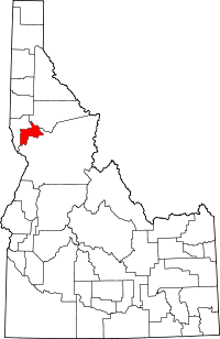 Location in the U.S. state of Idaho | ||
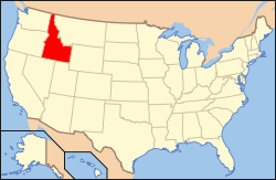 Idaho's location in the U.S. | ||
| Founded | March 3, 1911 | |
| Named for | Meriwether Lewis | |
| Seat | Nezperce | |
| Largest city | Kamiah | |
| Area | ||
| • Total | 480 sq mi (1,243 km2) | |
| • Land | 479 sq mi (1,241 km2) | |
| • Water | 0.9 sq mi (2 km2), 0.2% | |
| Population | ||
| • (2010) | 3,821 | |
| • Density | 8.0/sq mi (3/km²) | |
| Congressional district | 1st | |
| Time zone | Pacific: UTC-8/-7 | |
| Website |
lewiscountyid | |

Lewis County is a county located in the north central region of the U.S. state of Idaho. As of the 2010 census, the population was 3,821,[1] making it the fourth-least populous county in Idaho. The county seat is Nezperce,[2] and Kamiah is the largest city. Partitioned from Nez Perce County and established in 1911,[3] it was named after the explorer Meriwether Lewis.
Most of the county is within the Nez Perce Indian Reservation, though Native Americans comprise less than 6% of the county population.[1] Similar to the opening of lands in Oklahoma, the U.S. government opened the reservation for white settlement in November 1895. The proclamation had been signed less than two weeks earlier by President Cleveland.[4][5][6][7]
Geography
According to the U.S. Census Bureau, the county has a total area of 480 square miles (1,200 km2), of which 479 square miles (1,240 km2) is land and 0.9 square miles (2.3 km2) (0.2%) is water.[8] It is the fourth-smallest county in Idaho by area. The county contains the northern portion of the Camas Prairie, an elevated prairie-like region of the middle Columbia basin, south of the Clearwater River. The Clearwater River forms the eastern boundary of Lewis County, just upstream of where the Lewis and Clark Expedition put their canoes in the water for the trip to the Pacific Ocean.
Adjacent counties
- Nez Perce County – northwest
- Idaho County – southeast
- Clearwater County – northeast
Major highways
National protected area
- Clearwater National Forest (part)
Demographics
| Historical population | |||
|---|---|---|---|
| Census | Pop. | %± | |
| 1920 | 5,851 | — | |
| 1930 | 5,238 | −10.5% | |
| 1940 | 4,666 | −10.9% | |
| 1950 | 4,208 | −9.8% | |
| 1960 | 4,423 | 5.1% | |
| 1970 | 3,867 | −12.6% | |
| 1980 | 4,118 | 6.5% | |
| 1990 | 3,516 | −14.6% | |
| 2000 | 3,747 | 6.6% | |
| 2010 | 3,821 | 2.0% | |
| Est. 2015 | 3,789 | [9] | −0.8% |
| U.S. Decennial Census[10] 1790–1960[11] 1900–1990[12] 1990–2000[13] 2010–2013[1] | |||
2000 census
As of the census[14] of 2000, there were 3,747 people, 1,554 households, and 1,050 families residing in the county. The population density was 8 people per square mile (3/km²). There were 1,795 housing units at an average density of 4 per square mile (1/km²). The racial makeup of the county was 92.21% White, 0.35% Black or African American, 3.84% Native American, 0.43% Asian, 0.08% Pacific Islander, 0.93% from other races, and 2.16% from two or more races. 1.89% of the population were Hispanic or Latino of any race. 30.6% were of German, 17.5% American, 10.6% English and 8.7% Irish ancestry according to Census 2000.
There were 1,554 households out of which 27.50% had children under the age of 18 living with them, 57.80% were married couples living together, and 32.40% were non-families. 28.10% of all households were made up of individuals and 14.50% had someone living alone who was 65 years of age or older. The average household size was 2.39 and the average family size was 2.92.
In the county the population was spread out with 25.40% under the age of 18, 5.30% from 18 to 24, 23.80% from 25 to 44, 27.10% from 45 to 64, and 18.50% who were 65 years of age or older. The median age was 42 years. For every 100 females there were 101.90 males. For every 100 females age 18 and over, there were 98.20 males.
The median income for a household in the county was $31,413, and the median income for a family was $37,336. Males had a median income of $31,021 versus $22,538 for females. The per capita income for the county was $15,942. About 8.70% of families and 12.00% of the population were below the poverty line, including 12.90% of those under age 18 and 9.00% of those age 65 or over.
2010 census
As of the 2010 United States Census, there were 3,821 people, 1,657 households, and 1,041 families residing in the county.[15] The population density was 8.0 inhabitants per square mile (3.1/km2). There were 1,880 housing units at an average density of 3.9 per square mile (1.5/km2).[16] The racial makeup of the county was 90.3% white, 4.7% American Indian, 0.4% black or African American, 0.4% Asian, 0.1% Pacific islander, 1.6% from other races, and 2.4% from two or more races. Those of Hispanic or Latino origin made up 3.3% of the population.[15] In terms of ancestry, 39.4% were German, 16.7% were English, 16.5% were Irish, and 3.0% were American.[17]
Of the 1,657 households, 24.8% had children under the age of 18 living with them, 50.8% were married couples living together, 7.6% had a female householder with no husband present, 37.2% were non-families, and 32.6% of all households were made up of individuals. The average household size was 2.26 and the average family size was 2.84. The median age was 48.0 years.[15]
The median income for a household in the county was $35,808 and the median income for a family was $41,250. Males had a median income of $32,933 versus $23,850 for females. The per capita income for the county was $18,580. About 10.4% of families and 16.0% of the population were below the poverty line, including 30.1% of those under age 18 and 7.2% of those age 65 or over.[18]
Communities
Cities
Unincorporated communities
See also
References
- 1 2 3 "State & County QuickFacts". United States Census Bureau. Retrieved July 1, 2014.
- ↑ "Find a County". National Association of Counties. Retrieved 2011-06-07.
- ↑ "Lewis County one of state's youngest, and richest". Lewiston Morning Tribune. October 5, 1955. p. 11.
- ↑ Hamilton, Ladd (June 25, 1961). "Heads were popping up all over the place". Lewiston Morning Tribune. p. 14.
- ↑ Brammer, Rhonda (July 24, 1977). "Unruly mobs dashed to grab land when reservation opened". Lewiston Morning Tribune. p. 6E.
- ↑ "3,000 took part in "sneak" when Nez Perce Reservation was opened". Lewiston Morning Tribune. November 19, 1931. p. 3.
- ↑ "Nez Perce Reservation". Spokesman-Review. December 11, 1921. p. 5.
- ↑ "US Gazetteer files: 2010, 2000, and 1990". United States Census Bureau. 2011-02-12. Retrieved 2011-04-23.
- ↑ "County Totals Dataset: Population, Population Change and Estimated Components of Population Change: April 1, 2010 to July 1, 2015". Retrieved July 2, 2016.
- ↑ "U.S. Decennial Census". United States Census Bureau. Retrieved July 1, 2014.
- ↑ "Historical Census Browser". University of Virginia Library. Retrieved July 1, 2014.
- ↑ "Population of Counties by Decennial Census: 1900 to 1990". United States Census Bureau. Retrieved July 1, 2014.
- ↑ "Census 2000 PHC-T-4. Ranking Tables for Counties: 1990 and 2000" (PDF). United States Census Bureau. Retrieved July 1, 2014.
- ↑ "American FactFinder". United States Census Bureau. Retrieved 2008-01-31.
- 1 2 3 "DP-1 Profile of General Population and Housing Characteristics: 2010 Demographic Profile Data". United States Census Bureau. Retrieved 2016-01-09.
- ↑ "Population, Housing Units, Area, and Density: 2010 – County". United States Census Bureau. Retrieved 2016-01-09.
- ↑ "DP02 SELECTED SOCIAL CHARACTERISTICS IN THE UNITED STATES – 2006–2010 American Community Survey 5-Year Estimates". United States Census Bureau. Retrieved 2016-01-09.
- ↑ "DP03 SELECTED ECONOMIC CHARACTERISTICS – 2006–2010 American Community Survey 5-Year Estimates". United States Census Bureau. Retrieved 2016-01-09.
External links
- Official website – Lewis County
- State of Idaho official site – Lewis County
 |
Nez Perce County | Clearwater County | | |
| Nez Perce County | |
Idaho County | ||
| ||||
| | ||||
| Idaho County |
Municipalities and communities of Lewis County, Idaho, United States | ||
|---|---|---|
| Cities | ||
| Unincorporated community | ||
| Footnotes | ‡This populated place also has portions in an adjacent county or counties | |
Coordinates: 46°14′N 116°26′W / 46.24°N 116.43°W