Lesotho Highlands
| Lesotho Highlands | |
|---|---|
| Natural region | |
|
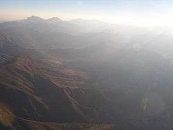
The Lesotho Highlands from the air | |
 The Lesotho Highlands in a map of Southern Africa. | |
| Country | Lesotho |
| Elevation | 2,000 m (7,000 ft) |
|
| |


The Lesotho Highlands are formed by the Drakensberg and Maloti mountain ranges in the east and central parts of the country of Lesotho. Foothills form a divide between the lowlands and the highlands.[1] Snow is common in the highlands in the winter.
Location and description
The Highlands are located to the southeast of the Highveld, encompassing the whole eastern part of Lesotho.[2] The average annual rainfall is nearly 1,000 mm (40 inches) in some parts of the high ranges. Temperature is closely related to elevation in the Lesotho Highlands. In general, the mean July (winter) temperatures stay around 7 °C (45 °F).
The Lesotho Highlands form a localized high spot on the Central Plateau of the Great Escarpment. This is because it is capped by a 1400 m thick layer of erosion resistant lava[3] which welled up and spread across most of Southern Africa when it was still part of Gondwana.[4] Most of this lava has eroded away together with a layer of Karoo sedimentary rocks several kilometres thick on top of which the lava was poured out 182 million years ago. Only a small patch of this lava remains and covers much of Lesotho. The Lesotho Highlands have been deeply eroded by the tributaries of the Orange River which drain these highlands towards the south-west by means of erosion gulleys which turn into deep valleys further downstream. This gives this high region is very rugged, mountainous appearance. There are so many of these tributaries that the whole terrain of the highlands has a very rugged mountainous appearance, both from the ground and from the air.
Flora
There are numerous species of plants in the highlands.[5][6] The soil cover in the upland areas is discontinuous and immature. Soils in the Lesotho Highlands differ according to the host rock (basalt) and the influence of freeze and thaw processes; generally they are dominated by mollisols.[7]
Some sectors of the Lesotho Highlands are part of the Drakensberg alti-montane grasslands and woodlands ecoregion.[8]
Fauna
The Lesotho Highlands are one of the endemic bird areas of the world.
The orange-breasted (or Drakensberg) rockjumper is an endemic bird species of the Lesotho Highlands and areas surrounding them in South Africa.[9]
Threats and preservation
The Lesotho Highlands Water Project (LHWP) is an ongoing water supply and hydropower project in the area of the Highlands. Developed in partnership between the governments of Lesotho and South Africa, it comprises a system of several large dams and tunnels throughout the territory of both countries. The project allegedly is said to have had so far negative social and environmental effects.[10]
See also
References
- ↑ "Lesotho travel guide". The Africa Guide. Retrieved 2008-04-19.
- ↑ Atlas of Southern Africa p. 13 (1984) Readers Digest & the Directorate of Surveys and Mapping
- ↑ Geological Map of South Africa, Lesotho and Swaziland. (1970). Council for Geoscience, Geological Survey of South Africa.
- ↑ McCarthy t. & Rubidge B. (2005) The Story of Earth & Life. p. 192, 209-269. Struik Publishers, Cape Town.
- ↑ SADC - Lesotho
- ↑ Indigenous Forest and Woodland in the Kingdom of Lesotho
- ↑ R. M. Cowling, D. M. Richardson, S. M. Pierce, Vegetation of Southern Africa. p. 16
- ↑ Drakensberg alti-montane grasslands and woodlands - WWF
- ↑ Thompson, Hazell S. (2003). "Rockjumpers and Rockfowl". In Christopher Perrins (Ed.). Firefly Encyclopedia of Birds. Firefly Books. p. 515. ISBN 1-55297-777-3.
- ↑ Hoover, Ryan (2001). Pipe Dreams - The World Bank’s Failed Efforts to Restore Lives and Livelihoods of Dam-Affected People in Lesotho (PDF) (Report). International Rivers Network. Archived from the original (PDF) on 19 August 2007.
External links
- ISS - Environmental change and human security in Lesotho: The role of the Lesotho Highlands Water Project in environmental degradation
- Late Holocene Neoglacial conditions from the Lesotho highlands, southern Africa: Phytolith and stable carbon isotope evidence from the archaeological site of Likoaeng
- Lesotho Flora
Coordinates: 29°0′0″S 28°30′0″E / 29.00000°S 28.50000°E