Leninsky City District, Perm
.svg.png)
Leninsky City District (Russian: Ле́нинский райо́н) is one of the seven city districts of the city of Perm in Perm Krai, Russia.[1] Population: 48,520 (2010 Census);[2] 57,569 (2002 Census);[3] 74,622 (1989 Census).[4] It is the least populous city district of Perm.
Name
The city district is named after Vladimir Lenin, a Russian revolutionary and politician and the founder of the Soviet state.
On October 4, 1954, in the center of Komsomolsky garden in front of Perm Academic Opera and Ballet Theater, the monument to Lenin was installed. The author of this monument was Soviet sculptor Georgy Neroda, a corresponding member of USSR Academy of Arts.[5]
Geography
The city district is situated on both banks of the Kama River. The part on the right bank is sparsely populated and mostly covered by forest. The city center is situated on the left bank of Kama.
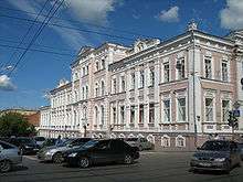
Largest streets
.jpg)
- Lenina Street (Улица Ленина)
- Komsomolsky Avenue (Комсомольский проспект)
Establishments
Educational establishments:
- Perm State Technical University (Russian: Пермский государственный технический университет);
- Perm State Institute of Arts and Culture (Russian: Пермский государственный институт искусств и культуры).
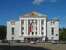
Theatres:
- Perm Academic Opera and Ballet Theater (Russian: Пермский академический театр оперы и балета);
- Perm Academic Drama Theater (Russian: Пермский академический театр драмы).
References
- ↑ Законодательное собрание Пермской области. Закон №416-67 от 28 февраля 1996 г. «Об административно-территориальном устройстве Пермского края», в ред. Закона №504-ПК от 9 июля 2015 г. «О внесении изменений в Закон Пермской области "Об административно-территориальном устройстве Пермского края"». Вступил в силу с момента опубликования. Опубликован: "Звезда", №38, 12 марта 1996 г. (Legislative Assembly of Perm Oblast. Law #416-67 of February 28, 1996 On the Administrative-Territorial Structure of Perm Krai, as amended by the Law #504-PK of July 9, 2015 On Amending the Law of Perm Oblast "On the Administrative-Territorial Structure of Perm Krai". Effective as of the moment of publication.).
- ↑ Russian Federal State Statistics Service (2011). "Всероссийская перепись населения 2010 года. Том 1" [2010 All-Russian Population Census, vol. 1]. Всероссийская перепись населения 2010 года (2010 All-Russia Population Census) (in Russian). Federal State Statistics Service. Retrieved June 29, 2012.
- ↑ Russian Federal State Statistics Service (May 21, 2004). "Численность населения России, субъектов Российской Федерации в составе федеральных округов, районов, городских поселений, сельских населённых пунктов – районных центров и сельских населённых пунктов с населением 3 тысячи и более человек" [Population of Russia, Its Federal Districts, Federal Subjects, Districts, Urban Localities, Rural Localities—Administrative Centers, and Rural Localities with Population of Over 3,000] (XLS). Всероссийская перепись населения 2002 года [All-Russia Population Census of 2002] (in Russian). Retrieved August 9, 2014.
- ↑ Demoscope Weekly (1989). "Всесоюзная перепись населения 1989 г. Численность наличного населения союзных и автономных республик, автономных областей и округов, краёв, областей, районов, городских поселений и сёл-райцентров" [All Union Population Census of 1989: Present Population of Union and Autonomous Republics, Autonomous Oblasts and Okrugs, Krais, Oblasts, Districts, Urban Settlements, and Villages Serving as District Administrative Centers]. Всесоюзная перепись населения 1989 года [All-Union Population Census of 1989] (in Russian). Институт демографии Национального исследовательского университета: Высшая школа экономики [Institute of Demography at the National Research University: Higher School of Economics]. Retrieved August 9, 2014.
- ↑ (Russian) С. А. Торопов. Пермь: путеводитель.—Пермь: Кн. изд-во, 1986.
Coordinates: 58°02′00″N 56°13′00″E / 58.0333°N 56.2167°E