Lena River
| Lena River (Лена, Зүлгэ, Өлүөнэ) | |
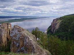 The Lena Pillars along the river near Yakutsk | |
| Country | Russia |
|---|---|
| Tributaries | |
| - left | Kirenga, Vilyuy |
| - right | Vitim, Olyokma, Aldan |
| Source | |
| - location | Baikal Mountains, Irkutsk Oblast, Russia |
| - elevation | 1,640 m (5,381 ft) |
| Mouth | Lena Delta |
| - location | Arctic Ocean, Laptev Sea |
| Length | 4,472 km (2,779 mi) |
| Basin | 2,500,000 km2 (965,255 sq mi) |
| Discharge | for Laptev Sea[1] |
| - average | 16,871 m3/s (595,794 cu ft/s) |
| - max | 241,000 m3/s (8,510,835 cu ft/s) |
| - min | 366 m3/s (12,925 cu ft/s) |
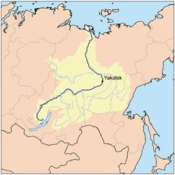 Lena River watershed
| |
The Lena (Russian: Ле́на, IPA: [ˈlʲɛnə]; Mongolian: Зүлгэ, Zülge; Buryat: Зүлхэ, Zülxe; Yakut: Өлүөнэ, Ölüöne) is the easternmost of the three great Siberian rivers that flow into the Arctic Ocean (the other two being the Ob and the Yenisei). It is the 11th longest river in the world and has the 9th largest watershed. It is also the 3rd largest river in Asia. It is the largest among the rivers whose watershed is entirely within the Russian territorial boundaries.
Course
Rising at a height of 1,640 meters (5,381 ft) at its source in the Baikal Mountains south of the Central Siberian Plateau, 7 kilometres (4 mi) west of Lake Baikal, the Lena flows northeast, being joined by the Kirenga River, Vitim River and Olyokma River. From Yakutsk it enters the lowlands and flows north until joined by its right-hand tributary the Aldan River and its most important left-hand tributary, the Vilyuy River. After that, it bends westward, flowing besides the Verkhoyansk Range and then it makes its way nearly due north to the Laptev Sea, a division of the Arctic Ocean, emptying south-west of the New Siberian Islands by the Lena Delta – 30,000 square kilometres (11,583 sq mi) in area,[2] and traversed by seven principal branches, the most important being the Bykovsky channel, farthest east.
Landmarks
.jpg)
.jpg)
In the upper section west and northwest of Lake Baikal the river flows mostly north.[3] 4400: From a small lake in the Baikal Range, in the Baikal-Lena Reserve, 10 km west of Lake Baikal, 1800 m in altitude, the Lena flows north 19 km, losing 600 m in altitude and becomes passable by rafts. It turns west and then south losing another 600 meters in 128 km, to Chanchur, where there is a ranger station. 4222: Kachug: start of navigation, road to Irkutsk. 4197:Verkholensk:mouth of the Kulenga River, northwest through mountains, Tutura River. 4108:Zhigalovo:start of passenger service, including hydrofoil to Ust-Kut.
In the central section the river flows mostly northeast. 3705: Ust-Kut: northwest of the northern tip of Lake Baikal. In Cossack times, this was the site of a portage between the Yenesei and Lena. Today it is the point where the Baikal-Amur Mainline railway crosses the Lena on a bridge and it handles 80% of cargo in the Sakha Republic region. 3397:Kirensk: port and former Cossack portage. 3101: 'The devil's path', a section treacherous in flood. 3096: Shcheki ('the cheeks'), a narrow section with cliffs and twists. Sakha Republic border. 2955:Vitim: and Vitim River from the south. We are now northeast of Lake Baikal. River widens. Many dead trees in the water. 2931:Peledui:Peledui River, ship repair company and salt mines. 2744:Lensk:the most important port between Kirensk and Yakutsk. Road 230 km north to the Mir Mine. Here was a stopping point of the 'Perlinsky Trakht', a former courier route. Lena turns southeast and then northeast. 2587:Chepaevo: 2547:Macha, 2937: Olyokminsk:, Olyokma River from the south. River widens to 2 km and has extensive flood plains. 2213:Uritskoe, 2030-1850: Lena Pillars: cliffs along the right bank. 1937:Sinsk, Sinsk River and petroglyphs. 1820:Mokhsogollokh: ferry and paved road to Yakutsk on the opposite(west) bank. River turns north. 1805:Pokrovsk: downstream:Tabaga Cliffs, narrows, power line and planned site of bridge for the Amur Yakutsk Mainline railroad. Nizhny Bestyakh: 13 km southeast of Yakutsk on the left bank, Lena Highway comes in from the south. The Kolyma Highway to the Pacific starts nearby.
In the lower section the Lena flows mostly north, through Yakutsk and meeting the Aldan River from the east. At 1373 km from the mouth, the Lena passes by the Sangar coal mines, then meets the Vilyuy River from the west, passes into the Arctic Circle, Agraphena Island and into the Lena Delta before reaching its mouth, five degrees north of the arctic circle, at Tiksi, on the mainland east to the delta.
Basin
The total length of the river is estimated at 4,400 km (2,700 mi). The area of the Lena river basin is calculated at 2,490,000 square kilometres (961,394 sq mi). Gold is washed out of the sands of the Vitim and the Olyokma, and mammoth tusks have been dug out of the delta.
Tributaries
The Kirenga River flows north between the upper Lena and Lake Baikal. The Vitim River drains the area northeast of Lake Baikal. The Olyokma River flows north. The Amga River makes a long curve southeast and parallel to the Lena and flows into the Aldan. The Aldan River makes similar curve southeast of the Aldan and flows into the Lena north of Yakutsk. The Maya River, a tributary of the Aldan, drains an area almost to the Sea of Okhotsk. The T-shaped Chona-Vilyuy River system drains most of the area to the west.
History
| Lena River from a source to Kachug | ||||||||||||||||||||||||||||||||||||||||||||||||||||||||||||||||||||||||||||||||||||||||||||||||||||||||||||||||||||||||||||||||||||||||||||||||||||||||||||||||||||||||||||||||||||||||||||||||||||||||
|---|---|---|---|---|---|---|---|---|---|---|---|---|---|---|---|---|---|---|---|---|---|---|---|---|---|---|---|---|---|---|---|---|---|---|---|---|---|---|---|---|---|---|---|---|---|---|---|---|---|---|---|---|---|---|---|---|---|---|---|---|---|---|---|---|---|---|---|---|---|---|---|---|---|---|---|---|---|---|---|---|---|---|---|---|---|---|---|---|---|---|---|---|---|---|---|---|---|---|---|---|---|---|---|---|---|---|---|---|---|---|---|---|---|---|---|---|---|---|---|---|---|---|---|---|---|---|---|---|---|---|---|---|---|---|---|---|---|---|---|---|---|---|---|---|---|---|---|---|---|---|---|---|---|---|---|---|---|---|---|---|---|---|---|---|---|---|---|---|---|---|---|---|---|---|---|---|---|---|---|---|---|---|---|---|---|---|---|---|---|---|---|---|---|---|---|---|---|---|---|---|
Legend
| ||||||||||||||||||||||||||||||||||||||||||||||||||||||||||||||||||||||||||||||||||||||||||||||||||||||||||||||||||||||||||||||||||||||||||||||||||||||||||||||||||||||||||||||||||||||||||||||||||||||||
It is commonly believed that the Lena derives its name from the original Even-Evenk name Elyu-Ene, which means "the Large River".

According to folktales related a century later, in the years 1620–1623 a party of Russian fur hunters under the leadership of Demid Pyanda sailed up Lower Tunguska, discovered the Lena, and either carried their boats there or built new ones. In 1623 Pyanda explored some 2,400 kilometres (1,500 mi) of the river from its upper reaches to the central Yakutia.[4] In 1628 Vasily Bugor and 10 men reached the Lena, collected ''yasak'' (tribute) from the natives and then founded Kirinsk in 1632. In 1631 the voyevoda of Yeniseisk sent Pyotr Beketov and 20 men to construct an ostrog at Yakutsk (founded in 1632). From Yakutsk other expeditions spread out to the south and east. The Lena delta was reached in 1633.
Baron Eduard Von Toll, accompanied by Alexander von Bunge, led an expedition that explored the Lena delta and the islands of New Siberia on behalf of the Russian Imperial Academy of Sciences in 1885. In1886 they investigated the New Siberian Islands and the Yana River and its tributaries. During one year and two days the expedition covered 25,000 kilometres (16,000 mi), of which 4,200 kilometres (2,600 mi) were up rivers, carrying out geodesic surveys en route.
Vladimir Ilyich Ulyanov may have taken his alias, Lenin, from the river Lena, when he was exiled to the Central Siberian Plateau, but this is uncertain.
Delta

At the end of the Lena River there is a large delta that extends 100 kilometres (62 mi) into the Laptev Sea and is about 400 km (250 mi) wide. The delta is frozen tundra for about seven months of the year, but in May the region is transformed into a lush wetland for the next few months. Part of the area is protected as the Lena Delta Wildlife Reserve.
The Lena delta divides into a multitude of flat islands. The most important are (from west to east): Chychas Aryta, Petrushka, Sagastyr, Samakh Ary Diyete, Turkan Bel'keydere, Sasyllakh Ary, Kolkhoztakh Bel'keydere, Grigoriy Diyelyakh Bel'kee (Grigoriy Islands), Nerpa Uolun Aryta, Misha Bel'keydere, Atakhtay Bel'kedere, Arangastakh, Urdiuk Pastakh Bel'key, Agys Past' Aryta, Dallalakh Island, Otto Ary, Ullakhan Ary and Orto Ues Aryta.
Turukannakh-Kumaga is a long and narrow island off the Lena delta's western shore.
One of the Lena delta islands, Ostrov Amerika-Kuba-Aryta or Ostrov Kuba-Aryta, was named after the island of Cuba during Soviet times. It is on the northern edge of the delta.[5]
Further reading
- Alexander von Bunge & Baron Eduard Von Toll (1887), The Expedition to the New Siberian Islands and the Yana country, equipped by the Imperial Academy of Sciences.
See also
- Lena Pillars
- List of rivers of Russia
- List of longest undammed rivers
- William Barr, writer of The First Soviet Convoy to the Mouth of the Lena.
References
- ↑ http://www.abratsev.narod.ru/biblio/sokolov/p1ch23b.html, Sokolov, Eastern Siberia // Hydrography of USSR. (in russian)
- ↑ "Lena River Delta - A Global Ecoregion". World Wide Fund for Nature. 2006-07-06. Retrieved 2008-05-23.
- ↑ numbers are kilometers from the mouth of the Lena. Source:Athol Yates and Nicholas Zvegentzon, 'Siberian BAM Guide', 1995, second edition 2001.
- ↑ http://www.randewy.ru/karta/geogr24.html
- ↑ "Ostrov Amerika-Kuba-Aryta"
-
 This article incorporates text from a publication now in the public domain: Chisholm, Hugh, ed. (1911). "Lena". Encyclopædia Britannica. 16 (11th ed.). Cambridge University Press.
External links
| Wikimedia Commons has media related to Lena River. |
- NASA Earth Observatory page on flooding on the Lena River
- Information and a map of the Lena's watershed
- Permafrost in the Lena Delta
- Alfred Wegner institute (AWI) Publications, Berichte zur Polar- und Meeresforschung (Reports on polar and marine research) - free, downloadable research reports on the biology, geology, oceanography, hydrology, paleontology, paleoclimatology, fauna, flora, soils, cryology, and so forth of the Lena Delta, Laptev Sea, and other parts of the Arctic Circle.
Shipbuilding and shipping on the Lena River | |||||||||||
|---|---|---|---|---|---|---|---|---|---|---|---|
| Shipbuilding |
| ||||||||||
| River ports |
| ||||||||||
| Ship types | |||||||||||
| Well-known vessels |
| ||||||||||
| Well-known travels |
| ||||||||||
| River accidents | |||||||||||
| Significant persons |
| ||||||||||
Coordinates: 73°N 127°E / 73°N 127°E