Leira, Ørsta
| Leira | |
|---|---|
| Village | |
|
View of Leira | |
 Leira  Leira Location in Møre og Romsdal | |
| Coordinates: 62°07′17″N 06°35′05″E / 62.12139°N 6.58472°ECoordinates: 62°07′17″N 06°35′05″E / 62.12139°N 6.58472°E | |
| Country | Norway |
| Region | Western Norway |
| County | Møre og Romsdal |
| District | Sunnmøre |
| Municipality | Ørsta Municipality |
| Elevation[1] | 55 m (180 ft) |
| Time zone | CET (UTC+01:00) |
| • Summer (DST) | CEST (UTC+02:00) |
| Post Code | 6190 Bjørke |
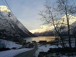
Leira is a small village in the Hjørundfjord area of the municipality of Ørsta in Møre og Romsdal county, Norway. It lies between the villages of Bjørke and Viddal, at the end of Hjørundfjorden. The village is located in the Sunnmørsalpene mountains, about 6 kilometres (3.7 mi) from the mountains Skårasalen (to the northwest), Jakta (to the northeast), Kvitegga (to the southeast), and Hornindalsrokken (to the south).
There are about 15–20 residents in Leira, with most residents farming their land. Leira is fairly isolated, with only one road leading to it. The road goes from Bjørke, through a 2-kilometre (1.2 mi) long tunnel through the mountain, Kamben, before reaching Leira. The road continues along the fjord to Viddal where the road ends. The closest urban area is the village of Volda, about 38 kilometres (24 mi) to the west of Leira.
The name
The name is derived from leire 'clay'.