Leicester Urban Area
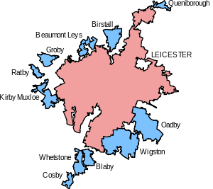
Map of the Leicester Urban Area {2001}.
The Leicester Urban Area or Leicester Built Up Area is an urban agglomeration centered on the City of Leicester in the English Midlands. With a population of 508916 at the time of the 2011 census, the Built Up Area is the eleventh largest in England and thirteenth largest in Great Britain. It comprises Leicester itself and several outlying suburbs, towns and villages which are all situated in close proximity to the city.
| Urban Subdivision | Population (2001 census)[1] | Population (2011 census)[2] |
|---|---|---|
| Leicester | 330574 | 443,760 |
| Wigston | 33,116 | |
| Oadby | 22,679 | |
| Birstall | 11,480 | 12,216 |
| Kirby Muxloe | 9,500 | |
| Groby | 6,256 | 6,782 |
| Blaby | 6,163 | |
| Whetstone | 6,100 | 12,760 |
| Beaumont Leys | 5,579 | |
| Ratby | 3,862 | |
| Cosby | 3,647 | 3,506 |
| Queniborough | 2,257 | 2,326 |
| Syston | 12,804 | |
| Littlethorpe | 1,766 | |
| Narborough/Enderby | 12,996 | |
| Total Urban Area | 441,213 | 508,916 |
Notes:
- The ONS's definition of "Leicester" in the 2001 census excluded the suburb of Beaumont Leys, which was counted separately, and amalgamated several surrounding towns and villages. Its boundaries and population were not the same as that of the Leicester UA, which had a separate population of 279,921 at the 2001 Census.
Coordinates: 52°38′N 1°08′W / 52.63°N 1.13°W
See also
References
- Office for National Statistics: Census 2001 - Table KS01 (Usual resident population)
- Office for National Statistics: Census 2001 - Maps and index to urban areas
- ↑ "United Kingdom: Urban Areas". ONS. Retrieved 11 November 2016.
- ↑ "United Kingdom: Urban Areas". ONS. Retrieved 11 November 2016.
England Portal | |
| Unitary authorities | |
| Boroughs or districts | |
| Major settlements | |
| Topics | |
This article is issued from Wikipedia - version of the 11/25/2016. The text is available under the Creative Commons Attribution/Share Alike but additional terms may apply for the media files.