Leeward Point Field
| Leeward Point Field Leeward Airfield Naval Station Guantanamo Bay | |||||||||||
|---|---|---|---|---|---|---|---|---|---|---|---|
|
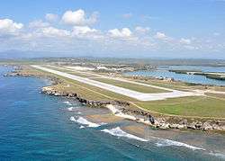
Aerial view, 6 May 2010 | |||||||||||
| IATA: NBW – ICAO: MUGM | |||||||||||
| Summary | |||||||||||
| Airport type | Military | ||||||||||
| Operator | United States Navy | ||||||||||
| Location | Guantánamo Bay, Cuba | ||||||||||
| Elevation AMSL | 56 ft / 17 m | ||||||||||
| Coordinates | 19°54′23″N 075°12′25″W / 19.90639°N 75.20694°WCoordinates: 19°54′23″N 075°12′25″W / 19.90639°N 75.20694°W | ||||||||||
| Map | |||||||||||
 MUGM Location in Cuba | |||||||||||
| Runways | |||||||||||
| |||||||||||
Leeward Point Field[1] (IATA: NBW, ICAO: MUGM), also known as Leeward Airfield,[3] is a U.S. military airfield located at Naval Station Guantanamo Bay in Guantánamo Bay, Cuba.
Facilities
The airport resides at an elevation of 56 ft (17 m) above mean sea level. It has one runway designated 10/28 with an asphalt surface measuring 8,000 ft × 200 ft (2,438 m × 61 m).[1]
References
- 1 2 3 Airport information for MUGM at World Aero Data. Data current as of October 2006.Source: DAFIF.
- ↑ Airport information for NBW at Great Circle Mapper. Source: DAFIF (effective October 2006).
- ↑ "Photos of Leeward Airfield". Joint Task Force Guantanamo. Retrieved 30 May 2010.
External links
![]() Media related to Aviation at Naval Base Guantanamo Bay at Wikimedia Commons
Media related to Aviation at Naval Base Guantanamo Bay at Wikimedia Commons
This article is issued from Wikipedia - version of the 12/4/2016. The text is available under the Creative Commons Attribution/Share Alike but additional terms may apply for the media files.