Leeds Outer Ring Road
| |
|---|---|
| Major junctions | |
| From: | Beeston |
| To: | Bramley |
| Road network | |

| |
|---|---|
|
Ring Road Moortown A6120 | |
| Major junctions | |
| From: | Colton |
| To: | Farsley |
| Road network | |
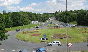
The Leeds Outer Ring Road is a main road that runs around most of the perimeter of the city of Leeds, West Yorkshire, England. The ring road is approximately 25 miles (40 km) long and consists of single and dual carriageways. Hence the road is not a loop and so is not a true ring road, although it is designated as such.
The road begins in Belle Isle and ends in Colton at junction 46 of the M1 motorway. It begins in Belle Isle as an un-numbered road and goes through to Beeston. It is then designated the A6110 between Beeston and Bramley a dual carriageway, before running concurrently with the Stanningley By-Pass A647 also a dual carriageway but with grade separated junctions.
For the rest of the way between Farsley and Colton the road is the A6120 and it is a mixture of single and dual carriageway as far as Austhorpe. The ring road becomes the A63 road following a short concurrency and ends in Colton.
There are future proposals for the complete dualling of the congested Outer Ring Road but they are not priority in the Leeds Transport Plan.
Ring Road names
The road name of the ring road reflects the district it passes through. The table below states the name of the ring road and the number of carriageways in each district.
| Road Number | Road Name | Dual or Single Carriageway | Intersection with |
|---|---|---|---|
| Unclassified | Ring Road Middleton | Single | |
| Unclassified | Middleton Park Road | Single (short section dual | |
| Unclassified | Ring Road Beeston Park | Single | A653 |
| A6110 | Ring Road Beeston | Dual/Single | A643, M621 Junction 1, A62 |
| A6110 | Ring Road Lower Wortley | Dual | A58 |
| A6110 | Ring Road Farnley | Dual | |
| A6110 | Ring Road Bramley | Dual | B6154 |
| A647 | Stanningley By Pass | Dual | A6110 |
| A6120 | Ring Road Farsley | Single | A647, B6157, B6156 |
| A6120 | Horsforth New Road | Single | A657 |
| A6120 | Broadway | Single | A65 |
| A6120 | Ring Road Horsforth | Single | |
| A6120 | Ring Road West Park | Dual | A660 |
| A6120 | Ring Road Weetwood | Dual | |
| A6120 | Ring Road Adel | Dual | |
| A6120 | Ring Road Meanwood | Dual | |
| A6120 | Ring Road Moortown | Dual | A61 |
| A6120 | Ring Road Shadwell | Single | A58 |
| A6120 | Ring Road Seacroft | Single/Dual | A58, A64 |
| A6120 | Ring Road Cross Gates | Dual | |
| A6120 | Station Road | Dual | |
| A6120 | Ring Road Halton | Single | |
| A6120 | Selby Road | Dual | A63, M1 motorway (Junction 46). |
As A6110
- A643 road Ring Road Beeston / Elland Road There is a brief concurrency where the A6110 and A643 run together as 40mph dual carriageway for about 1/2 mile.
As A6120
- A64 road Ring Road Seacroft There is a brief concurrency where the A6120 and A64 run together as 70mph dual carriageway for about 1/2 mile.
- A63 road Selby Road The former A63 between M1 J46 and Whitkirk Roundabout was redesignated A6120 in 2001.
External links
Coordinates: 53°50′34″N 1°34′13″W / 53.8429°N 1.5702°W