Lechtal

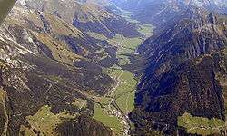
The Lechtal is an alpine valley in Austria, the greater part of which belongs to the state of Tyrol and the smaller part to Vorarlberg. The Lech river flows through the valley.
Location
The valley is bounded geographically by the Lechtal Alps in the south and Allgäu Alps in the north. The upper Lech valley, with its settlements of Zürs am Arlberg and Lech in Vorarlberg, is a well-known ski region, whilst the rest of the valley is rather less well developed for tourism. There are industrial and trading estates, especially in the Reutte Basin.
Several side valleys branch off the Lechtal including, on the left-hand side, the Hornbachtal and the Tannheimer Tal. On the right, a road through the Namlostal links Stanzach with Berwang and Bichlbach. The route through the Bschlabertal goes to Bschlabs, Boden and over the Hahntennjoch pass to Imst. The Gramaistal and the Kaisertal are also right-hand, side valleys of the Lechtal. Near Füssen the valley transitions to the Bavarian Alpine Foreland.
The settlements of the Tyrol Lech valley are: Steeg - Hägerau - Holzgau - Stockach - Bach - Elbigenalp - Häselgehr - Elmen - Martinau - Vorderhornbach - Stanzach - Forchach, the villages in the side valleys are: Namlos - Hinterhornbach - Bschlabs - Boden - Gramais - Kaisers.
Dialects
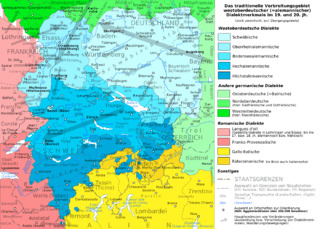
The Austrian part of the Lech valley is remarkable in that it is home to three very different dialect regions. The municipalities in the upper reaches of the valley, up to and including Steeg and Kaisers, belong to the Highest Alemannic German dialect region. The central Lechtal valley from Holzgau to Stanzach is part of the Bavarian language region. The lowest part of the valley from Forchach, in the east as far as the Lähn (municipality of Bichlbach) is predominantly a Swabian speaking area. The Highest Alemannic and Swabian areas are part of the Alemannic German dialect region.
Tyrolean Lechtal National Park
In 1997 serious work began on a proposal to establish the Lech water meadows and its side valleys as a national park within the Tyrolean Lech valley. The Nationalpark Tiroler Lechtal was to cover an area of 4,138 hectares. By 2000 the region was notified to the European Commission in Brussels as a Natura 2000 site.
The official evaluation process for the national park began in early February 2003, but, in 2004, the Tyrolean state government decided instead to establish a nature reserve and grant it the status of a nature park. The decision in favour of a nature park and against an internationally recognised national park was partly because of the interference with hunting that a national park would have caused.
Flora and fauna
Worth mentioning are the inner Alpine river landscapes with their juniper trees, stands of Myricaria (Myricaria germanica), the variety of birds and at least 1,160 identified wildflowers.
External links
- www.tiroler-lech.at
- www.lechtal.at
- Map of the valley at Google Maps
- private portal about the Tyrol Lech valley
Coordinates: 47°19′50″N 10°31′40″E / 47.33056°N 10.52778°E