Leathley
| Leathley | |
 The Parish Church of St Oswald, Leathley, built circa 1100, enlarged in the 1470s and renovated in 1869 |
|
 Leathley |
|
| Population | 181 (2011 Census) |
|---|---|
| OS grid reference | SE232471 |
| Civil parish | Leathley |
| District | Harrogate |
| Shire county | North Yorkshire |
| Region | Yorkshire and the Humber |
| Country | England |
| Sovereign state | United Kingdom |
| Police | North Yorkshire |
| Fire | North Yorkshire |
| Ambulance | Yorkshire |
| EU Parliament | Yorkshire and the Humber |
Coordinates: 53°55′12″N 1°38′49″W / 53.920°N 1.647°W
Leathley is a village and civil parish in the Harrogate district of North Yorkshire, England, the parish includes the townships of both Castley and Leathley.[1] It is near the border with West Yorkshire and the River Wharfe, 1 mile north-east of Otley. The B6161 runs through the village, connecting Leathley with Killinghall in the North and Pool-in-Wharfedale in the south.

According to the 2011 census Leathley had a population of 181[2]
In 1870–72, John Marius Wilson's Imperial Gazetteer of England and Wales described Leathley like this: a village, a township, and a parish in Otley district, W. R. Yorkshire. The village stands on an affluent of the river Wharfe, 3 miles NW of Arthing. ton r. station, and 3 NE of Otley; and is. a picturesque place.[3]
Later in the 1880s Leathley was described by John Bartholomew as:
- 3 miles NE. of Otley – par., 2089 ac., pop. 237; township, 1565 ac., pop. 150; contains the seat of Leathley Hall[4]
The name Leathley originates from the old English meaning 'slope wood/clearing' referring to the rural nature of the landscape.[5]
History
From information transcribed from the early 1820s the Church and school in the parish of Leathley was described: " The Church is a rectory in the deanry of the Ainsty. Here is a School House and four Alms Houses, founded in 1769, for the master, to teach the children of the township of Leathley, reading, writing, English grammar."[6]
In John Marius Wilson's Imperial Gazetteer of England and Wales written between 1870 and 1872, he describes the property ownership in Leathley the Parish church and other key features of a developing community:
"The manor and much of the land belong to F. H. Fawkes, Esq. Leathley Hall is the seat of the Rev. A. Fawkes."[7]
"The church is very ancient, of various dates; comprises nave, three aisles, and transept, with a Norman tower; and contains several mural monuments. There are a Methodist chapel, an endowed school, a national school, and an hospital."[8]
Population
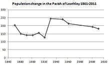
The Parish register of 1821 concluded that the township of Leathley had a population of 312 persons.[9] Between the period from the 1821 parish register to the 1921 census the total population of the civil parish of Leathley decreased gradually to 127 persons.[10] However the total population rose between 1921 and 1951 to 241 persons, reaching a high of 245 persons in the 1931 census statistics, as a result of an increase in agricultural industry during this period.[11] Between the period of 1961 to 2011 census data shows that the population of Leathley civil parish has declined gradually from 214 persons to 181.[12] As shown in the Parish of Leathley total population time series graph.
Occupation and employment
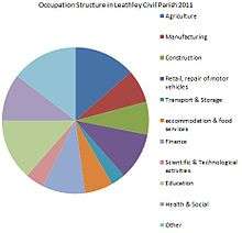
Before the industrial revolution Leathley Civil Parish was very much focused on agricultural industry with agriculture accounting for over 73 percent of employment of males aged over 20 in 1831.[13] In 1881 occupation figures again show that agriculture was the parish's main occupation with around 34 percent of all industry relating to agriculture.[14]

However, as the 2011 census data shows Leathley has changed its industry dependency, according to the 2011 census data under 14 percent of workers in Leathley Civil Parish are in the agricultural sector, with industries such as finance and education becoming large employers in the Parish.[15]
References
- ↑ Hinson, Colin. "The Ancient Parish of Leathley".
- ↑ "Leathley (Parish): Key figures for 2011 Census: Key Statistics". Neighbourhood Statistics. Office for National Statistics. Retrieved 12 May 2013.
- ↑ Wilson, John Marius. "Imperial Gazetteer of England and Wales".
- ↑ Bartholomew, John (1887). "Gazetteer of the British Isles". Bartholomew. Retrieved 4 February 2013.
- ↑ Mills, A.D. "Dictionary of English place names".
- ↑ Hinson, Colin. "The Ancient Parish of Leathley".
- ↑ Wilson, John Marius (1870–72). "Imperial Gazetteer of England and Wales (1870–72)". Retrieved 26 March 2013.
- ↑ Wilson, John Marius (1870–72). "Imperial Gazetteer of England and Wales (1870–72)". Retrieved 26 March 2013.
- ↑ "Observations, enumeration and parish register abstracts, 1821".
- ↑ "Leathley CP/AP through time | Population Statistics | Total Population". A Vision of Britain through Time. University of Portsmouth. Retrieved 1 May 2013.
- ↑ "Leathley CP/AP through time | Population Statistics | Total Population". A Vision of Britain through Time. University of Portsmouth. Retrieved 1 May 2013.
- ↑ "Leathley CP/AP through time | Population Statistics | Total Population". A Vision of Britain through Time. University of Portsmouth. Retrieved 1 May 2013.
- ↑ "Leathley CP/AP through time | Industry Statistics | Males aged 20 & over, in 9 occupational categories". A Vision of Britain through Time. University of Portsmouth. Retrieved 1 May 2013.
- ↑ "Leathley CP/AP through time | Industry Statistics | Occupation data classified into the 24 1881". , A Vision of Britain through Time. University of Portsmouth. Retrieved 1 May 2013.
- ↑ "Leathley Civil Parish Industry 2011". Neighbourhood Statistics. Office for National Statistics. Retrieved 1 May 2013.
External links
![]() Media related to Leathley at Wikimedia Commons
Media related to Leathley at Wikimedia Commons