Le Verger
| Le Verger Gwerzher | |
|---|---|
|
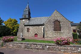
The church in Le Verger | |
 Le Verger | |
|
Location within Brittany region  Le Verger | |
| Coordinates: 48°04′13″N 1°55′55″W / 48.0703°N 1.9319°WCoordinates: 48°04′13″N 1°55′55″W / 48.0703°N 1.9319°W | |
| Country | France |
| Region | Brittany |
| Department | Ille-et-Vilaine |
| Arrondissement | Rennes |
| Canton | Montfort-sur-Meu |
| Intercommunality | Rennes Métropole |
| Government | |
| • Mayor (2014–2020) | Charles Marchal |
| Area1 | 6.87 km2 (2.65 sq mi) |
| Population (2009)2 | 1,539 |
| • Density | 220/km2 (580/sq mi) |
| Time zone | CET (UTC+1) |
| • Summer (DST) | CEST (UTC+2) |
| INSEE/Postal code | 35351 / 35160 |
| Elevation | 29–92 m (95–302 ft) |
|
1 French Land Register data, which excludes lakes, ponds, glaciers > 1 km² (0.386 sq mi or 247 acres) and river estuaries. 2 Population without double counting: residents of multiple communes (e.g., students and military personnel) only counted once. | |
Le Verger (Breton: Gwerzher) is a commune in the Ille-et-Vilaine department of Brittany in northwestern France.
Population
Inhabitants of Le Verger are called Vergéens in French.
| Historical population | ||
|---|---|---|
| Year | Pop. | ±% |
| 1962 | 385 | — |
| 1968 | 395 | +2.6% |
| 1975 | 653 | +65.3% |
| 1982 | 722 | +10.6% |
| 1990 | 915 | +26.7% |
| 1999 | 1,099 | +20.1% |
| 2009 | 1,539 | +40.0% |
International relations
There is a partnership arrangement with the German community of Hahn am See.
See also
References
External links
| Wikimedia Commons has media related to Le Verger. |
- Official website Le Verger (French)
- French Ministry of Culture list for Le Verger (French)
This article is issued from Wikipedia - version of the 11/6/2016. The text is available under the Creative Commons Attribution/Share Alike but additional terms may apply for the media files.