Le Tholonet
| Le Tholonet | ||
|---|---|---|
|
Société du Canal de Provence | ||
| ||
 Le Tholonet | ||
|
Location within Provence-A.-C.d'A. region  Le Tholonet | ||
| Coordinates: 43°31′22″N 5°30′42″E / 43.5228°N 5.5117°ECoordinates: 43°31′22″N 5°30′42″E / 43.5228°N 5.5117°E | ||
| Country | France | |
| Region | Provence-Alpes-Côte d'Azur | |
| Department | Bouches-du-Rhône | |
| Arrondissement | Aix-en-Provence | |
| Canton | Aix-en-Provence-Nord-Est | |
| Intercommunality | Pays d'Aix | |
| Government | ||
| • Mayor (2008–2014) | Michel Legier | |
| Area1 | 10.82 km2 (4.18 sq mi) | |
| Population (2008)2 | 2,227 | |
| • Density | 210/km2 (530/sq mi) | |
| Time zone | CET (UTC+1) | |
| • Summer (DST) | CEST (UTC+2) | |
| INSEE/Postal code | 13109 / 13100 | |
| Elevation |
150–350 m (490–1,150 ft) (avg. 193 m or 633 ft) | |
|
1 French Land Register data, which excludes lakes, ponds, glaciers > 1 km² (0.386 sq mi or 247 acres) and river estuaries. 2 Population without double counting: residents of multiple communes (e.g., students and military personnel) only counted once. | ||
.svg.png)
Le Tholonet (Lou Toulounet and Lo Tolonet in Provençal) is a commune in the Bouches-du-Rhône department in southern France. Its inhabitants are called Tholonétiens.
Geography
The commune is near Aix-en-Provence, and at the foot of the montagne Sainte-Victoire. The river Arc goes through the commune.
The hamlet of Palette, which gives its name to the Palette AOC appellation, is located on the commune's territory.[1]
History
The earliest signs of human presence can be dated back to the Iron Age, and are located in the Infernet and Espinades ranges.[2]
In the nineteenth century, a small oppidum named "Ragabom camp" or "Ratabom camp" was discovered at the Infernet site.[2] The camp consists of fortifications build with large stone blocks. The ruins are barely discernible today. Archeological surveys done from 1979-1980 helped discover furnishings dated from the Iron Ages up to the 2nd century BC, a time when the site was highly populated.[2]
Population
| Historical population | ||
|---|---|---|
| Year | Pop. | ±% |
| 1793 | 470 | — |
| 1800 | 350 | −25.5% |
| 1806 | 489 | +39.7% |
| 1821 | 465 | −4.9% |
| 1831 | 501 | +7.7% |
| 1836 | 514 | +2.6% |
| 1841 | 540 | +5.1% |
| 1846 | 504 | −6.7% |
| 1851 | 602 | +19.4% |
| 1856 | 546 | −9.3% |
| 1861 | 540 | −1.1% |
| 1866 | 508 | −5.9% |
| 1872 | 501 | −1.4% |
| 1876 | 510 | +1.8% |
| 1881 | 506 | −0.8% |
| 1886 | 497 | −1.8% |
| 1891 | 505 | +1.6% |
| 1896 | 513 | +1.6% |
| 1901 | 466 | −9.2% |
| 1906 | 429 | −7.9% |
| 1911 | 383 | −10.7% |
| 1921 | 400 | +4.4% |
| 1926 | 402 | +0.5% |
| 1931 | 415 | +3.2% |
| 1936 | 421 | +1.4% |
| 1946 | 484 | +15.0% |
| 1954 | 592 | +22.3% |
| 1962 | 720 | +21.6% |
| 1968 | 953 | +32.4% |
| 1975 | 1,137 | +19.3% |
| 1982 | 1,186 | +4.3% |
| 1990 | 2,004 | +69.0% |
| 1999 | 2,259 | +12.7% |
| 2008 | 2,227 | −1.4% |
Sights
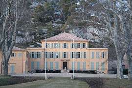
- The Château du Tholonet (in its current form) was built by Alexandre de Galliffet in the 1640s. Galliffet had bought the plot from the Jarente family, and was president of the Aix-en-Provence parliament. His grandson Louis-François added a theater for his mistress Émilie de Marignane, wife of the famous orator Mirabeau. A marble cutting mill was used for Tholonet marble, known under the name Brêche d'Alep. Currently, the domain is owned by the Société du Canal de Provence (SCP).
- Ruins of the Roman aqueduct that brought water from Saint-Antonin to Aix-en-Provence. This fifteen-kilometre aqueduct bridge, located in the Cause ravine, had a rate of nearly 80 liters per second and was one of four aqueducts that supplied Aquae Sextiae, Aix-en-Provence during the Roman period. The Aix painter Jean-Antoine Constantin drew sketches of it, which are now in the Aix-en-Provence Méjanes libraries.[2]
- An old windmill that has been restored. Currently it is used to host painting and sculpture exhibitions.
Media
- Paul Cézanne, who painted Sainte-Victoire and the black castle at Tholonet, would often eat at the Berne restaurant, today named Relais Cézanne.
- Jacqueline de Romilly, member of the Académie française, wrote the book Sur les chemins de Sainte-Victoire, published by Fallois (2001).
- In 2006, Michel Bernascolle's book Les Rapegons de Sainte-Victoire was published by Cheminements.
Personalities
- Georges Duby, a medieval historian and former member of the Académie française, is buried in Tholonet's small cemetery.
See also
References
- ↑ Quid entry for Le Tholonet
- 1 2 3 4 "Carte archéologique de la Gaule : Aix-en-Provence, pays d'Aix, val de Durance", 13/4, Fl. Mocci, N. Nin (dir.), Paris, 2006, Académie des inscriptions et belles-lettres, ministère de l'Éducation nationale, ministère de la Recherche, ministère de la Culture et de la Communication, maison des Sciences de l'homme, centre Camille-Jullian, ville d'Aix-en-Provence, communauté du pays d'Aix, p. 684-90.
External links
| Wikimedia Commons has media related to Le Tholonet. |