Le Moulin
| Le Moulin | |
|---|---|
| Highest point | |
| Elevation | 114 m (374 ft) |
| Coordinates | 49°26′09″N 2°21′39″W / 49.43583°N 2.36083°WCoordinates: 49°26′09″N 2°21′39″W / 49.43583°N 2.36083°W |
| Naming | |
| Translation | the mill (French) |
| Geography | |
| Location | Sark, Guernsey |
.svg.png)
Le Moulin is the highest point in Sark and is also the highest point of the Bailiwick of Guernsey, a British Crown Dependency in the English Channel off the coast of Normandy, with an altitude of 114 metres (374 ft).
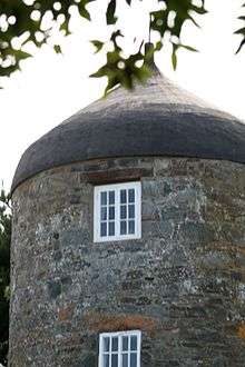
The former windmill on Sark's highest point
See also
- Geography of Guernsey
- Le Moulin de Mougins (in France)
External links
- (English) Guernsey, Answers.com.
This article is issued from Wikipedia - version of the 12/6/2015. The text is available under the Creative Commons Attribution/Share Alike but additional terms may apply for the media files.