Le Bourget
| Le Bourget | ||
|---|---|---|
|
The town hall of Le Bourget | ||
| ||
 Paris and inner ring départements | ||
| Coordinates: 48°56′07″N 2°25′32″E / 48.9353°N 2.4256°ECoordinates: 48°56′07″N 2°25′32″E / 48.9353°N 2.4256°E | ||
| Country | France | |
| Region | Île-de-France | |
| Department | Seine-Saint-Denis | |
| Arrondissement | Bobigny | |
| Canton | Le Bourget | |
| Intercommunality | Aéroport du Bourget | |
| Government | ||
| • Mayor | Vincent Capo-Canellas (NC) | |
| Area1 | 2.08 km2 (0.80 sq mi) | |
| Population (2006)2 | 13,019 | |
| • Density | 6,300/km2 (16,000/sq mi) | |
| Time zone | CET (UTC+1) | |
| • Summer (DST) | CEST (UTC+2) | |
| INSEE/Postal code | 93013 / 93350 | |
| Elevation | 38–48 m (125–157 ft) | |
| Website | www.le-bourget.fr | |
|
1 French Land Register data, which excludes lakes, ponds, glaciers > 1 km² (0.386 sq mi or 247 acres) and river estuaries. 2 Population without double counting: residents of multiple communes (e.g., students and military personnel) only counted once. | ||


Le Bourget (pronounced: [lə buʁˈʒɛ]) is a commune in the northeastern suburbs of Paris, France. It is located 10.6 km (6.6 mi) from the center of Paris.
The commune features Le Bourget Airport, which in turn hosts the Musée de l'Air et de l'Espace (Air and Space Museum).[1] A very small part of Le Bourget Airport lies on the territory of the commune of Le Bourget, which nonetheless gave its name to the airport. Most of the airport lies on the territory of the communes of Dugny, Bonneuil-en-France, and Gonesse. The Bureau d'Enquêtes et d'Analyses pour la Sécurité de l'Aviation civile is also headquartered on the airport grounds and in Le Bourget proper.[2]
International relations
Le Bourget has been twinned with Amityville, New York since 1979[3] and Zhukovsky in Russia.
Transport
Rail
Le Bourget is served by Le Bourget station on Paris RER line B. There is also an extensive freight rail yard with international traffic to Belgium, among others. Progressively, Le Bourget is planned to one of the principal transportation hub in the Paris North suburb : The Tangentielle Nord is an express tramway planned to enter in service in 2014,[4] and two train stations are planned in the long term as part of the Grand Paris Express project with the future lines 16 and 17.
Highways
The town is served by two major Highways (Autoroutes), A1 autoroute in the north of the town, and A86 autoroute in the south of the city. Those two highways ensure a direct connection to major Paris Region hubs like La Defense (A86 West), Bobigny (A86 East), Roissy Charles de Gaulle Airport (A1 North), Paris (A1 South).
Air
Paris–Le Bourget Airport is the first business flights airport in Europe. It connects with 800 destinations in Europe [5]
Culture
The world-renowned Gagosian Gallery is located in Le Bourget airport area.
Government and infrastructure
Le Bourget houses the Crèche intercommunale Maryse Bastié, an intercommunal daycare.[6]
Education
École maternelle Saint-Exupéry is the sole maternelle public nursery school in Le Bourget, while École primaire Louis Blériot is the sole élémentaire- only public school in Le Bourget. Two municipal schools, Groupe scolaire Jean Jaurès and Groupe scolaire Jean Mermoz, serve both the maternelle and élémentaire levels. Collège Didier Daurat is the sole municipal collège (junior high school). There is one public high school, Lycée Germaine Tillion (Lycée du Bourget). Institution Privée Sainte-Marie, serving the maternelle, élémentaire and collège levels, is the sole private school in Le Bourget.[7]
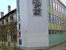
The 350-square-metre (3,800 sq ft) Le Bourget Public Library has 45,000 books and almost 100 magazines. It is located within the Urban Community of Le Bourget Airport (Communauté d’Agglomération de l’Aéroport du Bourget).[8]
Gallery

 Le Bourget Library
 Building 153, the head office of the Bureau d'Enquêtes et d'Analyses pour la Sécurité de l'Aviation Civile (BEA) at Le Bourget Airport
See also
References
- Citations
- ↑ "Address and Directions." Musée de l'Air. Retrieved on 9 September 2010.
- ↑ "How to find us." Bureau d'Enquêtes et d'Analyses pour la Sécurité de l'Aviation civile. Retrieved on 2 June 2009.
- ↑ http://www.amityvillehistoricalsociety.org/Hist.Chronological.htm
- ↑ http://www.tangentiellenord.fr/
- ↑ http://www.plainedefrance.fr/le-centre-de-ressources/actualites/mipim-2014 Pole Metropolitain du Bourget MIPIM 2014 Presentation
- ↑ "La Crèche Intercommunale." Le Bourget. Retrieved on 31 January 2012.
- ↑ "Les Etablissements Scolaires." Le Bourget. Retrieved on 6 September 2016.
- ↑ "La Bibliothèque." Le Bourget. Retrieved on 31 January 2012.
- Bibliography
External links
| Wikimedia Commons has media related to Le Bourget. |
- Commune of Le Bourget (French)