Lawrence Hill, Bristol
| Lawrence Hill | |
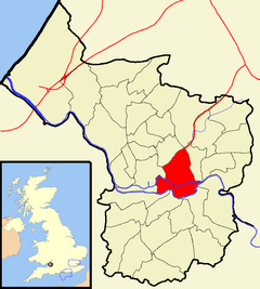 Boundaries of the city council ward |
|
| Population | 18,942 (2011.Ward)[1] |
|---|---|
| OS grid reference | ST604732 |
| Unitary authority | Bristol |
| Ceremonial county | Bristol |
| Region | South West |
| Country | England |
| Sovereign state | United Kingdom |
| Post town | BRISTOL |
| Postcode district | BS5 |
| Dialling code | 0117 |
| Police | Avon and Somerset |
| Fire | Avon |
| Ambulance | South Western |
| EU Parliament | South West England |
| UK Parliament | Bristol West |
Coordinates: 51°27′25″N 2°34′12″W / 51.457°N 2.57°W
Lawrence Hill is an electoral ward of Bristol, United Kingdom. It takes its name from a small area just to the east of the city centre, and includes the districts of Barton Hill, St Philips Marsh and Redcliffe, Temple Meads and parts of Easton and the Broadmead shopping area.[2]
It is the most deprived electoral ward in the south west region of England,[3][4] is part of the Bristol European Union Objective 2 area,[5] and has a New Deal for Communities project within its boundaries.[6] The Bristol and Bath Railway Path starts in the south of the ward.[7]
History
Lawrence Hill takes its name from a leper hospital dedicated to St Lawrence, which was founded by King John in 1208 when he was Earl of Mortain.[8] The hospital was located somewhere in the vicinity of Lawrence Hill roundabout. The right to appoint the master was held by the Crown until it was granted to Humphrey, Duke of Gloucester during the reign of Henry V (1413–22). The Hospital of St Lawrence was never rich, and by the mid 15th century it had fallen into decay. In 1465 the hospital was granted to the Dean and Chapter of Westbury College, and it remained in their possession until it was surrendered to the Crown in 1544.[8] In 1544 the properties of Westbury College, which included the Hospital of St Lawrence, were confiscated by the Crown, then sold to Sir Ralph Sadlier, who re-built the hospital as a mansion house. The estate remained in the hands of the Sadlier family until at least 1608 .[9] Queen Elizabeth I stayed at St Lawrence during her visit to Bristol in 1574,[10] which suggests that the mansion was probably a substantial building, but by the 18th century it was in ruins.[11] Today the exact location of the hospital remains unknown.
During the post-medieval period Bristol gradually expanded beyond its medieval walls and by the early 18th century there was a significant amount of development along the main east-west road through Lawrence Hill. During the 18th and early 19th centuries the land to the east of Bristol was characterised by market gardens and nurseries interspersed with industrial operations such iron, lead, glass and brick works, potteries and coal mines. Industrialisation of the area led to an increase in population, and by the early 19th century Lawrence Hill had become a suburb of Bristol. The main road through Lawrence Hill was one of the first to be re-surfaced with John Macadam's revolutionary new ‘Macadamisation’ process, which he undertook soon after he was appointed surveyor of the Bristol Turnpike Trust in 1816.[12]
Holy Trinity is a church that is located on the corner of Trinity Road and Clarence Road, which was built in 1829-32 by Thomas Rickman and Hutchinson. Later alterations were carried out c 1882 by John Bevan and in 1905 by William Venn Gough.[13]

Transport

It is served by Bristol Temple Meads railway station, Lawrence Hill railway station, and buses to Bath, Bitton, Keynsham, Kingswood, Longwell Green and Staple Hill.
References
- ↑ "Lawrence Hill" (PDF). 2001 Census Ward Information Sheet. Retrieved 26 February 2015.
- ↑ Ward map
- ↑ "Lawrence Hill ward profile". Bristol Post. 8 May 2009. Retrieved 13 December 2015.
- ↑ "Area profile of Barton Hill" (PDF). Times Educational Supplement. Retrieved 13 December 2015.
- ↑ "The Bristol Objective 2 Programme". Bristol Regeneration. Retrieved 13 December 2015.
- ↑ Hohmann, Rene Peter (2013). Regenerating deprived urban areas. Policy Press. pp. 61–65. ISBN 9781447310785.
- ↑ "Bristol and Bath Railway Path". Bristol and Bath Railway Path. Retrieved 13 December 2015.
- 1 2 Page, William. "The Hospital of St. Bartholomew, Bristol". British History Online. Victoria County History. Retrieved 13 December 2015.
- ↑ Bristol Records Office AC/M/12/1
- ↑ Stephenson, D. (1994). The History of Lawrence Hill. Bristol: D. Stephenson.
- ↑ Rudder, S. (1779). A New History of Gloucestershire.
- ↑ Stephenson, D. (1994) The History of Lawrence Hill, Bristol: D. Stephenson, 10.; Skempton, A. W. (2002) A Biographical Dictionary of Civil Engineers in Great Britain and Ireland: 1500–1830. Thomas Telford, 2002.
- ↑ "Holy Trinity Church". Images of England. Retrieved 2007-03-16.
External links
| Wikimedia Commons has media related to Lawrence Hill (Bristol ward). |