Lava Flow Hazard Zones
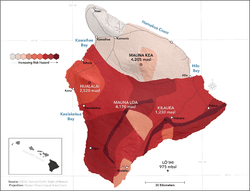
The Island of Hawaiʻi was mapped into 9 Zones meant to portray the future long-term hazard due to lava flow activityUSGS.
Lava Flow Hazard Zones are areas designated by the United States Geological Survey for the Island of Hawaiʻi in the United States. First prepared in 1974 by Donal Mullineaux and Donald Peterson of the USGS and revised in 1992,[1] the maps outline the qualitative hazard posed by lava flows based on the past history of lava flow activity on each of the 5 volcanoes that form the Island of Hawaiʻi. Zone 1 represents the areas that are most hazardous and Zone 9 the least hazardous.[2]
USGS Lava Hazard Zone definitions
The lava flow hazard zones are based on location of eruptive vents, past lava coverage, and topography.[3]
- Zone 1 - Includes summits and rift zones of Kilauea and Mauna Loa volcanoes, where vents have been repeatedly active in historical time.
- Zone 2 - Areas adjacent to and downslope of zone 1. 15-25% of zone 2 has been covered by lava since 1800, and 25-75% has been covered within the past 750 years. Relative hazard within zone 2 decreases gradually as one moves away from zone 1.
- Zone 3 - Areas less hazardous than zone 2 because of greater distance from recently active vents and (or) because of topography. 1-5% of zone 3 has been covered since 1800, and 15-75% has been covered within the past 750 years.
- Zone 4 - Includes all of Hualalai, where the frequency of eruptions is lower than that for Kilauea or Mauna Loa. Lava coverage is proportionally smaller, about 5% since 1800, and less than 15% within the past 750 years.
- Zone 5 - Area on Kilauea currently protected by topography
- Zone 6 - Two areas on Mauna Loa, both protected by topography
- Zone 7 - Younger part of Mauna Kea volcano. 20% of this area was covered by lava in the past 10,000 years.
- Zone 8 - Remaining part of Mauna Kea. Only a few percent of this area has been covered by lava in the past 10,000 years.
- Zone 9 - Kohala Volcano, which last erupted over 60,000 years ago.
The USGS Hawaiian Volcano Observatory maintains an FAQ intended to answer many of the questions that arise from the map and its various uses.[4]
References
- ↑ Thomas L. Wright, Jon Y.F. Chun, Jean Exposo, Christina Heliker, Jon Hodge, John P. Lockwood, and Susan M. Vogt (1992), Map showing lava-flow hazard zones, Island of Hawaii:U.S. Geological Survey Miscellaneous Field Studies Map MF-2193, scale 1:250,000, retrieved 31 May 2014
- ↑ "Island of Hawai`i Lava-flow Hazard Zones". Hawaii Volcano Observatory. United States Geological Survey. Retrieved 31 May 2014.
- ↑ "Hazard Zones for Lava Flows on the Island of Hawai`i". Hawaiian Volcano Observatory. United States Geological Survey. Retrieved 31 May 2014.
- ↑ "Lava-Flow Hazard Zones Island of Hawai'i Frequently Asked Questions". Hawaiian Volcano Observatory. United States Geological Survey. Retrieved 31 May 2014.
This article is issued from Wikipedia - version of the 9/4/2015. The text is available under the Creative Commons Attribution/Share Alike but additional terms may apply for the media files.