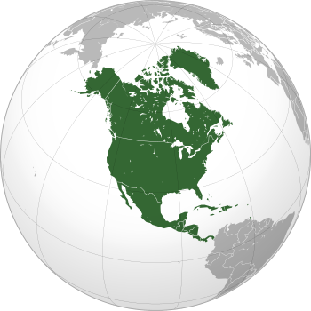
Laurentia
Laurentia or the North American Craton is a large continental craton that forms the ancient geological core of the North American continent. Many times in its past, Laurentia has been a separate continent as it is now in the form of North America, although originally it also included the cratonic areas of Greenland and also the northwestern part of Scotland, known as the Hebridean Terrane. During other times in its past, Laurentia has been part of larger continents and supercontinents and itself consists of many smaller terranes assembled on a network of Early Proterozoic orogenic belts. Small microcontinents and oceanic islands collided with and sutured onto the ever-growing Laurentia, and together formed the stable Precambrian craton seen today.[1][2]
The craton is named after the Laurentian Shield, which in turn is named after the Laurentian Mountains.
Interior platform
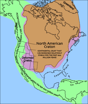
In eastern and central Canada, much of the stable craton is exposed at the surface as the Canadian Shield; when subsurface extensions are considered, the wider term Laurentian Shield is more common, not least because large parts of the structure extend outside Canada. In the United States, the craton bedrock is covered with sedimentary rocks of the interior platform in the Midwest and Great Plains regions. Only in northern Minnesota, Wisconsin, the Adirondacks of New York and the Upper Peninsula of Michigan is the craton bedrock exposed.[3] The sequence of rocks varies from about 1,000 to in excess of 6,100 m (3,500–20,000 ft) in thickness. The cratonic rocks are metamorphic and igneous, while the overlying sedimentary rocks are composed mostly of limestones, sandstones, and shales.[4] These sedimentary rocks were deposited from 650 to 290 million years ago.[5]
Tectonic setting
The metamorphic and igneous rocks of the "basement complex" of Laurentia were formed 1.5 to 1.0 billion years ago in a tectonically active setting.[6] The younger sedimentary rocks that were deposited on top of this basement complex were formed in a setting of quiet marine and river waters. During much of Mississippian time, the craton was the site of an extensive marine carbonate platform on which mainly limestones and some dolostones and evaporites were deposited. This platform extended either from the present Appalachian Mountains or Mississippi Valley to the present Great Basin. The craton was covered by shallow, warm, tropical epicontinental or epicratonic sea (meaning literally "on the craton") that had maximum depths of only about 60 m (200 ft) at the shelf edge. During Cretaceous times, such a sea, the Western Interior Seaway, ran from the Gulf of Mexico to the Arctic Ocean, dividing North America into eastern and western land masses. Sometimes, land masses or mountain chains rose up on the distant edges of the craton and then eroded down, shedding their sand across the landscape.[7][8]
Volcanism
The southwestern portion of Laurentia consists of Precambrian basement rocks deformed by continental collisions (violet area of the image above). This area has been subjected to considerable rifting as the Basin and Range Province and has been stretched up to 100% of its original width.[9] The area contains numerous large volcanic eruptions.
Geological history
- Around 4.03 to 3.58 Ga, the oldest intact rock formation on the planet, the Acasta Gneiss, was formed in what is now Northwest Territories (older individual mineral grains are known, but not whole rocks).[10]
- Around 2.5 Ga, Arctica formed as an independent continent.
- Around 2.45 Ga, Arctica was part of the major supercontinent Kenorland.
- Around 2.1 Ga, when Kenorland shattered, the Arctican craton was part of the minor supercontinent Nena along with Baltica and Eastern Antarctica.
- Around 1.8 Ga, Laurentia was part of the major supercontinent Columbia.
- Around 1.5 Ga, Laurentia was an independent continent.
- Around 1.1 Ga, Laurentia was part of the major supercontinent Rodinia.
- Around 750 Ma, Laurentia was part of the minor supercontinent Protolaurasia. Laurentia nearly rifted apart.
- Around 600 Ma, Laurentia was part of the major supercontinent Pannotia.
- Around Cambrian (542 ±0.3 to 488.3 ±1.7 Ma), Laurentia was an independent continent.
- Around Ordovician (488.3 ±1.7 to 443.7 ±1.5 Ma), Laurentia was shrinking and Baltica got bigger.
- Around Devonian (416 ±2.8 to 359.2 ±2.5 Ma), Laurentia collided against Baltica, forming the minor supercontinent Euramerica.
- Around Permian (299.0 ±0.8 to 251.0 ±0.4 Ma), all major continents collide against each other for forming the major supercontinent Pangaea.
- Around Jurassic (199.6 ±0.6 to 145.5 ±4 Ma), Pangaea rifted into two minor supercontinents: Laurasia and Gondwana. Laurentia was part of the minor supercontinent Laurasia.
- Around Cretaceous (145.5 ±4 to 66 Ma), Laurentia was an independent continent called North America.
- Around Neogene (23.03 ±0.05 Ma until today or ending 2.588 Ma), Laurentia, in the form of North America, crashed into South America, forming the minor supercontinent America.
- Around 250 Ma from now, all continents may crash together, forming the major supercontinent Pangaea Ultima. Laurentia would be part of Pangaea Ultima.
- Around 450-600 Ma from now, Pangea Ultima will eventually rift apart. Laurentia may break off.
References
- ↑ Dalziel, I.W.D. (1992). "On the organization of American Plates in the Neoproterozoic and the breakout of Laurentia". GSA Today. 2 (11). pp. 237–241.
- ↑ Hoffman, Paul F. (1988). "United Plates of America, The Birth of a Craton: Early Proterozoic Assembly and Growth of Laurentia" (PDF). Annual Review of Earth and Planetary Sciences. 16: 543–603. doi:10.1146/annurev.ea.16.050188.002551.
- ↑ Fisher, J.H.; et al. (1988). "Michigan basin, Chapter 13: The Geology of North America". Sedimentary cover - North American Craton. D–2. pp. 361–382.
- ↑ Sloss, L.L. (1988). "Conclusions, Chapter 17: The Geology of North America". Sedimentary cover - North American Craton. D–2. pp. 493–496.
- ↑ Burgess, P.M. Gurnis, M., and Moresi, L. (1997). "Formation of sequences in the cratonic interior of North America by interaction between mantle, eustatic, and stratigraphic processes". Geological Society of America Bulletin. 109 (12): 1515–1535. Bibcode:1997GSAB..109.1515B. doi:10.1130/0016-7606(1997)109<1515:FOSITC>2.3.CO;2.
- ↑ Arlo B. Weil; Rob Van der Voo; Conall Mac Niocaill; Joseph G. Meert (January 1998). "The Proterozoic supercontinent Rodinia: paleomagnetically derived reconstructions for 1100 to 800 Ma". Earth and Planetary Science Letters. 154 (1-4): 13–24. Bibcode:1998E&PSL.154...13W. doi:10.1016/S0012-821X(97)00127-1.
- ↑ Parker, Sybil P., ed. (1997). Dictionary of Geology and Mineralogy. New York: McGraw-Hill.
- ↑ Bates, Robert L. and Julia A. Jackson, ed. (1994). Dictionary of Geological Terms. New York: American Geological Institute: Anchor Books, Doubleday Dell Publishing.
- ↑ "Geologic Provinces of the United States: Basin and Range Province on". USGS.gov website. Retrieved 9 November 2009.
- ↑ Iizuka, Tsuyoshi; Komiya, Tsuyoshi; Ueno, Yuichiro; Katayama, Ikuo; Uehara, Yosuke; Maruyama, Shigenori; Hirata, Takafumi; Johnson, Simon P.; Dunkley, Daniel J. (March 2007). "Geology and zircon geochronology of the Acasta Gneiss Complex, northwestern Canada: New constraints on its tectonothermal history". Precambrian Research. 153 (3-4): 179–208. doi:10.1016/j.precamres.2006.11.017.
- ↑ Sloss, L.L. (1988). "Tectonic evolution of the craton in Phanerozoic time: The Geology of North America". Sedimentary cover - North American Craton. D–2. pp. 25–51.
- ↑ "The Dynamic Earth". Natural Museum of Natural History.
External links
- Paleogeography of the Southwestern US, paleogeographic history of southwestern Laurentia, goes back to 1.7 billion years ago.
- Mesozoic Paleogeography and Tectonic History, Western North America - Paleogeographic history of western Laurentia, goes back to the Permian period.
- USGS Interior Plains Region web site
- The Dynamic Earth, United Plates of America from The Smithsonian National Museum of Natural History
- Map of Laurentia
Continents of the world | ||||||
|---|---|---|---|---|---|---|
| ||||||
.svg.png)
.svg.png)
.svg.png)
.svg.png)
.svg.png)
.svg.png)
.svg.png)
.svg.png)
.svg.png)