Lastage
| Lastage | |
|---|---|
| Neighbourhood of Amsterdam | |
 | |
| Country |
|
| Province |
|
| COROP | Amsterdam |
| Borough | Centrum |
| Time zone | CET (UTC+1) |
Lastage is a neighbourhood in the Centrum district of Amsterdam, in the Netherlands. It is located between the Geldersekade and Oudeschans canals, just east of old medieval city. Today, the neighbourhood is also known as Nieuwmarktbuurt. The area is protected as a heritage site.
History
In the 16th century, the marshy land east of the city developed into an industrial and port area of Amsterdam. Halfway through the 16th century, five ropewalks, some ship's mast factories, and a few shipyards for the caulking and repairing of ships were established here. Due to the location of the area outside the city wall, taxes were much lower and spatial planning regulations were much less strict. The adjacent bend in the IJ inlet called Waal was shallow, which, although unsuitable for merchant vessels, was ideal for docking ships in winter.
During the Guelderian Wars, the area came under threat several times by the troops of Charles of Guelders. When the nearby towns of Weesp and Muiden came under Charles' occupation in the spring of 1508, the city of Amsterdam burnt the area down as a precautionary measure. In December 1512, it was burnt down again, this time at the hands of the Guelders troops.
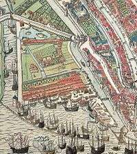
The name Lastage derives from the various ship's ballast-related activities that took place here (ballasten, ontlasten and belasten). Near the Schreierstoren on the quay along the IJ, a crane was built to lift cargo, masts and anchors. A ditch was dug between Montelbaansgracht and Geldersekade around 1530, and was named Rechtboomssloot after Cornelis P. Boom, one of the landowners in the area. The old stream that ran through the Lastage was named Kromboomssloot. Local residents' proposals in 1543 and 1548 to incorporate Lastage into the city were not accepted, despite efforts made by a delegation sent to the Great Council of Mechelen, who brought along a painting of the area by Cornelis Anthonisz. illustrating the local situation. In 1550 there were already 550 houses outside the city walls.[1] In 1564, the residents, backed by the vogt, urged the city government once more to expand the city.[2] Due to the activities in the area posing a potential fire hazard, the city government denied the plea again.
Revolt and war
When the Dutch Revolt broke out in 1566, and the Duke of Alba instituted the Council of Troubles, several of the landowners in the area fled the city and moved abroad. They would return again in 1578 with new insights and trade contacts in the Baltic Sea area.
Immediately after the Alteration (the change of power from a Catholic to a Protestant city council), when Amsterdam finally joined the revolt led by William of Orange against Spain, the new mayors, among whom were some of the landowners on Lastage, made plans for the area and for the expansion and renovation of the port. When a ban on building activities was declared in 1579, the city council wanted to expropriate the land in Lastage, a proposal deemed unacceptable by the local landowners. On the other hand, the high land value made it unacceptable for the city council to consider buying the land instead. In the following years a number of landowners agreed to an estimated value determined by a committee. Two owners, namely the rope maker Claes Burchmansz. Dob and Robrecht Cools, refused and were taken to court. The proceedings were taken all the way up to the highest body, the Court of Holland.[3] The city council was by now in a hurry to make the area more defensible against attacks, especially after Antwerp had fallen and there was a serious risk that the Duke of Parma would advance north towards Amsterdam. Dob and Cools were eventually forced to agree and cooperate, and hastily a defensive rampart was erected, known today as Oudeschans.
The amelioration

Around 1586, the city started drawing up plans to determine how the streets, alleys and defensive walls would be laid out. The local landowners were compelled to demolish the existing buildings, such as fences, ropewalks, drying sheds and tar houses, and to raise the land with sand. The city would provide the sand and the stones needed for pavements and embankments. For this "amelioration", the landowners would have to pay a yet to be determined sum in tax. The construction ban, which had been instituted eight years before, was lifted. Before being allowed to build, the amelioration tax needed to be determined for each plot of land. To this end, each plot of land was measured to calculate the loss of land to newly built streets, ditches and ramparts.
It wasn't until 1589 before construction started on the plots south of the Rechtboomssloot, which the city had now purchased and raised. The building activities would spread eastward from there. At the Oudeschans rampart, a high bridge was built to the island Uilenburg. The island would be part of a second expansion, which was planned to accommodate the now flourishing and rapidly expanding shipbuilding industry. This expansion was intended so the shipyards and mast makers could be relocated, and parts of Lastage could be reorganized. In January 1595, the blacksmiths were banned from Lastage, as they were smelly, noisy and posed a fire hazard.[4] They relocated to the northern part of the island Uilenburg.

Crisis and controversy
Due to a severe economic crisis, plot sales came to a complete standstill around 1596,[5] as is apparent in the city's registrar concerning lots offered for sale at public auctions.[6]
A new conflict arose when surveyor Adriaen Ockersz. proposed a new cost-distribution plan, called Repartition. The renewal of the Waal, which was the harbour at the time, and the straightening of the banks had by then already been finished. Many owners objected to the determined valuation, such as Cleyn Ceesje, a mast maker on the Kromme Waal, who objected to an incorrect calculation. The surveyor, a former locksmith, was allegedly poor at math and had also made grave mistakes when calculating the size of the body of water between Uilenburg and Marken.
To the dismay of the landowners, eight years of accumulated interest had to be paid. The owners especially protested the cost of the timber work and paving, as residents who lived within the old city walls did not have to pay separate taxes for these things. The mayors responded by trying to convince the landowners that paving was extremely important in case of fire: Delft, Haarlem and Leiden were given as examples. Fire was a much debated topic that year, because 26 houses in Warmoesstraat and 33 houses in Sint Antoniesbreestraat had burnt down, and Geldersekade lost several warehouses crammed with valuable Muscovy goods.[7]
Moving ahead

In February 1598, after the bankruptcy of the Doesburg brothers, and court proceedings that lasted up to the Court of Holland, the last two ropeworks were demolished.[8][9] Work then began on Jonkerstraat and Bantammerstraat. By this time, rents in the old city had already increased at an alarming rate, to almost double the amount.[10] Subsequently, construction activity also spread out north and west.
To finance site preparation for the two largest plots in the Lastage, so-called "producers" were used. These were, among others, mayor's daughter Jannetje Pelgrom, her fourth husband (John or Hans Vanderbeke), and Jan de Wael, a mayor and brewer from Haarlem and brother of Pelgrom's first husband. They were essentially developers, possibly in cooperation with the city council. Two other major speculators or land owners were Syvert P. Sem, governor of the Compagnie van Verre and French Hendricksz. Oetgens, who was in charge of urban development and public works.

In 1601 the city government proposed a new appraisal for the Lastage. The proposal took into account the location of the land, which had increased in value, and the losses sustained from upgrading the area. The proposal was rejected by the landowners because it still required interest payments. It took until 1604 before a final, favourable decision was reached. After seven years of struggles between landowners, city council, and the courts, the amount of amelioration was reduced by 30%. The proceeds of over 10,000 guilders were given to the poor and that same year, at the request of the citizens in the area, work started on building a bridge to the Schreierstoren.
Completion
The expansion of Lastage had taken longer than has been assumed by historians for a long time, on the authority of Tobias van Domselaer (1611-1685), a poet and chronicler. Van Domselaer believed that the First Expansion had already been completed in 1593 and described Lastage as an overcrowded slum.[11] In reality, the expansion on Lastage had taken at least fifteen years to complete, from 1589 to 1604. Only on plots owned by the city or the mayors could building commence immediately. The ropers, timber merchants, mast makers and shipwrights, supported by former mayor C.P. Hooft, who would regularly and vigorously defend their case in city council sessions,[12] had all resisted giving up their conveniently located land between the city and the port, if it meant having to relocate at a high cost to Uilenburg or Rapenburg.
Nieuwmarkt
Due to the expansion of the city, the city gate known as Sint Antoniespoort had lost its function. The gate was re-purposed to be used as a stock exchange, a weigh house, and as a guildhall. By partially filling in the canal in front of the gate, a new market square was created, which was to become Nieuwmarkt.

The neighbourhood didn't change much for the next few centuries. With the settlement of Sephardi and Ashkenazi Jews in the adjacent neighbourhoods, some areas of Lastage became part of the Jewish Quarter. After the Nazi occupation of World War II, many of the area's residents had relocated or been deported and large parts of the neighbourhood had fallen into disrepair.

In the 1960s, as part of the 1953 Post-war Reconstruction Plan, the city council planned for a traffic thoroughfare and a metro line to be built through the Lastage area. Under the leadership of Geurt Brinkgreve, an activist for the protection of cultural heritage, campaigning took place between 1967 and 1975 for the conservation of the monumental De Pinto House, which was situated directly on the planned route. Activists from the kraakbeweging (squatters' movement) managed to maintain the property well, in conjunction with the De Pinto Foundation, newly established in 1971 at the initiative of Brinkgreve. By conserving this strategically located building, the construction of the controversial dual carriageway road was effectively blocked. On January 5, 1972 city council decided to abandon the project. The De Pinto Foundation successfully restored the heavily neglected house in 1974-1975.
In addition to the road plan, many planned office buildings were scrapped as well, in favour of homes. Between 1975 and 1984, new residential developments arose around the Pinto House. The eastern line of the new Amsterdam Metro did go ahead as planned, and the method used to construct the metro tunnels required whole city blocks to be demolished. On March 24 and April 8, 1975, riots erupted over the demolition of homes that were still in good condition.[13][14]
Today, Lastage is a popular neighbourhood due to its relative tranquillity in the midst of a lively, central location in the city. Lastage borders Chinatown, De Wallen, the Waterlooplein area and is located near Centraal Station.
Listed buildings and architecture

Notable examples:
- Montelbaanstoren (1516), Oudeschans 2
- Zuiderkerk (1603-1614), Zuiderkerkhof 72
- Huis De Pinto (1680), Sint Antoniesbreestraat 69
- "The House with the Clock" (19th century), Sint Antoniesbreestraat 2
- Scheepvaarthuis (phase I - 1916; phase II - 1928), Prins Hendrikkade 108
Further reading: Complete list of listed buildings in Lastage (in Dutch)
External links
- Nieuwmarktbuurt Website (in Dutch)
- Neighbourhood Association (in Dutch)
- De Nieuwmarktbuurt en het bovengrondse spoor van de Metro (in Dutch)
References
- ↑ J.E. Abrahamse (2010) De grote uitleg van Amsterdam. Stadsontwikkeling in de 17e eeuw, p. 12.
- ↑ Fremery, W.H.M. de (1925) De opkomst der Amsterdamsche haven. Jaarboek Amstelodamum, p. 23-110.
- ↑ Kwijtschelding 11-16, 11-41 en 11-53.
- ↑ J.E. Abrahamse (2010) De grote uitleg van Amsterdam. Stadsontwikkeling in de 17e eeuw, p. 35; 99.
- ↑ Lesger, C. (1986) Huur en conjunctuur. De woningmarkt in Amsterdam, 1550-1850, p. 45-6.
- ↑ Gemeentearchief Amsterdam 5039-inv. nr. 177, 178 en 179.Register van door de stad bij publieke veiling ter verkoop aangeboden percelen.
- ↑ Tussenbroek, G. van (2009) Amsterdam in 1597, p. 142, 231.
- ↑ Archief van de Vroedschap (resoluties met munimenten of bijlagen) GAA 5025-8, f. 436-439.
- ↑ Register van Decreten van het Hof van Holland, Nationaal Archief 3.03.01.01, 27 juli 1598
- ↑ Lesger, C. (1986) Huur en conjunctuur. De woningmarkt in Amsterdam, 1550-1850, p. 44-6.
- ↑ Domselaer, T. van (1665) Beschrijving van Amsterdam, p. 239.
- ↑ J.E. Abrahamse (2010) De grote uitleg van Amsterdam. Stadsontwikkeling in de 17e eeuw, p. 54-59.
- ↑ Hoe de Nieuwmarktbuurt werd gered, door Walther Schoonenberg, in Amstelodamum; januari - maart 2013, pagina's 3-23.
- ↑ Cate, F. ten (1988) Dit volckje seer verwoet Een geschiedenis van de Sint Antoniesbreestraat, p. 10-4.
Neighborhoods of Amsterdam | ||
|---|---|---|
| Centrum (Centre) | ||
| Nieuw-West (New West) | ||
| Noord (North) | ||
| Oost (East) |
| |
| West | ||
| Zuid (South) | ||
| Zuidoost (Southeast) |
| |
| Westpoort |
| |
Add'l. former boroughs: De Baarsjes - Geuzenveld-Slotermeer - Oost-Watergraafsmeer - Oud-West - Oud-Zuid - Slotervaart - Westerpark - Zeeburg - Zuideramstel | ||
Coordinates: 52°22′23″N 4°54′12″E / 52.373084°N 4.903207°E