Las Trampas Regional Wilderness
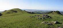

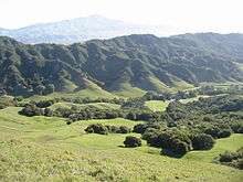
Las Trampas Regional Wilderness is a 5,342-acre (21.62 km2) regional park located in Alameda and Contra Costa counties in Northern California. Las Trampas is Spanish for "the traps". The park belongs to the East Bay Regional Park District (EBRPD). [1] It consists of two long, hilly ridges (Las Trampas Ridge on the east and Rocky Ridge on the west) flanking a narrow valley along Bollinger Creek which contains a horse stable and visitor parking. Some of the hiking trails include steep sections; they can involve as much as 900 feet (270 m) of elevation change. The park has been described as "the tough guy of the East Bay Regional Park District."[2]
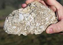
Bicycles are allowed on half of the trails; equestrians and hikers on all of the trails. Dogs are allowed. Cows, calves, steers and an occasional free-ranging bull can be encountered on the trails; their grazing keeps the grass short for summer fire safety.[1] Deer, coons, and skunks can be seen, as well as hawks, vultures and an occasional eagle. The commonest trees are California bay laurel and coast live oak. Some of the exposed rocks contain compressed layers of fossils.[1]

On its eastern border, the park encloses the triangular property of the Eugene O'Neill National Historic Site on all three sides, with access from Las Trampas via hiking trails or from Danville by single-lane road. The eastern section of the park also contains several secluded waterfalls, most of which are difficult to reach.[3]

The western-slope portion of Las Trampas is a sensitive EBMUD (East Bay Municipal Utility District) watershed and is closed to hiking except by permit.
References
External links
| Wikimedia Commons has media related to Las Trampas Regional Wilderness. |
- Las Trampas Regional Wilderness official web page
- Topographic trail map of Las Trampas Regional Wilderness
- James Kew: resident alien. Las Trampas Regional Wilderness
Coordinates: 37°49′N 122°03′W / 37.82°N 122.05°W