Las Acacias (Madrid)
| Las Acacias | |
|---|---|
| Ward of Madrid | |
|
View of the Calle de Toledo | |
 Las Acacias within Arganzuela and Madrid | |
| Country |
|
| Aut. community |
|
| Municipality |
|
| District |
|
| Area | |
| • Total | 1.08 km2 (0.42 sq mi) |
| Population | 37,727 (2,006) |
| • Density | 34,932/km2 (90,470/sq mi) |

Las Acacias is a ward (barrio) of Madrid belonging to the district of Arganzuela. Its code number is 22 and, as of 2006, its population was of 37,727.
Geography
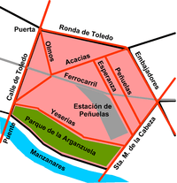
Acacias is located in city center and is crossed, at its south-eastern borders, by the river Manzanares. The ward has a pentagonal form, bordered by the roads Calle de Toledo, Ronda de Toledo, Calle de Embajadores, Paseo de Santa Maria de la Cabeza and Paseo de la Yeserías (parallel to the Manzanares), at the entrance of Arganzuela Park.
Acacias borders with the districts of Centro (north-west), Carabanchel (south-east) and with the Arganzuelan wards of Imperial (west), Palos de Moguer (north-east), Las Delicias (a single point in the east) and La Chopera (south-east).[1]
Some important buildings located at its limits are the Bridge of Toledo (Puente de Toledo), between the Paseo de la Yeserias and the Calle de Toledo; and the Gate of Toledo (Puerta de Toledo), between the Calle de Toledo and the Ronda de Toledo.
Transport
Las Acacias is served by the Metro Line 5 stations of Puerta de Toledo, Acacias and Pirámides. It is also served by the Cercanías (commuter rail) stations of Pirámides and Embajadores.
Photogallery
 The Gate of Toledo
_04b.jpg) The Bridge of Toledo, over the Manzanares, from Arganzuela Park
The Bridge of Toledo, over the Manzanares, from Arganzuela Park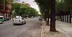 Paseo de la Yeserías
 Remains of the walls of Philip IV of Spain
References
External links
- Orthophoto of the district of Arganzuela (Las Acacias is the n. 22)
Coordinates: 40°24′5.12″N 3°42′17.77″W / 40.4014222°N 3.7049361°W