Larned, Kansas
| Larned, Kansas | |
|---|---|
| City | |
|
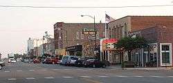
Business District (2009) | |
 Location within Pawnee County and Kansas | |
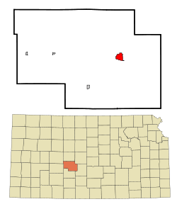
 KDOT map of Pawnee County (legend) | |
| Coordinates: 38°10′56″N 99°6′6″W / 38.18222°N 99.10167°WCoordinates: 38°10′56″N 99°6′6″W / 38.18222°N 99.10167°W | |
| Country | United States |
| State | Kansas |
| County | Pawnee |
| Area[1] | |
| • Total | 2.39 sq mi (6.19 km2) |
| • Land | 2.39 sq mi (6.19 km2) |
| • Water | 0 sq mi (0 km2) |
| Elevation | 2,005 ft (611 m) |
| Population (2010)[2] | |
| • Total | 4,054 |
| • Estimate (2015)[3] | 3,967 |
| • Density | 1,700/sq mi (650/km2) |
| Time zone | Central (CST) (UTC-6) |
| • Summer (DST) | CDT (UTC-5) |
| ZIP code | 67550 |
| Area code(s) | 620 |
| FIPS code | 20-38700 |
| GNIS feature ID | 0475852 [4] |
| Website | cityoflarned.org |
Larned is a city in and the county seat of Pawnee County, Kansas, United States.[5] As of the 2010 census, the city population was 4,054.[6]
History
Larned was laid out in 1873.[7] The first post office was established at Larned in 1872.[8]
The city drew its name from nearby Fort Larned, which operated from 1859 to 1878, and named for Colonel Benjamin F. Larned, U.S. Army Paymaster from July 1854 to his death September 6, 1862.
Geography
Larned is located at 38°10′56″N 99°6′6″W / 38.18222°N 99.10167°W (38.182109, -99.101696).[9] According to the United States Census Bureau, the city has a total area of 2.39 square miles (6.19 km2), all land.[1]
Climate
The climate in this area is characterized by hot, humid summers and generally mild to cool winters. According to the Köppen Climate Classification system, Larned has a humid subtropical climate, abbreviated "Cfa" on climate maps.[10]
Demographics
| Historical population | |||
|---|---|---|---|
| Census | Pop. | %± | |
| 1880 | 1,066 | — | |
| 1890 | 1,861 | 74.6% | |
| 1900 | 1,583 | −14.9% | |
| 1910 | 2,911 | 83.9% | |
| 1920 | 3,139 | 7.8% | |
| 1930 | 3,532 | 12.5% | |
| 1940 | 3,533 | 0.0% | |
| 1950 | 4,447 | 25.9% | |
| 1960 | 5,001 | 12.5% | |
| 1970 | 4,567 | −8.7% | |
| 1980 | 4,811 | 5.3% | |
| 1990 | 4,490 | −6.7% | |
| 2000 | 4,236 | −5.7% | |
| 2010 | 4,054 | −4.3% | |
| Est. 2015 | 3,967 | [3] | −2.1% |
| U.S. Decennial Census[11] 2012 Estimate[12] | |||
2010 census
As of the census[2] of 2010, there were 4,054 people, 1,824 households, and 1,027 families residing in the city. The population density was 1,696.2 inhabitants per square mile (654.9/km2). There were 2,130 housing units at an average density of 891.2 per square mile (344.1/km2). The racial makeup of the city was 92.2% White, 2.7% African American, 0.4% Native American, 0.6% Asian, 0.1% Pacific Islander, 1.4% from other races, and 2.6% from two or more races. Hispanic or Latino of any race were 7.0% of the population.
There were 1,824 households of which 27.0% had children under the age of 18 living with them, 42.1% were married couples living together, 10.5% had a female householder with no husband present, 3.7% had a male householder with no wife present, and 43.7% were non-families. 39.5% of all households were made up of individuals and 18.6% had someone living alone who was 65 years of age or older. The average household size was 2.18 and the average family size was 2.89.
The median age in the city was 42.7 years. 23.9% of residents were under the age of 18; 6.8% were between the ages of 18 and 24; 21.9% were from 25 to 44; 27.9% were from 45 to 64; and 19.7% were 65 years of age or older. The gender makeup of the city was 48.0% male and 52.0% female.
2000 census
As of the census of 2000, there were 4,236 people, 1,826 households, and 1,113 families residing in the city. The population density was 1,823.4 people per square mile (705.0/km²). There were 2,079 housing units at an average density of 894.9 per square mile (346.0/km²). The racial makeup of the city was 90.91% White, 3.75% African American, 0.97% Native American, 0.76% Asian, 1.77% from other races, and 1.84% from two or more races. Hispanic or Latino of any race were 5.38% of the population.
There were 1,826 households out of which 27.3% had children under the age of 18 living with them, 48.6% were married couples living together, 9.0% had a female householder with no husband present, and 39.0% were non-families. 36.5% of all households were made up of individuals and 17.8% had someone living alone who was 65 years of age or older. The average household size was 2.20 and the average family size was 2.87.
In the city the population was spread out with 23.5% under the age of 18, 6.4% from 18 to 24, 23.3% from 25 to 44, 24.6% from 45 to 64, and 22.1% who were 65 years of age or older. The median age was 43 years. For every 100 females there were 90.3 males. For every 100 females age 18 and over, there were 87.3 males.
The median income for a household in the city was $33,895, and the median income for a family was $46,776. Males had a median income of $27,138 versus $20,927 for females. The per capita income for the city was $19,936. About 5.9% of families and 7.4% of the population were below the poverty line, including 8.1% of those under age 18 and 10.8% of those age 65 or over.
Media
The local newspaper is Larned Tiller & Toiler.[13]
Economy
- USD 495, local school district
- Larned State Hospital, west of Larned
- Larned Correctional Mental Health Facility, west of Larned
- Larned Juvenile Correctional Facility, west of Larned
Area attractions
- Santa Fe Trail Center, 1349 K-156 Hwy, museum devoted to the history of the Santa Fe Trail.
- Fort Larned National Historic Site, located approximately 5.5 miles (8.9 km) west of the city of Larned.
Notable people
- Belle Jennings Benchley, "the Zoo lady", former director of the San Diego Zoo
- Gene Keady, current Big Ten sportscaster, former head coach for the Purdue Boilermakers men's basketball team
- Hal Patterson, American player of Canadian football
- Glee S. Smith, Jr.. Kansas state legislator and lawyer
- Ralph Terry, retired New York Yankees pitcher
- Mitch Webster, retired Major League Baseball outfielder
- John Zook, football player, all-state, all Big 8 (Kansas University), all-pro NFL
See also
References
- 1 2 "US Gazetteer files 2010". United States Census Bureau. Retrieved 2012-07-06.
- 1 2 "American FactFinder". United States Census Bureau. Retrieved 2012-07-06.
- 1 2 "Annual Estimates of the Resident Population for Incorporated Places: April 1, 2010 to July 1, 2015". Retrieved July 2, 2016.
- ↑ "US Board on Geographic Names". United States Geological Survey. 2007-10-25. Retrieved 2008-01-31.
- ↑ "Find a County". National Association of Counties. Retrieved 2011-06-07.
- ↑ "2010 City Population and Housing Occupancy Status". U.S. Census Bureau. Retrieved March 27, 2011.
- ↑ Kansas State Historical Society (1916). Biennial Report of the Board of Directors of the Kansas State Historical Society. Kansas State Printing Plant. p. 260.
- ↑ "Kansas Post Offices, 1828-1961". Kansas Historical Society. Archived from the original on October 9, 2013. Retrieved 22 June 2014.
- ↑ "US Gazetteer files: 2010, 2000, and 1990". United States Census Bureau. 2011-02-12. Retrieved 2011-04-23.
- ↑ Climate Summary for Larned, Kansas
- ↑ United States Census Bureau. "Census of Population and Housing". Retrieved February 15, 2014.
- ↑ "Annual Estimates of the Resident Population: April 1, 2010 to July 1, 2012". Retrieved February 15, 2014.
- ↑ Weintraub, Boris (Apr 19, 1984). "Unusual names bestowed on a few U.S. newspapers". The Bulletin. p. 16. Retrieved 22 May 2015.
Further reading
- Kansas
- History of the State of Kansas; William G. Cutler; A.T. Andreas Publisher; 1883. (Online HTML eBook)
- Kansas : A Cyclopedia of State History, Embracing Events, Institutions, Industries, Counties, Cities, Towns, Prominent Persons, Etc; 3 Volumes; Frank W. Blackmar; Standard Publishing Co; 944 / 955 / 824 pages; 1912. (Volume1 - Download 54MB PDF eBook),(Volume2 - Download 53MB PDF eBook), (Volume3 - Download 33MB PDF eBook)
- USA
- The Story of the Marking of the Santa Fe Trail by the Daughters of the American Revolution in Kansas and the State of Kansas; Almira Cordry; Crane Co; 164 pages; 1915. (Download 4MB PDF eBook)
- The National Old Trails Road To Southern California, Part 1 (LA to KC); Automobile Club Of Southern California; 64 pages; 1916. (Download 6.8MB PDF eBook)
External links
| Wikimedia Commons has media related to Larned, Kansas. |
- City
- Schools
- USD 495, local school district
- Historical
- Fort Larned National Historic Site
- Santa Fe Trail Center
- Historic Passenger Rail service in Pawnee County
- Postcards from Larned
- Historic Images of Larned, Special Photo Collections at Wichita State University Library.
- Maps
- Larned City Map, KDOT
Municipalities and communities of Pawnee County, Kansas, United States | ||
|---|---|---|
| Cities | 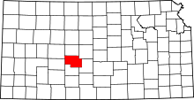 | |
| Unincorporated communities | ||